Archive for the ‘Google Earth’ Category

Friday Grab bag: a little bit of everything

Friday, June 17th, 2011

1. Google has uploaded some beautiful new satellite imagery of Pyongyang. Some parts of it are easier to see than others, and I have not gone through it all, but here are some fun, quick discoveries:

1. There appears to be a new aircraft runway in Ryongsong-guyok (룡성구역, 39.127835°, 125.777533°).  Maybe not, but maybe.

2. The Ryugyong Hotel is looking more and more like a space ship:

3. We can see 2012 building construction all over the place.  Below are the new apartments Kim Jong-il recently visited (L) at the foot of Haebang Hill and (R) behind the Central District Market (for artists).

Here and here are the KCNA stories about Kim’s visits to the sites.

Here is a photo of the artist-housing under construction.

The Haebang Hill apartments are built on the former location of the “Monument to the Fallen Fighters of the Korean People’s Army”.  See a picture of this former monument here.


2. DPRK TKD in USA. As I mentioned a couple of days ago, a North Korean Taekwondo team toured the northeastern US this week.  I wish I could have seen one of the shows…but here are some clips from the New York show on Youtube: Part 1Part 2Part 3Part4.

They did a great job and are tremendous athletes.  I hope they are able to return soon–and make it a little further south.


3. DPRK sand animation. This week KCNA posted some very interesting video of a “sand art” demonstration.  Very skilled performance. A viewer was able to rip the video and post it to YouTube.

Pictured above is the “Ryugyong Hotel fireworks” part of the performance.  Part 1 of the piece is here.  Part 2 of the piece is here.  The whole performance is well worth watching. If I could ever be a tourist to the DPRK again, I would want to see one of these performances.

UPDATE: A special thanks to Prof. Stephan Haggard for offering a helpful explication of the piece.

In a similar vein, this piece remains my favorite of the genre (from Ukraine).


2. Kim’s Train (Retro). Last week I posted recent video footage taken from inside Kim Jong-il’s train.  This week I post some retro footage taken in the 1970s(?):

You can see the video here.  The room set up is essentially the same, though Kim’s tastes have obviously changed!


3. The CNC backpack.

Here is the source.  Learn more about CNC here.


4. A North Korean artist reproduced da Vinci’s Last Supper for an art show in Russia. See the Russian-language version of the BBC here (picture-8 ). (h/t L.P.)


Share

Rason’s Chinese investor tour

Friday, June 10th, 2011

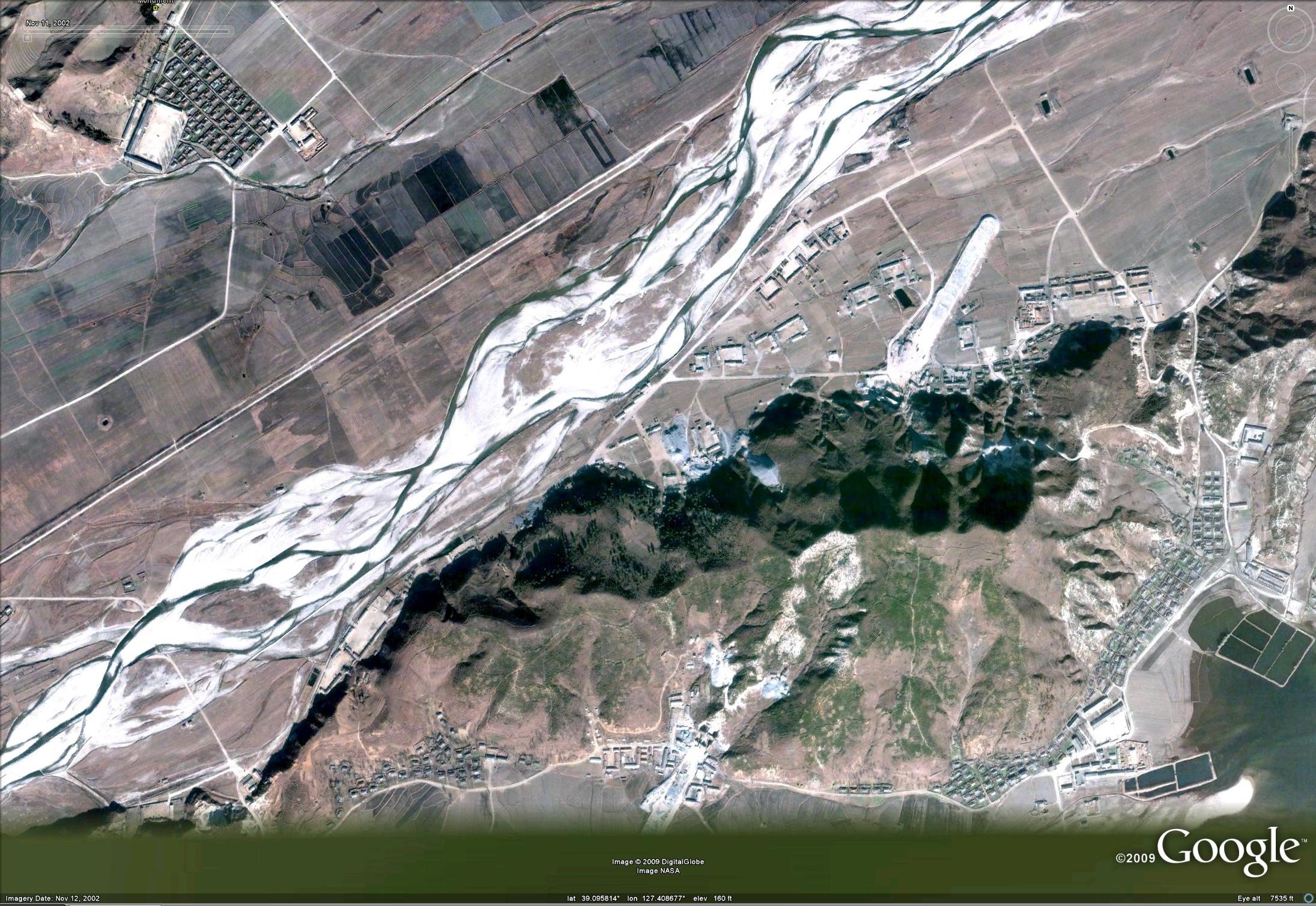
Pictured above (Google Maps): The Wonjong Bridge and route traveled by Chinese drivers from the border to Rason

UPDATE 6 (2011-6-15): Here is a great news video of the Chinese driving tour:

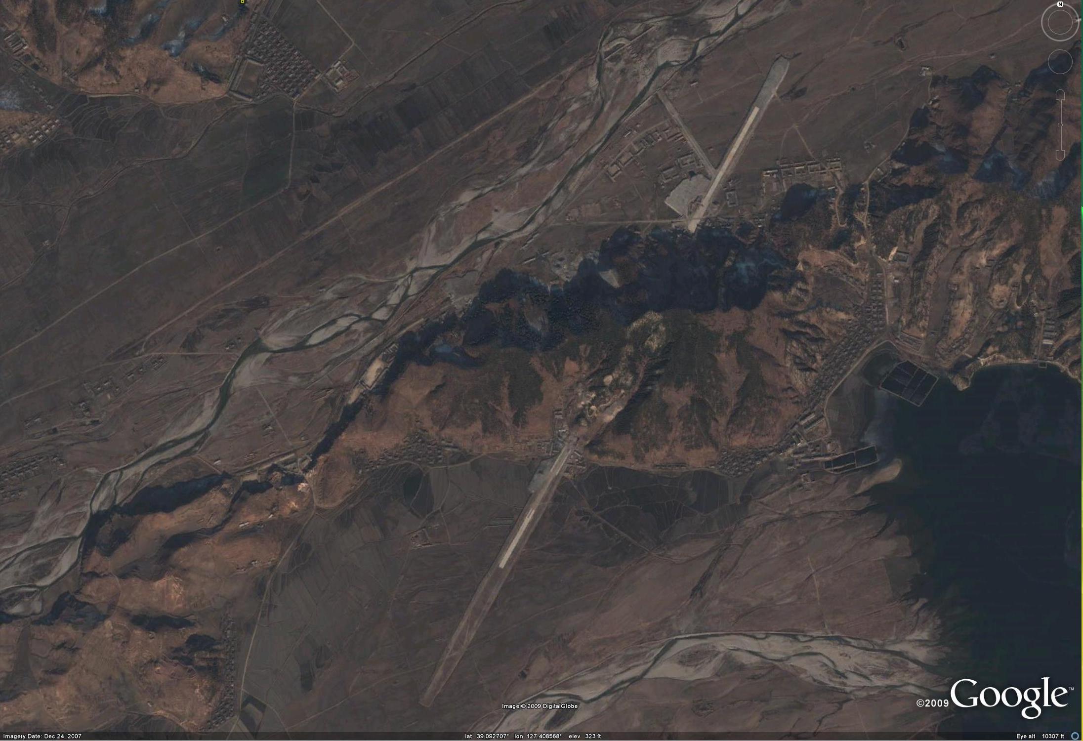
Click image to watch video at YouTube

UPDATE 5 (2011-6-10): Barbara Demick writes in the L.A. Times:

No doubt the most attractive part of the package for China is the access to the port in Rajin, part of a larger special economic zone known as Rason. In 1860, China’s weak Qing dynasty signed a treaty that ceded a long strip of coastline to Russia, leaving Chinese Manchuria landlocked. The use of the port in Rajin makes it easier to transport raw materials from the resource-rich region of northeastern China to the industrial hubs in southern China. In December, the Dalian-based Chuangli group, which had spent $3.6 million renovating the port, shipped 20,000 tons of Manchurian coal through the North Korean port to Shanghai.

“It is faster and cheaper to ship through North Korea’s port than to use the railroads,” said a businessman who was in Rajin this week as preparations were underway for the groundbreaking. “Everybody in Rajin is very excited about what the Chinese are doing. They think it will bring jobs.”

UPDATE 4 (2011-6-9): KCNA coverage of the Hwanggumphyong ground breaking ceremony also mentioned developments in Rason:

The [Hwanggumphyong] ceremony was followed by announcing the start of the reconstruction of the Rajin Port-Wonjong road, ground-breaking ceremonies of Athae Rason Cement Factory and the Rason, DPRK-Jilin Province, China High Efficiency Agricultural Model District and departing ceremonies of Chinese domestic freight transit transportation via Rajin Port and private car tourism as the first phase projects for the start of the joint development of the zone.

UPDATE 3 (2011-6-10): China’s Global Times reports on the Chinese business tour:

The first self-drive tour from China to North Korea started on Thursday, with around 100 tourists setting off from Changchun, Jilin Province, to Rason, North Korea, China News Service (CNS) reported.

A total of 24 vehicles carrying around 100 travelers including well-known entrepreneurs, officials with the Changchun Tourism Bureau and provincial government took part in the tour, according to a staff member surnamed Wang with the publicity department of the China Youth Travel Service (CYTS) Tours Corporation Jilin Branch, which organized the tour.

“We’ve spent more than a month preparing for the activity. We sent invitations to tourists and negotiated with the Rason government,” Wang told the Global Times on Thursday.

The tour will last from June 9 to 11, and the cost for each tourist was more than 1,000 yuan ($149), an anonymous staff member with the executive office of the CYTS Tours Corporation Jilin Branch told the Global Times on Thursday.

After assembling at the Changchun Exhibition and Conference Center on Thursday morning and identifying each car with a number, the tourists began their journey at 7 am and planned to reach Hunchun, the border city in Jilin Province that leads to North Korea, in the afternoon, according to the CNS report.

“The 24 vehicles were all provided by the tourists themselves, but we have dispatched a car to lead them and they were all given interphone sets in case some of them fall behind,” she told the Global Times on Thursday.

After passing through Hunchun, the tourists will reach Rason district and tour guides dispatched by the Rason government will lead them to visit Rajin Port and Rajin Bay.

There, they will be able to enjoy children’s performances and also visit local scenic spots, according to the staff member with the executive office of the CYTS Tours Corporation Jilin Branch.

“There were so many people who called to ask about this activity, so I believe we will organize a second tour in the near future,” she told the Global Times.

The North Korean government plans to develop Rason, located in the border area between China and North Korea, into an international economic zone. At the end of May, the North Korean government allowed Chinese tourists to make the self-drive trip to Rason to enjoy its scenery, according to CNS.

“Allowing self-drive tours from China to North Korea means a lot to both countries, because it will increase the interaction and enhance mutual understanding between the two peoples, and consequently, enhance friendly relations between the two countries,” Yang Zhenzhi, a professor at the School of History and Culture (Tourism) with Sichuan University, told the Global Times, adding that the decision will also help to boost economic ties between the two countries.

UPDATE 2 (2011-6-4): According to an earlier report in the Donga Ilbo a “groundbreaking ceremony” for the Rason area will also take place Thursday (June 9).  No doubt this will take place just before the convoy of Chinese investors crosses into the DPRK.  According  to the article:

Sources in China`s Yanbian Autonomous District in Jilin Province and Dandong in Liaoning Province said Friday that the groundbreaking ceremony for the special district in Rason Special City will be held Thursday and that for the development of Hwangkumpyong in the Yalu River near Shinuiju will come Tuesday.

UPDATE 1 (2011-6-6): The news out today indicates that, as earlier reported (see original post below), a convoy of Chinese investors will travel the new road from Wonjong to Rason to explore investment opportunities.  There are a few interesting differences between the time the story was originally published (in April) and today:

Firstly, and the least interesting point, the “investment convoy” is about nine days behind the original schedule. Originally the convoy was to depart for the DPRK on June 1.  The convoy now appears to be departing on June 9.

Secondly, the convoy appears to be operated by a different Chinese tour company.  Back in April the convoy was being coordinated through the Sanjiang International Travel Agency in Hunchun.  The convoy departing this week, however, is run by CYTS Tours.  I do not know enough about either of these businesses to speculate on treasons for the last minute switch in partners.

Thirdly, the cost of the trip has increased significantly.  In April the Sanjiang Travel Agency said the trip would cost 680 Yuan.  Now CYTS Tours says the cost will be 1450 Yuan per person, and the convoy size will be limited to 30 vehicles.

Here is the most recent report in the Donga Ilbo:

Chinese nationals can start traveling Thursday to Rason, a free trade zone in North Korea`s northeastern region, with their own cars for three days.

This is in line with the development plan linking the Chinese cities of Changchun, Jilin and Tumen that the Chinese government is promoting, China’s Xinhua News Agency said Friday.

For starters, the service launched by CYTS Tours will begin with fewer than 30 cars. Travel costs will be 1,450 yuan (224 U.S. dollars) per person, including lodging and eating. Whether anyone has applied remains unknown, however.

People who will start from Changchun Thursday will drive 500 kilometers to Hunchun in Yanbian Korean Autonomous Prefecture and then enter North Korea through the maritime customs at Quanhe. After crossing the Tumen River, they will go through immigration procedures at the customs office in the North Korean village of Wonjeong-ri and then go to Rason through a Hunchun-Rason road under construction.

The travelers will tour the port of Rajin and then tour Rajin Bay by boat. They will watch a children’s show and visit Sea Village and Wang Hai Guo, where the late founder of North Korea Kim Il Sung visited.

A source at CYTS Tours said, “The product was designed as a part of the (Chinese) government’s travel development plan for Changchun, Jilin and Tumen.”

ORIGINAL POST (2011-4-4): According to the Choson Ilbo:

North Korea is reportedly allowing Chinese motorists to drive to the special economic zone of Rajin-Sonbong so they can look around for investment opportunities there.

A spokesman for Sanjiang International Travel Agency in Hunchun, China on Friday said a group of Chinese motorists will tour Rajin-Sonbong and Duman near the North Korean-Chinese-Russian border under an initiative by the Tourism Bureau of Jilin Province on May 31-June 1. Sanjiang specializes in travels to the lower reaches of the Duman (Tumen) River in North Korea and Russia.

The two-day trip will cost 680 yuan (approximately W115,000) per person.

The Sanjiang staffer said small groups of Chinese motorists have gone to Rajin-Sonbong before, but this is the first large-scale trip organized by the Jilin provincial government and the first time tourists are visiting Duman.

The aim is apparently to lure Chinese investors to Rajin-Sonbong. Early this year, the North agreed with Hunchun city to build a large recreation center and park in its special economic zone.

Back in March 2008, the North allowed South Korean motorists to travel to the scenic Mt. Kumgang resort, but only four months later the tours were suspended after a South Korean tourist was shot dead by a North Korean soldier.

Related historical information:

1. Bridge on China-North Korea border being renovated (2010-4-13)

2. DPRK-China border bridge opens (2010-6-23)

3. Who uses Rajin’s Ports? (2010-5-23)

4. Rason port facilitates intra-China coal distribution (2011-1-4)

Read the original stories here:
China to allow nat`ls to travel to Rason, N.Korea, by car
Donga Ilbo
2011-6-6

Chinese Motorists to Tour N.Korean Investment Zones
Choson Ilbo
2011-4-5

Share

Friday grab bag: everything but the kitchen sink

Thursday, June 2nd, 2011

DPRK Public Trial Video

There is a video on YouTube (via South Korean television) that purportedly shows a public trial that took place last April in Sinuiju (RFA). The trial took place in the Sinuiju central Square:

Sinuiju-square

There is an (increasingly hard to find) older video of a public trial in Hamju County (함주군) which clearly matches the satellite imagery. You can see the video here.  The stadium where it was filmed is here.

Kim Jong-il’s Only Televised Speech in the DPRK

In an earlier “Friday Fun” post, I linked to a parody of Kim Jong Il’s only televised speech in the DPRK.  Here is his actual and only speech!

Kimchi Dog

For the dog lovers: I thought this clip of a North Korean dog carrying a kimchi bucket near Kim Il-sung square in Pyongyang was cute.

DPRK No 2 Happiest Country?

Chinese blog post, picked up by the Shanghaiist, went viral this week.  The story:

China is the happiest place on earth(!!) according to a new global happiness index released by North Korea’s Chosun Central Television. China earned 100 out of 100 points, followed closely by North Korea (98 points), then Cuba, Iran, and Venezuela. Coming in at 203rd place is America (or rather “the American Empire”, 美帝国), with only 3 happiness points. South Korea got a measly 18 points for 152nd place.

Frankly, I don’t think most North Koreans would believe this story if they saw it on television.

I tried to learn more, but the source material is proving difficult to locate. There is no mention of the “study” in KCNA.  I have also gone through my archives of recent North Korean television footage and I am unable to locate the broadcast.  Does anyone know when the original video clip was aired?

For what it is worth, Freedom House just ranked the DPRK as the country with the world’s worst human rights record (again).

Did the DPRK Get a New Yacht?

While scouring new imagery of Wonsan on Google Earth, I noticed that a port, holding what many believe are ships for elite use, seemed to be +1 yacht.  Both are about 48m long.  The two pictures above are dated 2002-11-11(left) and 2009-10-3 (right). It is possible that the second yacht was moved from another location.  In 2009 the sale of two yachts to the DPRK was detected and halted.

New Google Earth Imagery of the Kumgang Resort

We can now see all the properties that the DPRK has “seized” from Hyundai-Asan: Family Reunion Center,  Kumgangsan Hotel, Mokranwon Restaurant, Kumgang Golf Course and more!

Share

Kaesong production sets monthly record

Wednesday, May 18th, 2011

Pictured above (Google Earth): Growth of the Kaesong Industrial Center (Apr. 2004, Jan. 2006, Sept. 2009)

According to Yonhap:

South Korean factories in an industrial complex in North Korea produced goods worth US$34.7 million in March, setting a monthly output record since the two Koreas launched the zone in 2004, Seoul’s Unification Ministry said Wednesday.

The complex, a key symbol of rapprochement between the two Koreas, combines the South’s technology and management expertise with the North’s cheap labor.

More than 46,000 North Koreans work for about 120 South Korean firms operating in the North Korean border city of Kaesong to produce clothes, utensils, watches and other low-tech goods.

The two divided Koreas managed to maintain the zone despite a chill in their relations over the North’s two deadly attacks on the South last year that killed 50 South Koreans.

A couple of days ago I posted a story about the growth in number of North Korean workers at the complex.

UPDATE (2011-5-27): The Wall Street Journal’s Korea Real-Time offers some 2010 joint-Korean trade and aid umbers:

For the full year, general trade between the two Koreas amounted to $118 million, down 54% from $256 million in 2009.

But the joint industrial complex at Kaesong, a city just inside North Korea on the west side of the inter-Korean border, continued to flourish.

The volume of trade at the Kaesong Industrial Complex, goods moving into the approximately 120 factories there and then being shipped back south after North Korean workers added value, rose 54% to $1.44 billion last year from $941 million in 2009.

As part of the penalties following the Cheonan incident, the South Korean government limited the number of South Koreans who could stay at the Kaesong complex. The result: one-day visits to the complex soared, lifting the total number of South Koreans who visited the North.

For all of 2010, 130,119 South Koreans went to the North while just 130 North Koreans visited the South. In 2009, 120,616 South Koreans went to the North and 246 North Koreans visited the South.

South Korea’s assistance to North Korea also dropped sharply last year, to 30.1 bililon won from 77.5 billion won a year earlier. The South’s direct government assistance was 8 billion won, down from 10.4 billion won in 2009.

Private assistance from South Korea also fell to 20 billion won in 2010, from 37.7 billion won in 2009.

Read the full story here:
Production at Koreas’ industrial complex sets monthly record
Yonhap
2011-5-18

Share

DPRK’s largest communications center

Monday, May 2nd, 2011

UPDATE 1 (2011-4-29): Martyn Williams claims to have identified the name and purpose of the large communications center I identified on satellite imagery of North Korea:

If you’ve ever listened to The Voice of Korea on shortwave, you’ve probably heard broadcasts from this transmitter site. Kujang is one of the largest transmitter locations in the DPRK with, according to official records, 5 shortwave transmitters each capable of delivering a 200kW signal. That’s powerful enough to reach most corners of the world, given a clear frequency and good conditions.

I am not convinced that the site posted below is actually the Kujang short-wave transmitter. First of all, the towers are not located in the right county (Hyangsan, not Kuajng) and there are many more than five transmission towers.

I will post more as I uncover it.

ORIGINAL POST (2010-2-11): In Myohyangsan County ( 40.078134°, 126.111790°) is the largest collection of communications towers I have found in the DPRK…more than 20 towers clustered together.

communications-thumbanil.JPG

You can click on the image to see a larger version.

Hat tip to a reader.

Share

DPRK makes progess on ‘Thunderbirds runway’

Friday, April 15th, 2011

UPDATE 2 (2011-4-25): Strategy Page comments on the technology that makes these facilities obsolete:

Over the last decade, there has been a pronounced slowdown in North Korean work on underground air bases. Part of this may be the result of growing energy shortages up north, and the frequent blackouts. It’s not just electricity that’s been in short in North Korea over the last decade, it’s everything. That includes construction equipment, especially the specialized stuff needed for digging tunnels into the sides of mountains. But work continues, slowly, mostly with manual labor, to expand the network of underground parking and maintenance facilities for aircraft, as well runway extensions. These sheltered air bases begin underground, then exit the mountain and continue outside. Apparently the North Koreans have figured out that the Americans have now developed weapons that could quickly shut down these underground facilities, and keep them inoperable.

One of the key weapons for doing this is the U.S. Air Force 129 kg (285 pound) Small Diameter Bomb (SDB). The official story was that this GPS guided smart bomb was needed for urban warfare. The smaller blast (17kg/38 pounds of explosives, compared to 127 kg/280 pounds for the 500 pound bomb) from the SDB resulted in fewer civilian casualties. Friendly troops can be closer to the target when an SDB explodes. While the 227, 455, 911 kg (500, 1,000 and 2,000 pound) bombs have a spectacular effect when they go off, they are often overkill. The troops on the ground would rather have more, smaller, GPS bombs available. This caused the 227 kg (500 pound) JDAM to get developed quickly and put into service. But the smaller SDB was always a mystery, with many produced, but few actually used.

But the SDB also has a hard steel, ground penetrating, front end, that can penetrate nearly two meters (six feet) of concrete. Not much use for that in urban warfare. But such a capability is very useful for taking out underground installations, particularly the entrances and air intakes. North Korea, for example, has twenty airfields with underground hangars for the aircraft. Usually tunneled into a nearby hill or mountain, the underground hangar allows fighters and bombers to quickly taxi out onto the runways and take off. Since North Korea doesn’t have that many operational warplanes, it’s believed that some of these “airfields” actually have long range rockets and ballistic missiles, mounted on trailers equipped to erect the missile into launch position and fire it off, in the underground hangars. The trailers are hauled out of the tunnels, onto the air field, the missile fired, and then the trailer is taken back inside to be reloaded. The North Koreans also have hundreds of other, smaller, underground facilities, close to the South Korea border, containing artillery and rocket launchers. These weapons are meant to be quickly hauled out and fired south.

That’s where the SDB comes in, but the U.S. Air Force isn’t saying much about it. The SDB would be the ideal weapon for launching a surprise attack on North Korean underground facilities, both the airfield hangers and the artillery bunkers. American B-2 and F-22 aircraft can dodge North Korea radar and drop a lot of SDBs all at once. A B-2 can carry over 200 SDBs. An F-22 can carry eight, and still protect the B-2s against any North Korean fighters that might have been in the air at the time of the attack. A half dozen B-2s carry over 1,200 SDBs, which is sufficient to cripple North Korean air defenses and twenty key air bases. A few dozen F-22s carry another 300 SDBs to hit smaller, spread out targets. The SDBs not only shut down the entrances to the hangars, but also blow deep holes in the airfields. While North Korea has thousands of troops trained and equipped to quickly come in and clear the hangar entrances and repair the airfields, they are not quick enough to do so before unstealthy B-1s and B-52s come in with more smart bombs (and cluster bombs, carrying thousands of small booby traps, that explode when stepped on or rolled over by vehicles or engineering equipment).

UPDATE 1 (2011-4-15): The Kangda-ri AFB* (Thunderbirds Runway) is slowly expanding.

In the Google Earth image above (dated October 3, 2009), I have outlined the runway infrastructure in yellow.  The northern most runway is new but displaces and older highway airstrip. A bridge is under construction which would link the new runway with the one that passes through the mountain.

The main runway is unchanged in length since the previous image was taken in December 2007.  The secondary runway is appx 1920 meters long.

The construction site is receiving electricity from a nearby substation just northwest of the facility.  Currently the power cables are above ground and cross the runway (in green).

There is a similar facility in Onchon on the DPRK’s west coast.  You can find a good description of it in The Armed Forced of North Korea.

* I use the name “Kangda-ri” AFB because this was the name Joseph Bermudez gave to the original highway strip in The Armed Forced of North Korea.

**This picture was picked up by Radio Free AsiaYonhap, and the Wall Street Journal’s Korea Real Time.

ORIGINAL POST (2009-12-17): Although KCNA has not reported on it, the KPAF is making slow but steady progress on its east coast “Thunderbirds runway” just southwest of Wonsan (location here).  Construction had begun by Nov 11, 2002 when the image below was captured:

thunderbirds-runway-1-thumb.jpg

At the time this photo was taken the facility was in the early phases of construction, and the runway measured just over 1,500 m (According to Google Earth).  In fact the only way I could be sure it was a runway was because there was already a similar facility on the west coast–north of Nampo at Onchon AFB (Located here).  As an aside, if you would like to learn more about the Onchon AFB, Joseph Bermudez offers some information in The Armed Forced of North Korea.

Well, here is how the place looked December 24, 2007:

thunderbirds-runway-2-thumb.jpg

The runway foundation now extends nearly 2,450 m and we can see the outline of a functional runway appear.  The runway foundation is probably constructed from materials that are mined from the tunnels they are digging into this mountaion.  I am sure there is someone out there more qualified than I to calculate the size of the underground facility based on the amount of rubble they have used on the runway.

The rate of progress is surprisingly slow which is also evidence (though not definitive) that much of this work is being done manually.  At this pace lets hope they finish by 2012.


Share

Wonsan and other market developments

Thursday, April 14th, 2011

UPDATE: Some of these images were picked up by Radio Free Asia and Yonhap.

ORIGINAL POST: Google has provided new imagery of Wonsan, the capital of Kangwon Province. Using satellite imagery we can see the continued expansion of the city’s markets.

Pictured below is the formalization of Wonsan’s largest market (39.145886°, 127.455761°):

(Above) The image on the top-left is from Google Earth and it is dated 2002-11-11.  The picture on the top-right is from Bing Maps and the date is not known.  The bottom image is from Google Earth and it is dated 2009-10-3.

We can also see the formalization and expansion of a street market only 900m to the west (39.148420°, 127.443440°):

(Above) In the left-side picture dated 2002-11-11 you can see a small street market.  In the right hand picture dated 2009-10-3 you can see a large formal market has been constructed in city.

The growth in the numbers and sizes of markets throughout the country is not limited to provincial capitals.  This process can be seen in the smaller county capitals and worker’s districts as well. Below are some less prestigious examples:

Sunchon’s Puhung-dong  market upgrade (순천군, 부흥동: 39.485129°, 126.012211°):


Kangryon market expansion (강령군: 37.906801°, 125.505416°):

Ongjin Market expansion (옹진군: 37.928589°, 125.364248°):

But sometimes the process can move in reverse.  Here in Saepyol (새별군: 42.813426°, 130.205220°), the market was replaced by new housing.  I have still not located a replacement market in this city, though one will likely emerge.  In the meantime, people will simply trade in the streets or in a vacant plot of land:

You can see previous posts which show market expansion using Google Earth satellite imagery here, here, here, here, and here.

Share

Some new Google Earth discoveries…

Friday, April 8th, 2011

UPDATE 1: Some of these pictures were picked up by RFA, SBS, Choson Ilbo, Money Today (ROK), Donga Ilbo, KBS

(ORIGINAL POST): Google has uploaded some new imagery of the DPRK.  I am still going through it, but here are some highlights:

1. Namhung Youth Chemical Complex (남흥청년화학련합기업소: 39.657983°, 125.697516°) has seen the addition of a anthracite gasification compound.


Image dates are located in the top left corner.

This facility is one of many that is being rebuilt as part of the DPRK’s 2012 Kangsong Taeguk (강성대국) policy. See also here, here, here, here, here.

NTI offers additional information on the complex:

Subordinate to: 5th Machine Industry Bureau (第5機械産業總局), Second Economic Committee (第2經濟委員會) for chemical weapons production, and the Ministry of Chemical Industry (化學工業省) for civilian production

Size: Annual chemical production capacity of approximately 550,000 tons (combined), including 400,000 tons of urea; anticipated (2001) production capacity of 20,000 tons per year for synthetic fibers (e.g., Orlon) and resins

Primary Function: Production of major civilian chemical products including ammonia, ethylene, fertilizers, fibers, and paper; possible production of blood agents (e.g., cyanogen chloride) and blister agents (e.g., mustard)

*Note: This chemical complex is located in an area known as the “Ch’ŏngch’ŏngang/Anju-Kong’ŏpjigu ‘industrial district’ (淸川江/ 安州工業地區).” “Kong’ŏpjigu” means “industrial district,” but it is not a formal administrative unit in North Korea. In this case, its use is analogous to “Silicon Valley” in California. The Ch’ŏngch’ŏngang-Kongŏpjigu district, known as the center of North Korea’s chemical industry, is spread over Kaech’ŏn and Anju, South P’yŏng’an Province, and over Pakch’ŏn-kun, which is adjacent to both Kaech’ŏn and Anju but in North P’yŏng’an Province.

Description: Constructed in 1976, this facility was originally built with French, Japanese, and (West) German equipment. As of 1998, it was the only petrochemical plant in North Korea capable of processing seven different hydrocarbon products, including naphtha and ethylene. Naphtha is brought in from the Sŭngni and Ponghwa chemical factories. New equipment has been brought in (2000) to produce sodium carbonate, and plans in 2001 called for the manufacture of Orlon, polyethylene, propylene resins at a capacity of 20,000 tons per year. The Namhŭng Youth Complex has a French-built polyethylene production facility that uses intermediates of propylene and butane. There is also equipment imported from Japan that is used to produce ethylene, ethylene oxide, and ethylene glycol. This facility obtains its electricity from the Ch’ŏngch’ŏn River Thermoelectric Power Plant, which is about 4km away. Considering the ethylene oxide production capacity, it is plausible that blister agents (such as mustard) or their immediate precursors could be produced here. Otherwise, it is difficult to discern the clear relationship between this plant and ongoing CW activity in North Korea. The 16th Nuclear Chemical Defense Battalion under the Nuclear Chemical Defense Bureau is reportedly billeted here and in reserve status.

2. Juche Academy (39.029590°, 125.612762°) gets spruced up:

The Juche Academy is most well known outside the DPRK as the former employer of Hwang Jang-yop (황장엽), the DPRK’s most senior defector. He passed away on  October 10, 2010. Two North Korean spies were recently found guilty in South Korea for conspiring to assassinate him.

3. New KPA position on NLL in West Sea: In the most recent issue of KPA Journal, Joseph Bermudez provides satellite imagery of a new KPA Navy hovercraft base in Ryongyon County (룡연군: 38.195758°, 124.903548°).  The DPRK also appears to be constructing a new military facility further south in Kangryon County (강령군: 37.6831241°, 125.3428459°)–about 18.5 miles/29.5km west of Yonpyong.  Here is an overview of the site location:

Below I provide a closeup of the facility with some explanation:

Buildings: I have outlined uncompleted buildings in Yellow.  There appear to be two left.  The three completed (or nearly completed) buildings are probably administrative in nature  and are typical of KPA naval bases in the area (see more here).

Surroundings: A new road has been constructed to access the facility. Additionally an opening has been made in the electrified beach defense wall.  It is likely a jetty or dock will be built on the coast where North Korean naval vessels may be kept.

Dimensions: The main facility rectangle is approximatley 186m x 118m (appx  21984 sq. m.)

If any military specialists see this, I would love to hear your thoughts.

4. New Airfield?: It is near Kumsong-ri, Jungsan County, South Pyongan (금송리, 증산군: 39.095128°, 125.441483°).  It appears to be for small aircraft.

It is conceivable that this is come sort of training facility.  Other ideas welcome.

5. Orascom’s Koryolink mobile phone towers: I am convinced that the images below are of Koryolink mobile phone towers.  They are identical, new, and popping up all over the country.  Below are just three.


6. Strange Tower: Located in the remote eastern section of Musan County (무산군:  42.173132°, 129.492721°), this tower is one of the more unique in the DPRK.

There appears to be a cable or wires leading from the tower to a remote control facility at the base of the mountain.  I could be wrong about this, so if any readers know better, please let me know.

7. The Changsong Leadership Compound: Finally in high resolution (40.441270°, 125.114379°).

This compound lies on a Yalu River bay just across from China. Kenji Fujimoto stayed here a few times and took pictures.  They still match! I have posted them here, here, here, here, here, and here.

Share

Nice watch, comrade!

Monday, April 4th, 2011

Pictured above (Google Earth): Pyongyang’s premier Swiss watch retail outlet across the street from the Koryo Hotel  (Caveat: UN sanctions or the recent renovation of Changwang Street might have resulted in the shop closing/moving)

According to the Korea Times:

North Korea earlier this year revived its tradition of buying Swiss watches for leader Kim Jong-il’s birthday, but the purchases were modest compared to past years, Radio Free Asia (RFA) reported.

Citing data from the Federation of the Swiss Watch Agency, the report said Pyongyang bought 94 watches from Switzerland in January and February, presumably as gifts for party officials on Kim’s 69th birthday, Feb. 16.

The number paled in comparison to 2009 (662 watches) and 2008 (449), the report said.

The purchases came amid the North’s flailing economy as the regime began its persistent requests to the international community for aid.

Analysts say Kim has presented the watches for years, mimicking his father, who gave out Swiss Omega watches on his 60th birthday.

But no watches were doled out in 2010, the report said, as the regime struggled with international sanctions imposed for its nuclear and missile tests.

Here is the Radio Free Asia story cited above.

Here is the original data source (in French).

Read the full story here:
Pyongyang buys Swiss watches
Korea Times
Kim Young-jin
4/4/2011

Share

KPA Journal Vol.2, No. 2

Thursday, March 24th, 2011

Joseph Bermudez, military analyst for Jane’s Intelligence Review and author of The Armed Forces of North Korea, has published the latest issue of his very fascinating KPA Journal.

Topics include: New Hovercraft Base at Sasŭlp’o, Kim Jong-un Biography, Correction: B-26 Invader, Addendum: Yŏnp’yŏng-do Attack, Addendum: Type-63 107 mm MR.

The full issue can be downloaded here (PDF).

Share

An affiliate of 38 North