Archive for the ‘Leisure’ Category
Friday, January 18th, 2019
Benjamin Katzeff Silberstein
Daily NK:
A source in North Hamgyong Province told Daily NK on Janaury 16 that “people are busy carrying out the social tasks that began earlier this year.” The tasks focus on manure collection and material support in an effort to boost production numbers in time for Kim Il Sung and Kim Jong Il’s upcoming birthdays.
“Members of the Socialist Women’s Union of Korea who conduct business in the markets rather than a formal workplace have to contribute a total of 1 ton of manure, or 150 kilos each per day,” she added. “Those working in companies have to meet their own manure targets of each collecting 10 kg of human waste, 30 kg of dog/cow/lamb or other animal droppings, and 50 kg of humus soil.”
If they fail to meet their quotas, they are forced to work night shifts. Many are having to continue working in their day jobs while also trying to meet their ‘manure battle’ quotas.
That being said, the total amount of manure authorities are targeting for collection this year is 200-500 kg (per adult). This marks a reduction from last year, and is a development that residents have expressed some relief about.
Even Socialist Women’s Union of Korea members are noting that the “situation has improved.” In the past, the government set quotas for specific types of manure to be collected, but this year it has only presented a total quota requirement. The government may be aiming to prevent any interruptions in the market activities of union members.
A separate source in South Pyongan Province said that while high school students were each given 300 kg and middle schoolers 100 kg manure collection quotas, elementary students were not given any quotas to fulfill despite previously being “unconditionally mobilized” into such drives in the past.
“Carrying sacks or backpacks, inminban leaders are going around and collecting two eggs and 7,000 won from each person within their districts for the manufacture of gifts to be handed out to children on Kim Jong Il and Kim Il Sung’s birthdays (February 16 and April 15, respectively),” he added.
In some cases in the past, residents would avoid opening their doors to the inminban leaders, anticipating that the officials were going to request donations.
Full article:
North Koreans swamped with “state-sponsored tasks” in the new year
Ha Yoon Ah
Daily NK
2019-01-18
Posted in Civil society, Economic reform, Labor conditions/wages, Leisure, Political economy | Comments Closed
Sunday, April 11th, 2010
According to the Korea Times:
North Korea, the planet’s deepest information void, appears to be dabbling with electronic books (e-books), a South Korean activist claimed Thursday.
It’s questionable how much an ecosystem for e-books would be relevant to readers living in perhaps the most censored country in the world.
But according to Free North Korea Radio’s Kim Seong-min, North Koreans have choices beyond government propaganda books to read on their computers, including translations of Western classics such as Shakespeare’s plays, “The Iliad,” “Don Quixote,” “ Jane Eyre,” “ Les Miserables” and even “Gone With The Wind.”
“North Korea will have less complications surrounding copyright issues compared to the South, and with the government pushing the project directly, the country seems to have acquired a wealth of e-book content over a relatively short period of time,” Kim told Yonhap News.
Kim revealed “Electronic Library Mirae (Future) 2.0,” North Korea’s e-book computer program he claimed to have acquired from one of his foreign sources.
When run on Microsoft Windows, Mirae 2.0 opens a page that resembles a conventional library search site, and provides access to the electronic versions of about 1,500 books and 350,000 kinds of other documents.
The books include a wealth of non-fictions work, mostly on political theories and history, but also a variety of literature, song collections, and educational content such as dictionaries and books of facts.
The e-book collection of literature contains some contemporary North Korean work that hasn’t been previously introduced to the South, Kim said.
Users of Mirae 2.0 can search for e-books by title or content.
They can even use its voice recognition system by clicking the “read” tab at the top of the screen, with the computer responding with a recorded female voice that seems “natural” by North Korean standards, Kim said.
Read the full article here:
North Korea has electronic books
Korea Times
Kim Tong-hyung
2/8/2010
Posted in Art, Domestic publication, Leisure, Library | Comments Closed
Thursday, August 13th, 2009
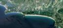
UPDATE: With a big hat tip to Korea Beat, I have located the new Majon Hotel in North Korea. See a satellite picture of it here. Here are some pictures of the inside c/o the Choson Ilbo.
ORIGINAL POST:
According to the Choson Ilbo:
North Korea on Monday celebrated the completion of what it has hailed as a “world-class” hotel in the Majon resort area in Hamhung, South Hamgyong Province, North Korean Central Broadcasting reported Tuesday.
The broadcast said the Majon Hotel “is equipped with top-class accommodation and recreation facilities such as an indoor swimming pool, a steam sauna, a public bath, and even a beach resort.”
Although it did not specify the size, the broadcast called the hotel a “creation that illuminates the era of the Korean Workers’ Party,” suggesting it is relatively luxurious.
The completion ceremony was attended by key leaders of the party, the government and the military, including People’s Armed Forces Minister Kim Yong-chun, party Secretaries Kim Ki-nam and Choe Thae-bok, and Prime Minister Kim Yong-il.
In a congratulatory speech, Kim Ki-nam said the hotel was “another proud creation built thanks to leader Kim Jong-il’s love of the people in the military-first era.”
The Majon resort area where the hotel is located is famous throughout North Korea. It has a sandy beach park 6 km long and 50-100 m wide along the east coast and 16 recreational buildings, 13 public buildings, and a boy scout camp — all on an area measuring some 3 million sq. m.
Here is the official KCNA press coverage:
Majon Hotel Completed
Pyongyang, July 28 (KCNA) — Modern Majon Hotel sprang up at the Majon recreation ground in Hamhung City, a good destination of holiday makers.
The hotel has all modern cultural and welfare facilities such as bedrooms of various sizes and styles, restaurants, indoor swimming pool, saunas and bath facilities. It has also a bathing resort. This is another edifice to be proud of in the era of Songun, a product of General Secretary Kim Jong Il’s love for the people as he has always worked hard to provide people with better conditions for their recreation.
A ceremony for the completion of the hotel was held on the spot on Monday.
Present there were Premier Kim Yong Il, Minister of the People’s Armed Forces Kim Yong Chun, Secretaries of the Central Committee of the Workers’ Party of Korea Choe Thae Bok and Kim Ki Nam, department directors of the C.C., WPK, officials concerned and employees of the hotel.
Kim Ki Nam in his speech at the ceremony underscored the need for the staff of the hotel to steadily improve the service so that Kim Jong Il’s boundless love may reach people as quickly as possible.
At the end of the ceremony the participants looked round the interior and exterior of the hotel.
Here is the location of the beach. Some travelers have been there, but photos of the area remain scarce. If anyone comes across a photo of the hotel, or can identify the exact location, please let me know. Parts of the beach and surroundings are still not in high resolution on Google Earth, so this also complicates the discovery of the hotel’s location.
Read the full stories here:
N.Korea Completes ‘Luxury’ Resort Hotel
Choson Ilbo
7/29/2009
KCNA
Posted in Central Committee, Google Earth, Hoteling, Leisure, Military, Tourism | 4 Comments »
Wednesday, March 11th, 2009
North Korea Uncovered v.16
Download it here
The most recent version of North Korea Uncovered (North Korea Google Earth) has been published. Since being launched, this project has been continuously expanded and to date has been downloaded over 32,000 times.
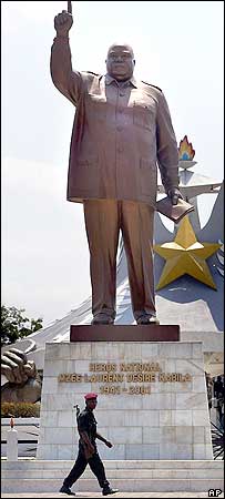
Pictured to the left is a statue of Laurent Kabila of the Democratic Republic of Congo. This statue, as well as many others identified in this version of the project, was built by the North Koreans. According to a visitor:
From the neck down, the Kabila monument looks strangely like Kim Jong Il: baggy uniform, creased pants, the raised arm, a little book in his left hand. From the neck up, the statue is the thick, grim bald mug of Laurent Kabila (his son Joseph is the current president). “The body was made in North Korea,” explains my driver Felix. In other words, the body is Kim Jong Il’s, but with a fat, scowling Kabila head simply welded on.
This is particularly interesting because there are no known pictures of a Kim Jong il statue. The only KJI statue that is reported to exist is in front of the National Security Agency in Pyongyang. If a Kim Jong il statue does in fact exist, it might look something like this.
Thanks again to the anonymous contributors, readers, and fans of this project for your helpful advice and location information. This project would not be successful without your contributions.
Version 16 contains the following additions: Rakwon Machine Complex, Sinuiju Cosmetics Factory, Manpo Restaurant, Worker’s Party No. 3 Building (including Central Committee and Guidance Dept.), Pukchang Aluminum Factory, Pusan-ri Aluminum Factory, Pukchung Machine Complex, Mirim Block Factory, Pyongyang General Textile Factory, Chonnae Cement Factory, Pyongsu Rx Joint Venture, Tongbong Cooperative Farm, Chusang Cooperative Farm, Hoeryong Essential Foodstuff Factory, Kim Ki-song Hoeryong First Middle School , Mirim War University, electricity grid expansion, Tonghae Satellite Launching Ground (TSLG)” is also known as the “Musudan-ri Launching Station,” rebuilt electricity grid, Kumchang-ri suspected underground nuclear site, Wangjaesan Grand Monument, Phothae Revolutionary Site, Naedong Revolutionary Site, Kunja Revolutionary Site, Junggang Revolutionary Site, Phophyong Revolutionary Site, Samdung Revolutionary Site, Phyongsan Granite Mine, Songjin Iron and Steel Complex (Kimchaek), Swedish, German and British embassy building, Taehongdan Potato Processing Factory, Pyongyang Muyseum of Film and Theatrical Arts, Overseas Monuments built by DPRK: Rice Museum (Muzium Padi) in Malaysia, Statue de Patrice Lumumba (Kinshasa, DR Congo), National Heroes Acre (Windhoek, Namibia), Derg Monument (Addis Ababa, Ethiopia), National Heroes Acre (Harare, Zimbabwe), New State House (Windhoek, Namibia), Three Dikgosi (Chiefs) Monument (Gaborone, Botswana), 1st of May Square Statue of Agostinho Neto (Luanda, Angola), Momunment Heroinas Angolas (Luanda, Angola), Monument to the Martyrs of Kifangondo Battle (Luanda, Angola), Place de l’étoile rouge, (Porto Novo, Benin), Statue of King Béhanzin (Abomey, Benin), Monument to the African Renaissance (Dakar, Senegal), Monument to Laurent Kabila [pictured above] (Kinshasa, DR Congo).
Posted in Agriculture, Architecture, Art, Automobiles, Aviation, Banking, Coal, Communications, Computing/IT, Construction, Dams/hydro, Education, Electricity, Energy, Environmental protection, Figure skating, Film, Finance, Fiscal & monetary policy, Food, Football (soccer), Forestry, Gambling, Gasoline, General markets (FMR: Farmers Market), Golf, Google Earth, Health care, Hoteling, Hwanggumphyong and Wihwado Economic Zones (Sinuiju), Intranet, Kaesong Industrial Complex (KIC), Leisure, Library, Light Industry, Mansudae Overseas Development Group, Manufacturing, Mass games, Military, Mining/Minerals, Mt. Kumgang Tourist Special Zone, Music, Nuclear, Oil, Pyongyang Metro, Railways, Rason Economic and Trade Zone (Rajin-Sonbong), Real estate, Religion, Restaurants, Sea shipping, Special Economic Zones (Established before 2013), Sports, Telephones, Television, Tourism, Transportation, Water, Wind | 10 Comments »
Thursday, October 2nd, 2008
North Korea Uncovered: Version 12
Download it here
 About this Project: This map covers North Korea’s agriculture, aviation, cultural locations, markets, manufacturing facilities, energy infrastructure, political facilities, sports venues, military establishments, religious facilities, leisure destinations, national parks, shipping, mining, and railway infrastructure. It is continually expanding and undergoing revisions. This is the 12th version.
Additions include: Tongch’ang-dong launch facility overlay (thanks to Mr. Bermudez), Yongbyon overlay with destroyed cooling tower (thanks to Jung Min Noh), “The Barn” (where the Pueblo crew were kept), Kim Chaek Taehung Fishing Enterprise, Hamhung University of education, Haeju Zoo, Pyongyang: Kim il Sung Institute of Politics, Polish Embassy, Munsu Diplomatic Store, Munsu Gas Station, Munsu Friendship Restaurant, Mongolian Embassy, Nigerian Embassy, UN World Food Program Building, CONCERN House, Czech Republic Embassy, Rungnang Cinema, Pyongyang University of Science and Technology, Pyongyang Number 3 Hospital, Electric Machines Facotry, Bonghuajinlyoso, Second National Academy of Sciences, Central Committee Building, Party Administration Building, Central Statistics Bureau, Willow Capital Food House, Thongounjong Pleasure Ground, Onpho spa, Phipa Resort Hotel, Sunoni Chemical Complex (east coast refinery), Ponghwa Chemical complex (west coast refinery), Songbon Port Revolutionary Monument, Hoeryong People’s Library, Pyongyang Monument to the anti Japanese martyrs, tideland reclamation project on Taegye Island. Additionally the electricity grid was expanded and the thermal power plants have been better organized. Additional thanks to Ryan for his pointers.
I hope this map will increase interest in North Korea. There is still plenty more to learn, and I look forward to receiving your contributions to this project.
Version 12 available: Download it here
Posted in Agriculture, Animation, Architecture, Art, Automobiles, Aviation, Banking, Cell phones, Coal, Communications, Computing/IT, Construction, Copper, Dams/hydro, Education, Electricity, Energy, Environmental protection, Film, Finance, Fiscal & monetary policy, Food, Football (soccer), Foreign direct investment, Forestry, Gambling, Gasoline, General markets (FMR: Farmers Market), Gold, Golf, Google Earth, Health care, Hoteling, Hwanggumphyong and Wihwado Economic Zones (Sinuiju), International trade, Joint Ventures, Kaesong Industrial Complex (KIC), Leisure, Library, Light Industry, Lumber, Manufacturing, Mass games, Military, Mining/Minerals, Mt. Kumgang Tourist Special Zone, Music, Nuclear, Pyongyang Metro, Railways, Rason Economic and Trade Zone (Rajin-Sonbong), Real estate, Religion, Restaurants, Sea shipping, Special Economic Zones (Established before 2013), Sports, Television, Tourism, Transportation, Wind | 1 Comment »
Thursday, August 14th, 2008
The most authoritative map of North Korea on Google Earth
Download it here
 This map covers North Korea’s agriculture, aviation, cultural locations, markets, manufacturing facilities, railroad, energy infrastructure, politics, sports venues, military establishments, religious facilities, leisure destinations, and national parks. It is continually expanding and undergoing revisions. This is the eleventh version.
Additions include: Mt. Paegun’s Ryonghung Temple and resort homes, Pyongyang’s Chongryu Restaurant, Swiss Development Agency (former UNDP office), Iranian Embassy, White Tiger Art Studio, KITC Store, Kumgangsan Store, Pyongyang Fried Chicken Restaurant, Kilju’s Pulp Factory (Paper), Kim Chaek Steel Mill, Chongjin Munitions Factory, Poogin Coal Mine, Ryongwun-ri cooperative farm, Thonggun Pavilion (Uiju), Chinju Temple (Yongbyon), Kim il Sung Revolutionary Museum (Pyongsong), Hamhung Zoo, Rajin electrified perimeter fence, Pyongsong market (North Korea’s largest), Sakju Recreation Center, Hoeryong Maternity Hospital, Sariwon Suwon reservoir (alleged site of US massacre), Sinpyong Resting Place, 700 Ridges Pavilion, Academy of Science, Hamhung Museum of the Revolutionary Activities of Comrade Kim Il Sung, South Hamgyong House of Culture, Hamhung Royal Villa, Pork Chop Hill, and Pyongyang’s Olympic torch route. Additional thanks go to Martyn Williams for expanding the electricity grid, particularly in Samjiyon, and various others who have contributed time improving this project since its launch.
Disclaimer: I cannot vouch for the authenticity of many locations since I have not seen or been to them, but great efforts have been made to check for authenticity. These efforts include pouring over books, maps, conducting interviews, and keeping up with other peoples’ discoveries. In many cases, I have posted sources, though not for all. This is a thorough compilation of lots of material, but I will leave it up to the reader to make up their own minds as to what they see. I cannot catch everything and I welcome contributions. Additionally, this file is getting large and may take some time to load.
Posted in Advertising, Agriculture, Architecture, Art, Automobiles, Aviation, Banking, Biotech, Cell phones, Central Broadcasting Station, Coal, Committee for Cultural Relations with Foreign Countries, Communications, Computing/IT, Construction, Dams/hydro, Demographics, Domestic publication, Education, Electricity, Energy, Environmental protection, Film, Finance, Food, Football (soccer), Foreign direct investment, Forestry, Gambling, Gasoline, General markets (FMR: Farmers Market), Golf, Google Earth, Health care, Hoteling, Hwanggumphyong and Wihwado Economic Zones (Sinuiju), Intranet, Joint Ventures, Kaesong Industrial Complex (KIC), Kim Il Sung University, Korean Buddhist Association, Labor conditions/wages, Leisure, Library, Light Industry, Lumber, Mansu Art Studio, Manufacturing, Mass games, Maternity Hospital, Military, Mining/Minerals, Ministry of foreign Affairs, Ministry of Foreign Trade, Ministry of People’s Armed Forces, Ministry of Post and Telecommunications, Ministry of Public Health, Mt. Kumgang Tourist Special Zone, Musan Mine, Nuclear, Oil, Phoenix Commerical Ventures, Pyongyang Embroidery Institute, Pyongyang Film Studio, Pyongyang International Information Center of New Techn, Pyongyang International Trade Fair, Pyongyang Metro, Pyongyang University of Medicine, Radio, Railways, Rason Economic and Trade Zone (Rajin-Sonbong), Real estate, Religion, Restaurants, Sea shipping, Sports, Steel, Supreme Peoples Assembly, Tourism, Transportation, Wind | 6 Comments »
Friday, January 11th, 2008
Daily NK
Moon Sung Hwee
1/11/2008
Rodong Sinmun, the official mouthpiece of the Chosun (North Korea) Workers Party, discussed the construction of new electrical infrastructure in Samjiyeon in a feature titled, “The New Legend from the Night-less City, Samjiyeon,” on December 26.
Rodong Sinmun praised Samjiyeon’s current condition, saying that “It is literally a night-less city where countless lights from houses and streetlights along the beltway shine like stars.”
The newspaper implied that providing electricity to hotels and other lodging for visitors was the reason for setting up the electrical infrastructure, noting that “Visitors who have completed long distance marches would want to take a rest, sing songs, and play accordions in the heated rooms of lodgings by the lake of Samjiyeon.”
The newspaper revealed, “The electricity produced by the Samsoo Power Plant, which was completed in May 2007, is now flowing to Samjiyeon.”
It added, “The June 18 Shock Brigade and workers form the Ministry of Electric Power pursued the lofty goals of the great General to expand the electrical infrastructure of the Mt. Baekdu region. They provided materials and equipment for the construction of power-transmission wires and towers and built them.”
To accomplish the goal of the North Korean authorities, in there words: “to improve the hometown of the General to meet global standards” – the Propaganda and Agitation Department organized the “Shock Brigade for the Propagation of the Party Ideology” (June 18 Shock Brigade) and made the brigade tear down houses and start reconstructing the city.
Although North Korean authorities said that they redeveloped the Samjiyeon district for the purpose of restoring Kim Jong Il’s hometown, a rumor is spreading among cadres that this reconstruction project was actually carried out in preparation for the commencement of Mt. Baekdu tours for South Koreans, according to inside sources.
In 1998, when the North and Hyundai Asan started Mt. Geumgang’s tour business, they agreed that Hyundai would offer 942 million dollars to the North in return for the right to use the tour site and to run the tour business for 30 years. Similar preparations to the ones being made in Samyijeon were completed prior to the opening of the Geumgang site.
It appears that North Korea has been carrying out construction work in Samjiyeon since 2001. Experts point out that reconstruction of the houses in the area was inevitable because these sites would soon be revealed to South Korean tourists.
North Korean authorities stressed that the newly-built houses are on par with international standards but residents complain of insufficient electrical supplies, according to the inside sources.
Sources said that the power situation was so dire that residents are forced to cook outdoors and bring heated stones in their houses for heating.
Posted in Civil society, Electricity, Energy, Leisure | Comments Closed
Saturday, October 6th, 2007
Version 5: Download it here (on Google Earth)
This map covers North Korea’s agriculture, aviation, cultural locations, manufacturing facilities, railroad, energy infrastructure, politics, sports venues, military establishments, religious facilities, leisure destinations, and national parks. It is continually expanding and undergoing revisions. This is the fifth version.
Additions to the latest version of “North Korea Uncovered” include updates to new Google Earth overlays of Sinchon, UNESCO sites, Railroads, canals, and the DMZ, in addition to Kim Jong Suk college of eduation (Hyesan), a huge expansion of the electricity grid (with a little help from Martyn Williams) plus a few more parks, antiaircraft sites, dams, mines, canals, etc.
Disclaimer: I cannot vouch for the authenticity of many locations since I have not seen or been to them, but great efforts have been made to check for authenticity. These efforts include pouring over books, maps, conducting interviews, and keeping up with other peoples’ discoveries. In many cases, I have posted sources, though not for all. This is a thorough compilation of lots of material, but I will leave it up to the reader to make up their own minds as to what they see. I cannot catch everything and I welcome contributions.
I hope this map will increase interest in North Korea. There is still plenty more to learn, and I look forward to receiving your additions to this project.
Posted in 1990s Famine, Advertising, Agriculture, Architecture, Arduous March, Art, Automobiles, Aviation, Banking, Civil society, Coal, Communications, Computing/IT, Cosmetics, Dams/hydro, DPRK organizations, Economic reform, Education, Electricity, Energy, Environmental protection, Film, Finance, Fiscal & monetary policy, Football (soccer), Foreign direct investment, Forestry, Gambling, Gasoline, General markets (FMR: Farmers Market), Golf, Google Earth, Health care, Hoteling, Hwanggumphyong and Wihwado Economic Zones (Sinuiju), Illicit activities, Juche, Kaesong Industrial Complex (KIC), Labor conditions/wages, Leisure, Library, Light Industry, Manufacturing, Mass games, Military, Mining/Minerals, Mt. Kumgang Tourist Special Zone, Music, Nuclear, Political economy, Pyongyang International Trade Fair, Pyongyang Metro, Radio, Railways, Rason Economic and Trade Zone (Rajin-Sonbong), Real estate, Religion, Restaurants, Sea shipping, Special Economic Zones (Established before 2013), Television, Tourism, Transportation, Water, Worker's Party | 2 Comments »
Wednesday, August 29th, 2007
The most authoritative, publicly available map of North Korea
Version 4: August 29, 2007
Download it here
This map covers North Korea’s agriculture, aviation, cultural locations, manufacturing facilities, railroad, energy infrastructure, politics, sports venues, military establishments, religious facilities, leisure destinations, and national parks. It is continually expanding and undergoing revisions. This is the fourth version.
Additions to the latest version of “North Korea Uncovered” include the city of Manpo along the Chinese border, KEDO, Kumgang Resort expansion, Kaesong Industrial Zone, as well as a few more parks, antiaircraft sites, dams, mines, canals, etc. I have also added more links in the menu which will tell the viewer a bit about the locations themselves. I have also changed the color scheme to make the collage easier to view.
Disclaimer: I cannot vouch for the authenticity of many locations since I have not seen or been to them, but great efforts have been made to check for authenticity. These efforts include pouring over books, maps, conducting interviews, and keeping up with other peoples’ discoveries. In many cases, I have posted sources, though not for all. This is a thorough compilation of lots of material, but I will leave it up to the reader to make up their own minds as to what they see. I cannot catch everything and I welcome contributions.
I hope this map will increase interest in North Korea. There is still plenty more to learn, and I look forward to receiving your additions to this project.
Posted in Agriculture, Architecture, Automobiles, Aviation, Biotech, Dams/hydro, Education, Electricity, Energy, Environmental protection, Fiscal & monetary policy, Forestry, Gasoline, General markets (FMR: Farmers Market), Google Earth, Health care, Hoteling, Hwanggumphyong and Wihwado Economic Zones (Sinuiju), International trade, Kaesong Industrial Complex (KIC), Labor conditions/wages, Leisure, Library, Light Industry, Lumber, Manufacturing, Military, Mining/Minerals, Mt. Kumgang Tourist Special Zone, Political economy, Pyongyang International Trade Fair, Pyongyang Metro, Railways, Rason Economic and Trade Zone (Rajin-Sonbong), Real estate, Sea shipping, Special Economic Zones (Established before 2013), Tourism, Transportation, Water, Wind | 1 Comment »
Tuesday, July 31st, 2007
Now available on Google Earth!
(click above to download to your own Google Earth)
North Korea Uncovered v.3
Google Earth added a high-resolution overlay of the area between Pyongyang and Nampo. In it, most of the Koguryo tombs listed with UNESCO are now distinguishable. In addition, viewers can see the latest Kim Jong Il palace (including a yacht), the DPRK’s premier golf course, and the Chinese-built Taean Glass factory. I have also made some progress in mapping out the DPRK electricity grid.
This is the most authoritative map of North Korea that exists publicly today. Agriculture, aviation, cultural institutions, manufacturing, railroad, energy, politics, sports, military, religion, leisure, national parks…they are all here, and will captivate anyone interested in North Korea for hours.
Naturally, I cannot vouch for the authenticity of many locations since I have not seen or been to them, but great efforts have been made to check for authenticity. In many cases, I have posted sources, though not for all. This is a thorough compilation of lots of material, but I will leave it up to the reader to make up their own minds on the more “controversial” locations. In time, I hope to expand this further by adding canal and road networks.
I hope this post will launch a new interest in North Korea. There is still plenty more to learn, and I look forward to hearing about improvements that can be made.
Posted in Architecture, Automobiles, Aviation, Banking, Coal, Communications, Computing/IT, Dams/hydro, Education, Electricity, Energy, Football (soccer), Forestry, Gambling, Gasoline, General markets (FMR: Farmers Market), Golf, Google Earth, Health care, Hoteling, Hwanggumphyong and Wihwado Economic Zones (Sinuiju), Kaesong Industrial Complex (KIC), Leisure, Library, Light Industry, Manufacturing, Mass games, Military, Mining/Minerals, Mt. Kumgang Tourist Special Zone, Railways, Rason Economic and Trade Zone (Rajin-Sonbong), Real estate, Religion, Restaurants, Sea shipping, Sports, Tourism, Transportation | 1 Comment »
