Archive for the ‘Google Earth’ Category
Friday, December 7th, 2007

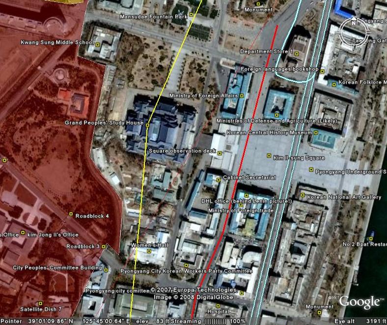
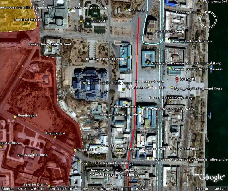
Click on the image to see a larger picture. Google Earth Coordinates: 38.374935°, 127.103343°
As many readers know, I have been mapping out North Korea on Google Earth for some time. I have found numerous propaganda slogans displayed on hills and mountainsides throughout the country, but this recent discovery is by far the best example. I would like to see this carving from the ground, so if anyone has pictures, please send them to me.
Posted in Google Earth, Mt. Kumgang Tourist Special Zone, Political economy | Comments Closed
Sunday, November 11th, 2007
The most authoritative map of North Korea on Google Earth
North Korea Uncovered: Version 6
Download it here
 This map covers North Korea’s agriculture, aviation, cultural locations, manufacturing facilities, railroad, energy infrastructure, politics, sports venues, military establishments, religious facilities, leisure destinations, and national parks. It is continually expanding and undergoing revisions. This is the sixth version.
Additions to the newest version of North Korea Uncovered include: Alleged Syrian nuclear site (before and after bombing), Majon beach resort, electricity grid expansion, Runga Island in Pyongyang, Mt. Ryongak, Yongbyon historical fort walls, Suyang Fort walls and waterfall in Haeju, Kaechon-Lake Taesong water project, Paekma-Cholsan waterway, Yachts (3), and Hyesan Youth Copper Mine.
Disclaimer: I cannot vouch for the authenticity of many locations since I have not seen or been to them, but great efforts have been made to check for authenticity. These efforts include pouring over books, maps, conducting interviews, and keeping up with other peoples’ discoveries. In many cases, I have posted sources, though not for all. This is a thorough compilation of lots of material, but I will leave it up to the reader to make up their own minds as to what they see. I cannot catch everything and I welcome contributions.
Posted in Advertising, Agriculture, Architecture, Automobiles, Aviation, Banking, Black markets, Committee for Cultural Relations with Foreign Countries, Communications, Computing/IT, Dams/hydro, Department Store No. 1, Economic reform, Education, Electricity, Energy, Environmental protection, Film, Finance, Fiscal & monetary policy, Football (soccer), Forestry, Gambling, Gasoline, General markets (FMR: Farmers Market), Golf, Google Earth, Hana Electronics Company, Health care, Hoteling, Hwanggumphyong and Wihwado Economic Zones (Sinuiju), Hyesan Youth Cooper Mine, Kaesong Industrial Complex (KIC), Kim Il Sung University, Korea Computer Center (KCC), Library, Light Industry, Mansudae creative Company (art studio), Manufacturing, Mass games, Maternity Hospital, Military, Mining/Minerals, Ministry of Culture, Ministry of Foreign Trade, Mt. Kumgang Tourist Special Zone, Musan Mine, Music, Nuclear, Pyongyang Embroidery Institute, Pyongyang Film Studio, Pyongyang Informatics Center (PIC), Pyongyang International Information Center of New Techn, Pyongyang International Trade Fair, Pyongyang Metro, Railways, Rason Economic and Trade Zone (Rajin-Sonbong), Real estate, Religion, Restaurants, Sea shipping, Special Economic Zones (Established before 2013), Sports, Steel, Supreme Peoples Assembly, Television, Tourism, Transportation, Water, Wind | Comments Closed
Saturday, October 6th, 2007
Version 5: Download it here (on Google Earth)
This map covers North Korea’s agriculture, aviation, cultural locations, manufacturing facilities, railroad, energy infrastructure, politics, sports venues, military establishments, religious facilities, leisure destinations, and national parks. It is continually expanding and undergoing revisions. This is the fifth version.
Additions to the latest version of “North Korea Uncovered” include updates to new Google Earth overlays of Sinchon, UNESCO sites, Railroads, canals, and the DMZ, in addition to Kim Jong Suk college of eduation (Hyesan), a huge expansion of the electricity grid (with a little help from Martyn Williams) plus a few more parks, antiaircraft sites, dams, mines, canals, etc.
Disclaimer: I cannot vouch for the authenticity of many locations since I have not seen or been to them, but great efforts have been made to check for authenticity. These efforts include pouring over books, maps, conducting interviews, and keeping up with other peoples’ discoveries. In many cases, I have posted sources, though not for all. This is a thorough compilation of lots of material, but I will leave it up to the reader to make up their own minds as to what they see. I cannot catch everything and I welcome contributions.
I hope this map will increase interest in North Korea. There is still plenty more to learn, and I look forward to receiving your additions to this project.
Posted in 1990s Famine, Advertising, Agriculture, Architecture, Arduous March, Art, Automobiles, Aviation, Banking, Civil society, Coal, Communications, Computing/IT, Cosmetics, Dams/hydro, DPRK organizations, Economic reform, Education, Electricity, Energy, Environmental protection, Film, Finance, Fiscal & monetary policy, Football (soccer), Foreign direct investment, Forestry, Gambling, Gasoline, General markets (FMR: Farmers Market), Golf, Google Earth, Health care, Hoteling, Hwanggumphyong and Wihwado Economic Zones (Sinuiju), Illicit activities, Juche, Kaesong Industrial Complex (KIC), Labor conditions/wages, Leisure, Library, Light Industry, Manufacturing, Mass games, Military, Mining/Minerals, Mt. Kumgang Tourist Special Zone, Music, Nuclear, Political economy, Pyongyang International Trade Fair, Pyongyang Metro, Radio, Railways, Rason Economic and Trade Zone (Rajin-Sonbong), Real estate, Religion, Restaurants, Sea shipping, Special Economic Zones (Established before 2013), Television, Tourism, Transportation, Water, Worker's Party | 2 Comments »
Wednesday, August 29th, 2007
The most authoritative, publicly available map of North Korea
Version 4: August 29, 2007
Download it here
This map covers North Korea’s agriculture, aviation, cultural locations, manufacturing facilities, railroad, energy infrastructure, politics, sports venues, military establishments, religious facilities, leisure destinations, and national parks. It is continually expanding and undergoing revisions. This is the fourth version.
Additions to the latest version of “North Korea Uncovered” include the city of Manpo along the Chinese border, KEDO, Kumgang Resort expansion, Kaesong Industrial Zone, as well as a few more parks, antiaircraft sites, dams, mines, canals, etc. I have also added more links in the menu which will tell the viewer a bit about the locations themselves. I have also changed the color scheme to make the collage easier to view.
Disclaimer: I cannot vouch for the authenticity of many locations since I have not seen or been to them, but great efforts have been made to check for authenticity. These efforts include pouring over books, maps, conducting interviews, and keeping up with other peoples’ discoveries. In many cases, I have posted sources, though not for all. This is a thorough compilation of lots of material, but I will leave it up to the reader to make up their own minds as to what they see. I cannot catch everything and I welcome contributions.
I hope this map will increase interest in North Korea. There is still plenty more to learn, and I look forward to receiving your additions to this project.
Posted in Agriculture, Architecture, Automobiles, Aviation, Biotech, Dams/hydro, Education, Electricity, Energy, Environmental protection, Fiscal & monetary policy, Forestry, Gasoline, General markets (FMR: Farmers Market), Google Earth, Health care, Hoteling, Hwanggumphyong and Wihwado Economic Zones (Sinuiju), International trade, Kaesong Industrial Complex (KIC), Labor conditions/wages, Leisure, Library, Light Industry, Lumber, Manufacturing, Military, Mining/Minerals, Mt. Kumgang Tourist Special Zone, Political economy, Pyongyang International Trade Fair, Pyongyang Metro, Railways, Rason Economic and Trade Zone (Rajin-Sonbong), Real estate, Sea shipping, Special Economic Zones (Established before 2013), Tourism, Transportation, Water, Wind | 1 Comment »
Tuesday, July 31st, 2007
Now available on Google Earth!
(click above to download to your own Google Earth)
North Korea Uncovered v.3
Google Earth added a high-resolution overlay of the area between Pyongyang and Nampo. In it, most of the Koguryo tombs listed with UNESCO are now distinguishable. In addition, viewers can see the latest Kim Jong Il palace (including a yacht), the DPRK’s premier golf course, and the Chinese-built Taean Glass factory. I have also made some progress in mapping out the DPRK electricity grid.
This is the most authoritative map of North Korea that exists publicly today. Agriculture, aviation, cultural institutions, manufacturing, railroad, energy, politics, sports, military, religion, leisure, national parks…they are all here, and will captivate anyone interested in North Korea for hours.
Naturally, I cannot vouch for the authenticity of many locations since I have not seen or been to them, but great efforts have been made to check for authenticity. In many cases, I have posted sources, though not for all. This is a thorough compilation of lots of material, but I will leave it up to the reader to make up their own minds on the more “controversial” locations. In time, I hope to expand this further by adding canal and road networks.
I hope this post will launch a new interest in North Korea. There is still plenty more to learn, and I look forward to hearing about improvements that can be made.
Posted in Architecture, Automobiles, Aviation, Banking, Coal, Communications, Computing/IT, Dams/hydro, Education, Electricity, Energy, Football (soccer), Forestry, Gambling, Gasoline, General markets (FMR: Farmers Market), Golf, Google Earth, Health care, Hoteling, Hwanggumphyong and Wihwado Economic Zones (Sinuiju), Kaesong Industrial Complex (KIC), Leisure, Library, Light Industry, Manufacturing, Mass games, Military, Mining/Minerals, Mt. Kumgang Tourist Special Zone, Railways, Rason Economic and Trade Zone (Rajin-Sonbong), Real estate, Religion, Restaurants, Sea shipping, Sports, Tourism, Transportation | 1 Comment »
Sunday, April 22nd, 2007
DOWNLOAD IT HERE (to your own Google Earth)
Using numerous maps, articles, and interviews I have mapped out North Korea by “industry” (or topic) on Google Earth. This is the most authoritative map of North Korea that exists publicly today.
Agriculture, aviation, cultural, manufacturing, railroad, energy, politics, sports, military, religion, leisure, national parks…they are all here, and will captivate anyone interested in North Korea for hours.
Naturally, I cannot vouch for the authenticity of many locations since I have not seen or been to them, but great efforts have been made to check for authenticity. In many cases, I have posted sources, though not for all. This is a thorough compilation of lots of material, but I will leave it up to the reader to make up their own minds on the more “controversial” locations. In time, I hope to expand this further by adding canal and road networks.
I hope this post will launch a new interest in North Korea. There is still plenty more to learn, and I look forward to hearing about improvements that can be made.
Posted in Agriculture, Coal, Communications, Dams/hydro, DPRK organizations, Education, Electricity, Energy, Football (soccer), Forestry, Gambling, Golf, Google Earth, Health care, Hoteling, Manufacturing, Mass games, Military, Mining/Minerals, Nuclear, Railways, Religion, Restaurants, Sports, Tourism, Transportation, Worker's Party | 5 Comments »
Tuesday, December 19th, 2006
Using various maps, legends and available photos, I have mapped out the entire North Korean railway system. Interesting highlights include special railway lines to large palaces in Sinuiju and on the east coast, the collection of railway lines around coal mines in the center of the country, and the railway line in Kaesong that crosses the DMZ to South Korea.
Download it to your own Google Earth here
Posted in Google Earth, Railways | 2 Comments »
Sunday, November 19th, 2006
I just got back from visiting Turkmenistan with Koryo Tours. I had a great time and have managed to identify most of the things I saw on Google Earth. If you would like to live my vacation (via satelite images that are a couple of years old) click here (Updated on 12/30/2006) to download them onto your own Google Earth.
-Curtis
Posted in Google Earth | 1 Comment »

