Archive for the ‘Google Earth’ Category
Friday, July 25th, 2008
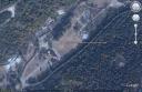
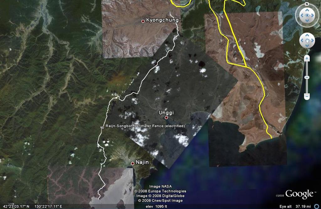
According to Lankov and Kim’s “North Korean Market Vendors: The Rise of Grassroots Capitalists in a Post-Stalinist Society” there is an electrified perimeter fence surrounding North Korea’s first “special economic zone,” Rajin Songbon.
I have spent a lot of time looking at this area on Google Earth, but never seen the electrified fence. Last night, however, I found it. Before reading Lankov’s article, I thought it was a highway, or highway construction, on account of its approximate 35 mile/56 km length (as calculated using the Google Earth ruler). The image of the perimeter (shown below) will be added, along with a few other new locations, to the next version of North Korea Uncovered (due in early August).
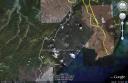
Click on image for larger version
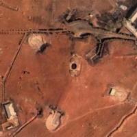
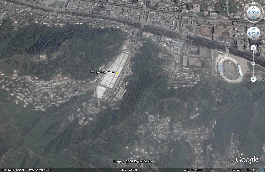
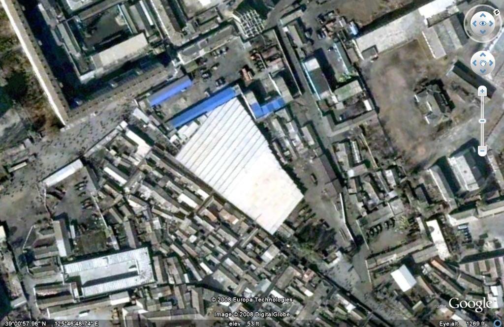
And in case you missed it, Lankov’s article mentions North Korea’s largest market in Pyongsong. Satellite imagery of this location is below.
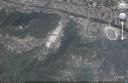
Click on image for larger view
Posted in Automobiles, Electricity, Energy, Google Earth, Rason Economic and Trade Zone (Rajin-Sonbong), Special Economic Zones (Established before 2013), Transportation | 3 Comments »
Wednesday, July 23rd, 2008
“North Korean Market Vendors: The Rise of Grassroots Capitalists in a Post-Stalinist Society”
Andrei Lankov and Kim Seok-hyang
Pacific Affairs, Vol. 81 Iss.1
(subscription required)
Abstract:
The article deals with the social changes that have taken place in North Korea [from 1994-2002], when the collapse of the centrally planned economy led to the growth of private commercial activity. This activity remains technically illegal, but the relevant bans and restrictions have rarely been enforced due to endemic corruption and disorganization of the state bureaucracy. The article is largely based on in-depth interviews with North Korean black market operators [who have defected to South Korea]. It traces their origins, the type and scale of their business, and changes in their mode of operation.
The article demonstrates that the “second economy” came to dominate North Korean economic life by the late 1990s, since authorities’ attempts to limit its scale were largely ineffective. The growth of the “second economy” produced new grassroots capitalists who sometimes came from underpriveledged social groups, but more typically represented people with good official connections. It is also remarkable that foreign connections (usually with China) played a major role: to a large extent, merchandise sold at the North Korean markets either came from overseas or was exported overseas eventually, and in many cases the merchants’ initial capital was also provided by relatives residing overseas.
Some highlights:
1. Changsa is the North Korean word for “dealings in the marketplace.” Tonju is the word for money changers/lenders meaning “master of money”.
2. Public Distribution System (PDS) rations were cut for the first time in 1973.
3. The DPRK system restricted market activity primarily through three mechanisms: limited size of family farming plots, inminban surveillance system, and travel permits.
4. Before the arduous march, North Koreans were not inclined to resort to market trade. These transactions were seen as ethically suspect. Once the famine hit, people took up market trading remarkably quickly.
5. Before the arduous march, bribery was rare, even though patronage and indirect forms of corruption were rampant. Mid-level bureaucrats had to vie for preferred access to poor-quality consumer goods, better schools, and study trips abroad.
6. At the height of the arduous march (1997), production was at 46% of capacity.
7. North Korean traders seldom if ever have to deal with the protection racket. When asked directly, respondents did not mention threats from mobsters as one of their security concerns (I wonder if this is still the case).
8. Pyongsong market is reputed to be the largest in the country. It is just outside Pyongyang, making it accessible to citizens inside the capital as well as those who cannot get permits to enter the city (Pictured below with Google Earth coordinates).
Click on image for larger view
9. Financial services such as money-changers and private loan sharks offer loans at 5%-30%/month.
10. Most North Korean merchants know South Korea is a rich country. They also avoid surveillance since these activities are done at state-owned enterprises and study sessions.
Posted in Automobiles, Banking, Black markets, Economic reform, Finance, Fiscal & monetary policy, Foreign direct investment, Google Earth, Insurance, Joint Ventures, Price liberalization, Private property, Public Distribiution System (PDS), Railways, Transportation | 1 Comment »
Wednesday, June 11th, 2008
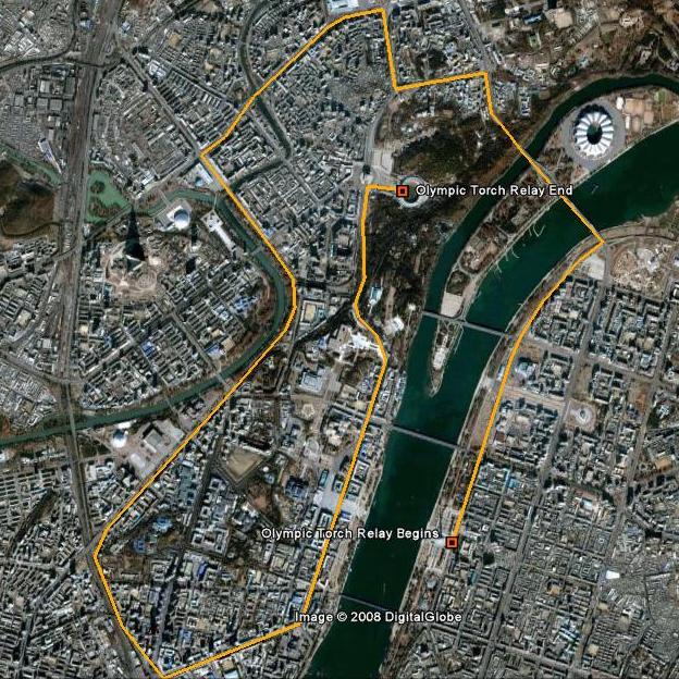
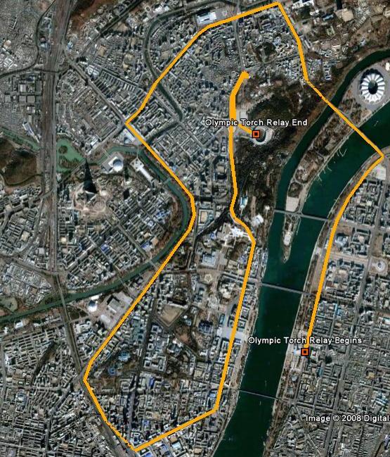
(Click on image for larger view)
Using Naenara and a Chinese language news broadcast, I pieced together Pyongang’s 2008 Olympic torch relay route.
UPDATED: 6/25/2008
The relay began at the Juche Tower and passed by the Golden Lanes Bowling Alley, East Pyongyang Theater (where NY Phil played) and crossed Chongnyu Bridge to West Pyongyang. Here it passed the Friendship Tower (commemorating Chinese support in the Korean War), Chinese Embassy, Immortal Tower of Kim il Sung, Victorious Fatherland Liberation War Museum, Pothong River Gate, Central Train Station, Kim il Sung Square, Mansu Hill, Chollima Statue, Arch of Triumph, and finished at Kim il Sung Stadium where the relay ended.
More on the torch relay can be found here.
This will be included in the next version of North Korea Uncovered (Goolge Earth).
Posted in Google Earth, Sports | Comments Closed
Wednesday, May 28th, 2008
UPDATE: The Kumgangsan Golf Course is located here (Wikimapia), though it is still under construction in these dated images.
ORIGINAL POST: The DPRK’s golf facilities are all easily recognizable from Google Earth: There is the 18 hole course half-way between Pyongyang and Nampo; there is a smaller 9-hole course next to the Yangakdo Hotel; there is a driving range in the Sosan sports district; and there is even a three hole course east of town just south of the Ponghwa Barrage on the Taedong River (This area could be the Ponghwa Executive Apartments mentioned in Kim il Song’s North Korea).
According to Yonhap, the DPRK has successfully expanded their number of golf holes by 60%–increasing them from 30 to 48:
The “Kumgang Ananti Golf and Spa Resort,” including a 18-hole golf course, will open to the public Wednesday after nearly four years of construction, Emerson Pacific Group, a Seoul-based leisure firm, said.
Built on about 1.7 million square meters of land, the resort also has a spa, a hotel and restaurants that provide nice sea and mountain views, according to Kim Min-jeong, a publicity official of the company.
The golf course has already drawn media attention over its 929-meter number three hole, the world’s longest.
The facility, however, will be operated on a membership-only basis for the time being, Kim said, adding that the company plans to open the facility to individual tourists around next year.
Emerson Pacific is waiting for Pyongyang to give the company permission to employ about 200 North Koreans, including 60 caddies, at the resort, the official said.
Read the full story here:
Golf course to open at North Korea’s Mt. Geumgang
Yonhap
5/27/2008
Posted in Golf, Google Earth, Mt. Kumgang Tourist Special Zone, Special Economic Zones (Established before 2013), Sports, Tourism | 1 Comment »
Monday, May 5th, 2008
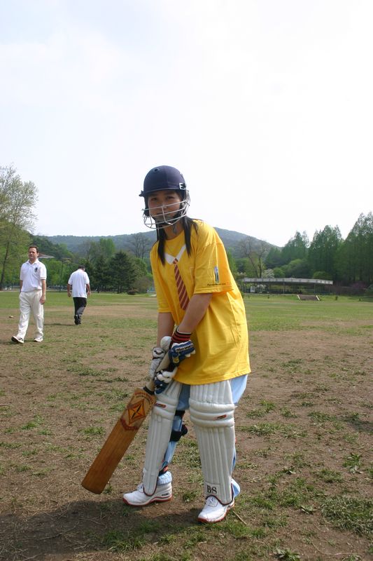
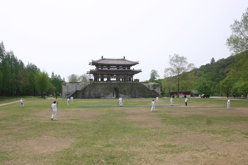
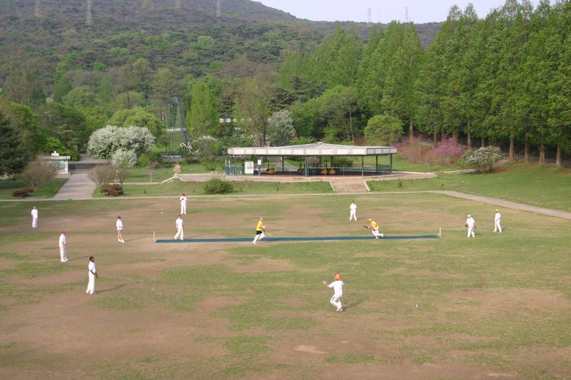
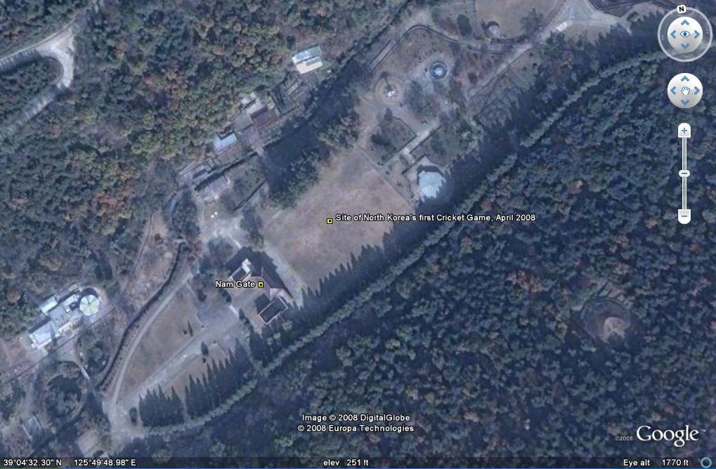
UPDATE: photos from North Korea’s first cricket game:


ORIGINAL POST:
The venue: Mt. Taesong Park.
Click on image for larger view.
This week Pyongyang hosted its first ever cricket match. I hope to get an update on the game when the team returns to China. Until now, here is what we know from the Telegraph:
The three visiting teams for the Twenty20 tournament will be largely expatriates from England, Australia, South Africa and Holland who are based in Shanghai.
The North Korean side will be boosted by staff from the Indian and Pakistani embassies.
The tournament was planned by Bryan Clark, a British employee of the logistics firm DHL, which has an office in Pyongyang, and the Shanghai Cricket Club, which has been leading attempts to develop the game in China.
Read the full story here:
North Koreans take on the English at cricket
Telegraph
Richard Spencer
4/24/2008
Posted in Civil society, Google Earth, Sports | 3 Comments »
Friday, April 25th, 2008
As North Korean Economy Watch readers are aware, this site hosts the most authoritative mapping of North Korea on Google Earth (click here to download). Google Earth recently updated its North Korea imagery requiring me to update a colossal amount of information. This update (version 10) will be released by the end of May.
Growing influence of entrepreneurs
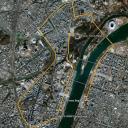
While updating information on Google Earth, one has a chance to compare how things have changed over the course of a few years. One of the interesting changes in Pyongyang is the emergence of a new market about 5 blocks east of the Tower of the Juche Idea (pictured below). It seems to have replaced an older market formerly located on the city’s outskirts at the end of the trolley line. In the past, street markets (or “jangmadang”) like this have been held on the outskirts of the city. This new, more convenient location (near peoples’ homes) is a testament to the growing importance of these markets, and their budding entrepreneurs, in meeting the needs of the North Korean people.

Click on the image to view full size.
Posted in Economic reform, General markets (FMR: Farmers Market), Google Earth, Price liberalization, Private property | 3 Comments »
Thursday, March 13th, 2008
I am saying goodbye to Washington to visit China and Tajikistan. Hoping to catch some Buzkashi and the World Cup qualifier between North and South Korean in Shanghai.
I will return to the US on March 29 and blogging will begin shortly thereafter.
In the meantime, enjoy the latest version of North Korea Uncovered (North Korea Google Earth). The latest version makes a decent contribution to understanding how “marketized” DPRK society has become. Markets (Jangmadang) are everywhere!
Posted in Google Earth | Comments Closed
Thursday, February 14th, 2008
As many readers know, I have been mapping out North Korea’s military facilities (along with many other things) on Google Earth for some time. Having never served in the military, I am not qualified to speculate on what many military locations are, but I discovered a web page that has a phenomenal explication of specific locations, even including 3-D overlay images (two of the may comparisons are at the top of this post).
Anyone who is interested in Google Earth, or North Korea’s military infrastructure, needs to check out the full offerings at “Fortress North Korea” on “militaryphotos.net”.
And if you have not done so, download “North Korea Uncovered v.8” on Google Earth here. Sorry Google Maps users, the file is too large.
Posted in Google Earth, Military | Comments Closed
Friday, February 1st, 2008
 The New York Times (free registration required) ran an article today on Baengnyeong Island, South Korea’s northern most island which is below the NLL (the de jure, though disputed, sea border between the DPRK and the ROK), but only 10 miles from the coast of North Korea.
Fishermen have gone missing from this island for years, and occasionally, naval clashes erupt between the DPRK and ROK. The latter problem, though not the former, was an agenda item on the most recent Inter-Korea talks between Kim Jong Il and the former South Korean President Roh Moo-hyun.
The island is now a sad reminder of the costs of division and isolation:
[F]or Chang Hyung-soo, a 64-year-old retired diver here, this narrow strip of water is what separates him from his hometown [in the PDRK]. It also separates him from three of his friends who were lost in fog while fishing and taken to North Korea three decades ago.
and…
“A few weeks ago, a 93-year-old man came here to take a last look at his hometown across the channel before he died,” Mr. Chang, the retired diver, said from the hilltop. “But he could see nothing because of the fog. I still remember the old man’s tears of disappointment.”
Complicating the matter, however, is the competition from Chinese fishersmen granted territorial access by the DPRK:
To make matters worse, hundreds of Chinese fishing boats, after paying fees to the North Korean Navy, have sailed into waters between their islands and North Korea in recent years while the South Korean fishermen have been restricted to waters close to their own shores.
“The Chinese trawlers catch anything, everything, and deplete our seas,” said Kim Myong-san, 78, who first came to the island as a marine and settled here with his wife.
Notes:
One Eye on the Fish, the Other on North Korea
New York Times
Choe Sang-Hun
1/31/2008
Top image from Google Earth. Download “North Korea Uncovered” to see this location on your own Google Earth.
Posted in Agriculture, China, Google Earth, Military, Sea shipping, Transportation | Comments Closed
Friday, December 14th, 2007
The most authoritative map of North Korea on Google Earth
North Korea Uncovered v.7
Download it here
 This map covers North Korea’s agriculture, aviation, cultural locations, manufacturing facilities, railroad, energy infrastructure, politics, sports venues, military establishments, religious facilities, leisure destinations, and national parks. It is continually expanding and undergoing revisions. This is the sixth version.
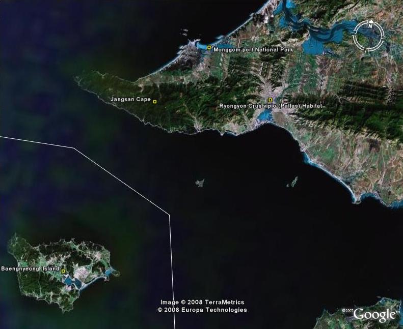
Additions to the latest version of “North Korea Uncovered” include: A Korean War folder featuring overlays of US attacks on the Sui Ho Dam, Yalu Bridge, and Nakwon Munitians Plant (before/after), plus other locations such as the Hoeryong Revolutionary Site, Ponghwa Revolutionary Site, Taechon reactor (overlay), Pyongyang Railway Museum, Kwangmyong Salt Works, Woljong Temple, Sansong Revolutionary Site, Jongbansan Fort and park, Jangsan Cape, Yongbyon House of Culture, Chongsokjong, Lake Yonpung, Nortern Limit Line (NLL), Sinuiju Old Fort Walls, Pyongyang open air market, and confirmed Pyongyang Intranet nodes.
Disclaimer: I cannot vouch for the authenticity of many locations since I have not seen or been to them, but great efforts have been made to check for authenticity. These efforts include pouring over books, maps, conducting interviews, and keeping up with other peoples’ discoveries. In many cases, I have posted sources, though not for all. This is a thorough compilation of lots of material, but I will leave it up to the reader to make up their own minds as to what they see. I cannot catch everything and I welcome contributions.
Posted in Architecture, Art, Automobiles, Aviation, Cell phones, Civil society, Coal, Committee for Cultural Relations with Foreign Countries, Communications, Computing/IT, Construction, Dams/hydro, Department Store No. 1, Education, Electricity, Email, Energy, Film, Finance, Football (soccer), Forestry, Gambling, General markets (FMR: Farmers Market), Golf, Google Earth, Hana Electronics Company, Health care, Hoteling, Hwanggumphyong and Wihwado Economic Zones (Sinuiju), Hyesan Youth Cooper Mine, International Aid, Internet, Intranet, Juche, Kaesong Industrial Complex (KIC), Kim Chaek University of Technology, Kim Il Sung University, Korea Computer Center (KCC), Korean Buddhist Association, Korean People's Army, Light Industry, Lumber, Mansudae creative Company (art studio), Manufacturing, Mass games, Maternity Hospital, Military, Mining/Minerals, Ministry of foreign Affairs, Ministry of Foreign Trade, Mt. Kumgang Tourist Special Zone, Musan Mine, Nuclear, Pyongyang Embroidery Institute, Pyongyang Film Studio, Pyongyang Informatics Center (PIC), Pyongyang International Information Center of New Techn, Pyongyang International Trade Fair, Pyongyang Metro, Pyongyang University of Medicine, Radio, Railways, Rason Economic and Trade Zone (Rajin-Sonbong), Real estate, Religion, Restaurants, Sea shipping, Sports, Television, Transportation, Wind | Comments Closed
