Archive for the ‘Hwanggumphyong and Wihwado Economic Zones (Sinuiju)’ Category
Thursday, June 25th, 2009
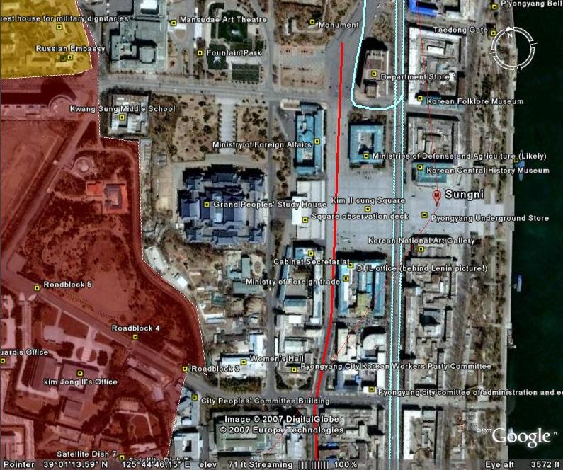
 North Korea Uncovered version 18 is available. This Google Earth overlay maps North Korea’s agriculture, aviation, cultural locations, markets, manufacturing facilities, railroad, energy infrastructure, politics, sports venues, military establishments, religious facilities, leisure destinations, and national parks.
This project has now been downloaded over 140,000 times since launching in April 2007 and received much media attention last month following a Wall Street Journal article highlighting the work.
Note: Kimchaek City is now in high resolution for the first time. Information on this city is pretty scarce. Contributions welcome.
Additions to this version include: New image overlays in Nampo (infrastructure update), Haeju (infrastructure update, apricot trees), Kanggye (infrastructure update, wood processing factory), Kimchaek (infrastructure update). Also, river dredges (h/t Christopher Del Riesgo), the Handure Plain, Musudan update, Nuclear Test Site revamp (h/t Ogle Earth), The International School of Berne (Kim Jong un school), Ongjin Shallow Sea Farms, Monument to “Horizon of the Handure Plain”, Unhung Youth Power Station, Hwangnyong Fortress Wall, Kim Ung so House, Tomb of Kim Ung so, Chungnyol Shrine, Onchon Public Library, Onchon Public bathhouse, Anbyon Youth Power Stations.
Posted in Agriculture, Alcohol, Architecture, Art, Automobiles, Aviation, Banking, Coal, Communications, Construction, Dams/hydro, Education, Electricity, Energy, Environmental protection, Film, Football (soccer), Forestry, Gambling, Gasoline, General markets (FMR: Farmers Market), Golf, Google Earth, Health care, Hoteling, Hwanggumphyong and Wihwado Economic Zones (Sinuiju), Intranet, Kaesong Industrial Complex (KIC), Mass games, Mt. Kumgang Tourist Special Zone, Nuclear, Oil, Pyongyang Metro, Railways, Rason Economic and Trade Zone (Rajin-Sonbong), Religion, Restaurants, Sea shipping, Sports, Tourism, Transportation, Wind | 4 Comments »
Wednesday, March 11th, 2009
North Korea Uncovered v.16
Download it here
The most recent version of North Korea Uncovered (North Korea Google Earth) has been published. Since being launched, this project has been continuously expanded and to date has been downloaded over 32,000 times.
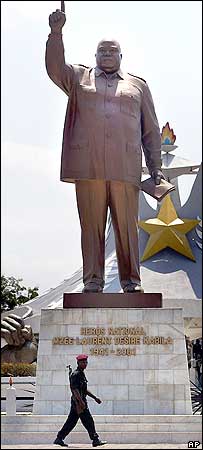
Pictured to the left is a statue of Laurent Kabila of the Democratic Republic of Congo. This statue, as well as many others identified in this version of the project, was built by the North Koreans. According to a visitor:
From the neck down, the Kabila monument looks strangely like Kim Jong Il: baggy uniform, creased pants, the raised arm, a little book in his left hand. From the neck up, the statue is the thick, grim bald mug of Laurent Kabila (his son Joseph is the current president). “The body was made in North Korea,” explains my driver Felix. In other words, the body is Kim Jong Il’s, but with a fat, scowling Kabila head simply welded on.
This is particularly interesting because there are no known pictures of a Kim Jong il statue. The only KJI statue that is reported to exist is in front of the National Security Agency in Pyongyang. If a Kim Jong il statue does in fact exist, it might look something like this.
Thanks again to the anonymous contributors, readers, and fans of this project for your helpful advice and location information. This project would not be successful without your contributions.
Version 16 contains the following additions: Rakwon Machine Complex, Sinuiju Cosmetics Factory, Manpo Restaurant, Worker’s Party No. 3 Building (including Central Committee and Guidance Dept.), Pukchang Aluminum Factory, Pusan-ri Aluminum Factory, Pukchung Machine Complex, Mirim Block Factory, Pyongyang General Textile Factory, Chonnae Cement Factory, Pyongsu Rx Joint Venture, Tongbong Cooperative Farm, Chusang Cooperative Farm, Hoeryong Essential Foodstuff Factory, Kim Ki-song Hoeryong First Middle School , Mirim War University, electricity grid expansion, Tonghae Satellite Launching Ground (TSLG)” is also known as the “Musudan-ri Launching Station,” rebuilt electricity grid, Kumchang-ri suspected underground nuclear site, Wangjaesan Grand Monument, Phothae Revolutionary Site, Naedong Revolutionary Site, Kunja Revolutionary Site, Junggang Revolutionary Site, Phophyong Revolutionary Site, Samdung Revolutionary Site, Phyongsan Granite Mine, Songjin Iron and Steel Complex (Kimchaek), Swedish, German and British embassy building, Taehongdan Potato Processing Factory, Pyongyang Muyseum of Film and Theatrical Arts, Overseas Monuments built by DPRK: Rice Museum (Muzium Padi) in Malaysia, Statue de Patrice Lumumba (Kinshasa, DR Congo), National Heroes Acre (Windhoek, Namibia), Derg Monument (Addis Ababa, Ethiopia), National Heroes Acre (Harare, Zimbabwe), New State House (Windhoek, Namibia), Three Dikgosi (Chiefs) Monument (Gaborone, Botswana), 1st of May Square Statue of Agostinho Neto (Luanda, Angola), Momunment Heroinas Angolas (Luanda, Angola), Monument to the Martyrs of Kifangondo Battle (Luanda, Angola), Place de l’étoile rouge, (Porto Novo, Benin), Statue of King Béhanzin (Abomey, Benin), Monument to the African Renaissance (Dakar, Senegal), Monument to Laurent Kabila [pictured above] (Kinshasa, DR Congo).
Posted in Agriculture, Architecture, Art, Automobiles, Aviation, Banking, Coal, Communications, Computing/IT, Construction, Dams/hydro, Education, Electricity, Energy, Environmental protection, Figure skating, Film, Finance, Fiscal & monetary policy, Food, Football (soccer), Forestry, Gambling, Gasoline, General markets (FMR: Farmers Market), Golf, Google Earth, Health care, Hoteling, Hwanggumphyong and Wihwado Economic Zones (Sinuiju), Intranet, Kaesong Industrial Complex (KIC), Leisure, Library, Light Industry, Mansudae Overseas Development Group, Manufacturing, Mass games, Military, Mining/Minerals, Mt. Kumgang Tourist Special Zone, Music, Nuclear, Oil, Pyongyang Metro, Railways, Rason Economic and Trade Zone (Rajin-Sonbong), Real estate, Religion, Restaurants, Sea shipping, Special Economic Zones (Established before 2013), Sports, Telephones, Television, Tourism, Transportation, Water, Wind | 10 Comments »
Friday, January 23rd, 2009
 On September 20, 2002, the DPRK’s Supreme People’s Assembly announced the creation of the Sinuiju Special Administrative Region (SAR) (KCNA announcement here).
The project was to be headed by a Chinese-born, naturalized Dutch citizen, Yang Bin…who was arrested by Chinese authorities shortly after the Sinuiju SAR was announced. Western analysts interpreted this move as a signal that China was not supportive of either the project or the selection of Mr. Bin as its chief executive. Needless to say the future of the project lay in doubt.
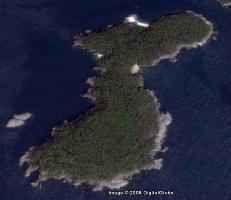
However, according to a Yonhap report (here), as of March 2007 the North Koreans still seemed interested in launching some kind of SAR/SEZ in Sinuiju, though the location had been moved from the city proper to two islands in the Yalu River, Bidan and Wihwa.
In August 2007, IFES and the Choson Ilbo reported that preparations were already underway in Sinuiju to convert the city center into a SAR/SEZ. However, after this initial media hit, most of the news coming out of Sinuiju was related to Jang Song Taek’s 2008 anti-corruption campaign which brought most of the trading companies along the Chinese border back under the control of the Ministry of Finance.
This week, Japan’s Yomuri reports from Shenyang, China, that the Sinuiju SAR is still on and will be located on Wihwa Island:
“The zone will only cover Wi Hwa Island, which will be much easier to control, and only Chinese will be allowed to freely visit,” one of the sources said. “The plan solely aims at expanding trade with China. North Korea isn’t planning any measures that would involve a dramatic opening up.”
According to Chinese statistics, the total value of trade between China and North Korea from January to October last year was 2.12 billion dollars, up 31.7 percent from a year earlier.
Meanwhile, a diplomatic source said, “The move to beef up border trade with China is also aimed at putting pressure on South Korea.”
(FYI: Use of the phrase “beef up” is a pretty good sign that the diplomatic source was an American.)
I know the story of “The Boy Who Cried Wolf.” I will remain skeptical about the new SEZ until I see evidence of construction myself.
You can read the full Yomuri article here:
N. Korea plans free trade zone on island
Daily Yomuri
Toru Makinoda
1/23/2009
Posted in China, Economic reform, Foreign direct investment, Hwanggumphyong and Wihwado Economic Zones (Sinuiju), International trade, Sinuiju Special Administrative Region, Statistics, Trade Statistics | 5 Comments »
Thursday, October 2nd, 2008
North Korea Uncovered: Version 12
Download it here
 About this Project: This map covers North Korea’s agriculture, aviation, cultural locations, markets, manufacturing facilities, energy infrastructure, political facilities, sports venues, military establishments, religious facilities, leisure destinations, national parks, shipping, mining, and railway infrastructure. It is continually expanding and undergoing revisions. This is the 12th version.
Additions include: Tongch’ang-dong launch facility overlay (thanks to Mr. Bermudez), Yongbyon overlay with destroyed cooling tower (thanks to Jung Min Noh), “The Barn” (where the Pueblo crew were kept), Kim Chaek Taehung Fishing Enterprise, Hamhung University of education, Haeju Zoo, Pyongyang: Kim il Sung Institute of Politics, Polish Embassy, Munsu Diplomatic Store, Munsu Gas Station, Munsu Friendship Restaurant, Mongolian Embassy, Nigerian Embassy, UN World Food Program Building, CONCERN House, Czech Republic Embassy, Rungnang Cinema, Pyongyang University of Science and Technology, Pyongyang Number 3 Hospital, Electric Machines Facotry, Bonghuajinlyoso, Second National Academy of Sciences, Central Committee Building, Party Administration Building, Central Statistics Bureau, Willow Capital Food House, Thongounjong Pleasure Ground, Onpho spa, Phipa Resort Hotel, Sunoni Chemical Complex (east coast refinery), Ponghwa Chemical complex (west coast refinery), Songbon Port Revolutionary Monument, Hoeryong People’s Library, Pyongyang Monument to the anti Japanese martyrs, tideland reclamation project on Taegye Island. Additionally the electricity grid was expanded and the thermal power plants have been better organized. Additional thanks to Ryan for his pointers.
I hope this map will increase interest in North Korea. There is still plenty more to learn, and I look forward to receiving your contributions to this project.
Version 12 available: Download it here
Posted in Agriculture, Animation, Architecture, Art, Automobiles, Aviation, Banking, Cell phones, Coal, Communications, Computing/IT, Construction, Copper, Dams/hydro, Education, Electricity, Energy, Environmental protection, Film, Finance, Fiscal & monetary policy, Food, Football (soccer), Foreign direct investment, Forestry, Gambling, Gasoline, General markets (FMR: Farmers Market), Gold, Golf, Google Earth, Health care, Hoteling, Hwanggumphyong and Wihwado Economic Zones (Sinuiju), International trade, Joint Ventures, Kaesong Industrial Complex (KIC), Leisure, Library, Light Industry, Lumber, Manufacturing, Mass games, Military, Mining/Minerals, Mt. Kumgang Tourist Special Zone, Music, Nuclear, Pyongyang Metro, Railways, Rason Economic and Trade Zone (Rajin-Sonbong), Real estate, Religion, Restaurants, Sea shipping, Special Economic Zones (Established before 2013), Sports, Television, Tourism, Transportation, Wind | 1 Comment »
Wednesday, September 3rd, 2008
On this page, I will keep a list of DPRK statutes and summaries:
1. Foreign Investment Law
2. Free Economic and Trade Zone Law
3. Equity Joint Venture Law
4. Contractual Joint Venture Law
5. Foreign Enterprises Law
6. Taxation of Foreign Invested Enterprises
7. Relevant Labor Laws
8. Leasing Land
9. Dispute Resolution
10. Domestic Sales Tax Regulations
11. Manufacturing & Export Operations
12. External Economic Arbitration Law
13. Commercial Joint Venture Law
14. Constitutions (x2)
15. Customs Law
16. Law on Economic Plans
17. Fisheries Law
18. Foreigners in FEZs
19. Intellectual Property
Click “read the rest of this entry” below to see summaries and statute text.
(more…)
Posted in Banking, DPRK Policies, Economic reform, Emigration, Finance, Fiscal & monetary policy, Foreign direct investment, Hwanggumphyong and Wihwado Economic Zones (Sinuiju), Intellectual Property, International trade, Joint Ventures, Labor conditions/wages, Manufacturing, Price liberalization, Private property, Rason Economic and Trade Zone (Rajin-Sonbong), Special Economic Zones (Established before 2013), Statutes | Comments Closed
Thursday, August 14th, 2008
The most authoritative map of North Korea on Google Earth
Download it here
This map covers North Korea’s agriculture, aviation, cultural locations, markets, manufacturing facilities, railroad, energy infrastructure, politics, sports venues, military establishments, religious facilities, leisure destinations, and national parks. It is continually expanding and undergoing revisions. This is the eleventh version.
Additions include: Mt. Paegun’s Ryonghung Temple and resort homes, Pyongyang’s Chongryu Restaurant, Swiss Development Agency (former UNDP office), Iranian Embassy, White Tiger Art Studio, KITC Store, Kumgangsan Store, Pyongyang Fried Chicken Restaurant, Kilju’s Pulp Factory (Paper), Kim Chaek Steel Mill, Chongjin Munitions Factory, Poogin Coal Mine, Ryongwun-ri cooperative farm, Thonggun Pavilion (Uiju), Chinju Temple (Yongbyon), Kim il Sung Revolutionary Museum (Pyongsong), Hamhung Zoo, Rajin electrified perimeter fence, Pyongsong market (North Korea’s largest), Sakju Recreation Center, Hoeryong Maternity Hospital, Sariwon Suwon reservoir (alleged site of US massacre), Sinpyong Resting Place, 700 Ridges Pavilion, Academy of Science, Hamhung Museum of the Revolutionary Activities of Comrade Kim Il Sung, South Hamgyong House of Culture, Hamhung Royal Villa, Pork Chop Hill, and Pyongyang’s Olympic torch route. Additional thanks go to Martyn Williams for expanding the electricity grid, particularly in Samjiyon, and various others who have contributed time improving this project since its launch.
Disclaimer: I cannot vouch for the authenticity of many locations since I have not seen or been to them, but great efforts have been made to check for authenticity. These efforts include pouring over books, maps, conducting interviews, and keeping up with other peoples’ discoveries. In many cases, I have posted sources, though not for all. This is a thorough compilation of lots of material, but I will leave it up to the reader to make up their own minds as to what they see. I cannot catch everything and I welcome contributions. Additionally, this file is getting large and may take some time to load.
Posted in Advertising, Agriculture, Architecture, Art, Automobiles, Aviation, Banking, Biotech, Cell phones, Central Broadcasting Station, Coal, Committee for Cultural Relations with Foreign Countries, Communications, Computing/IT, Construction, Dams/hydro, Demographics, Domestic publication, Education, Electricity, Energy, Environmental protection, Film, Finance, Food, Football (soccer), Foreign direct investment, Forestry, Gambling, Gasoline, General markets (FMR: Farmers Market), Golf, Google Earth, Health care, Hoteling, Hwanggumphyong and Wihwado Economic Zones (Sinuiju), Intranet, Joint Ventures, Kaesong Industrial Complex (KIC), Kim Il Sung University, Korean Buddhist Association, Labor conditions/wages, Leisure, Library, Light Industry, Lumber, Mansu Art Studio, Manufacturing, Mass games, Maternity Hospital, Military, Mining/Minerals, Ministry of foreign Affairs, Ministry of Foreign Trade, Ministry of People’s Armed Forces, Ministry of Post and Telecommunications, Ministry of Public Health, Mt. Kumgang Tourist Special Zone, Musan Mine, Nuclear, Oil, Phoenix Commerical Ventures, Pyongyang Embroidery Institute, Pyongyang Film Studio, Pyongyang International Information Center of New Techn, Pyongyang International Trade Fair, Pyongyang Metro, Pyongyang University of Medicine, Radio, Railways, Rason Economic and Trade Zone (Rajin-Sonbong), Real estate, Religion, Restaurants, Sea shipping, Sports, Steel, Supreme Peoples Assembly, Tourism, Transportation, Wind | 6 Comments »
Friday, December 14th, 2007
The most authoritative map of North Korea on Google Earth
North Korea Uncovered v.7
Download it here
This map covers North Korea’s agriculture, aviation, cultural locations, manufacturing facilities, railroad, energy infrastructure, politics, sports venues, military establishments, religious facilities, leisure destinations, and national parks. It is continually expanding and undergoing revisions. This is the sixth version.
Additions to the latest version of “North Korea Uncovered” include: A Korean War folder featuring overlays of US attacks on the Sui Ho Dam, Yalu Bridge, and Nakwon Munitians Plant (before/after), plus other locations such as the Hoeryong Revolutionary Site, Ponghwa Revolutionary Site, Taechon reactor (overlay), Pyongyang Railway Museum, Kwangmyong Salt Works, Woljong Temple, Sansong Revolutionary Site, Jongbansan Fort and park, Jangsan Cape, Yongbyon House of Culture, Chongsokjong, Lake Yonpung, Nortern Limit Line (NLL), Sinuiju Old Fort Walls, Pyongyang open air market, and confirmed Pyongyang Intranet nodes.
Disclaimer: I cannot vouch for the authenticity of many locations since I have not seen or been to them, but great efforts have been made to check for authenticity. These efforts include pouring over books, maps, conducting interviews, and keeping up with other peoples’ discoveries. In many cases, I have posted sources, though not for all. This is a thorough compilation of lots of material, but I will leave it up to the reader to make up their own minds as to what they see. I cannot catch everything and I welcome contributions.
Posted in Architecture, Art, Automobiles, Aviation, Cell phones, Civil society, Coal, Committee for Cultural Relations with Foreign Countries, Communications, Computing/IT, Construction, Dams/hydro, Department Store No. 1, Education, Electricity, Email, Energy, Film, Finance, Football (soccer), Forestry, Gambling, General markets (FMR: Farmers Market), Golf, Google Earth, Hana Electronics Company, Health care, Hoteling, Hwanggumphyong and Wihwado Economic Zones (Sinuiju), Hyesan Youth Cooper Mine, International Aid, Internet, Intranet, Juche, Kaesong Industrial Complex (KIC), Kim Chaek University of Technology, Kim Il Sung University, Korea Computer Center (KCC), Korean Buddhist Association, Korean People's Army, Light Industry, Lumber, Mansudae creative Company (art studio), Manufacturing, Mass games, Maternity Hospital, Military, Mining/Minerals, Ministry of foreign Affairs, Ministry of Foreign Trade, Mt. Kumgang Tourist Special Zone, Musan Mine, Nuclear, Pyongyang Embroidery Institute, Pyongyang Film Studio, Pyongyang Informatics Center (PIC), Pyongyang International Information Center of New Techn, Pyongyang International Trade Fair, Pyongyang Metro, Pyongyang University of Medicine, Radio, Railways, Rason Economic and Trade Zone (Rajin-Sonbong), Real estate, Religion, Restaurants, Sea shipping, Sports, Television, Transportation, Wind | Comments Closed
Sunday, November 11th, 2007
The most authoritative map of North Korea on Google Earth
North Korea Uncovered: Version 6
Download it here
 This map covers North Korea’s agriculture, aviation, cultural locations, manufacturing facilities, railroad, energy infrastructure, politics, sports venues, military establishments, religious facilities, leisure destinations, and national parks. It is continually expanding and undergoing revisions. This is the sixth version.
Additions to the newest version of North Korea Uncovered include: Alleged Syrian nuclear site (before and after bombing), Majon beach resort, electricity grid expansion, Runga Island in Pyongyang, Mt. Ryongak, Yongbyon historical fort walls, Suyang Fort walls and waterfall in Haeju, Kaechon-Lake Taesong water project, Paekma-Cholsan waterway, Yachts (3), and Hyesan Youth Copper Mine.
Disclaimer: I cannot vouch for the authenticity of many locations since I have not seen or been to them, but great efforts have been made to check for authenticity. These efforts include pouring over books, maps, conducting interviews, and keeping up with other peoples’ discoveries. In many cases, I have posted sources, though not for all. This is a thorough compilation of lots of material, but I will leave it up to the reader to make up their own minds as to what they see. I cannot catch everything and I welcome contributions.
Posted in Advertising, Agriculture, Architecture, Automobiles, Aviation, Banking, Black markets, Committee for Cultural Relations with Foreign Countries, Communications, Computing/IT, Dams/hydro, Department Store No. 1, Economic reform, Education, Electricity, Energy, Environmental protection, Film, Finance, Fiscal & monetary policy, Football (soccer), Forestry, Gambling, Gasoline, General markets (FMR: Farmers Market), Golf, Google Earth, Hana Electronics Company, Health care, Hoteling, Hwanggumphyong and Wihwado Economic Zones (Sinuiju), Hyesan Youth Cooper Mine, Kaesong Industrial Complex (KIC), Kim Il Sung University, Korea Computer Center (KCC), Library, Light Industry, Mansudae creative Company (art studio), Manufacturing, Mass games, Maternity Hospital, Military, Mining/Minerals, Ministry of Culture, Ministry of Foreign Trade, Mt. Kumgang Tourist Special Zone, Musan Mine, Music, Nuclear, Pyongyang Embroidery Institute, Pyongyang Film Studio, Pyongyang Informatics Center (PIC), Pyongyang International Information Center of New Techn, Pyongyang International Trade Fair, Pyongyang Metro, Railways, Rason Economic and Trade Zone (Rajin-Sonbong), Real estate, Religion, Restaurants, Sea shipping, Special Economic Zones (Established before 2013), Sports, Steel, Supreme Peoples Assembly, Television, Tourism, Transportation, Water, Wind | Comments Closed
Saturday, October 6th, 2007
Version 5: Download it here (on Google Earth)
This map covers North Korea’s agriculture, aviation, cultural locations, manufacturing facilities, railroad, energy infrastructure, politics, sports venues, military establishments, religious facilities, leisure destinations, and national parks. It is continually expanding and undergoing revisions. This is the fifth version.
Additions to the latest version of “North Korea Uncovered” include updates to new Google Earth overlays of Sinchon, UNESCO sites, Railroads, canals, and the DMZ, in addition to Kim Jong Suk college of eduation (Hyesan), a huge expansion of the electricity grid (with a little help from Martyn Williams) plus a few more parks, antiaircraft sites, dams, mines, canals, etc.
Disclaimer: I cannot vouch for the authenticity of many locations since I have not seen or been to them, but great efforts have been made to check for authenticity. These efforts include pouring over books, maps, conducting interviews, and keeping up with other peoples’ discoveries. In many cases, I have posted sources, though not for all. This is a thorough compilation of lots of material, but I will leave it up to the reader to make up their own minds as to what they see. I cannot catch everything and I welcome contributions.
I hope this map will increase interest in North Korea. There is still plenty more to learn, and I look forward to receiving your additions to this project.
Posted in 1990s Famine, Advertising, Agriculture, Architecture, Arduous March, Art, Automobiles, Aviation, Banking, Civil society, Coal, Communications, Computing/IT, Cosmetics, Dams/hydro, DPRK organizations, Economic reform, Education, Electricity, Energy, Environmental protection, Film, Finance, Fiscal & monetary policy, Football (soccer), Foreign direct investment, Forestry, Gambling, Gasoline, General markets (FMR: Farmers Market), Golf, Google Earth, Health care, Hoteling, Hwanggumphyong and Wihwado Economic Zones (Sinuiju), Illicit activities, Juche, Kaesong Industrial Complex (KIC), Labor conditions/wages, Leisure, Library, Light Industry, Manufacturing, Mass games, Military, Mining/Minerals, Mt. Kumgang Tourist Special Zone, Music, Nuclear, Political economy, Pyongyang International Trade Fair, Pyongyang Metro, Radio, Railways, Rason Economic and Trade Zone (Rajin-Sonbong), Real estate, Religion, Restaurants, Sea shipping, Special Economic Zones (Established before 2013), Television, Tourism, Transportation, Water, Worker's Party | 2 Comments »
Wednesday, August 29th, 2007
The most authoritative, publicly available map of North Korea
Version 4: August 29, 2007
Download it here
This map covers North Korea’s agriculture, aviation, cultural locations, manufacturing facilities, railroad, energy infrastructure, politics, sports venues, military establishments, religious facilities, leisure destinations, and national parks. It is continually expanding and undergoing revisions. This is the fourth version.
Additions to the latest version of “North Korea Uncovered” include the city of Manpo along the Chinese border, KEDO, Kumgang Resort expansion, Kaesong Industrial Zone, as well as a few more parks, antiaircraft sites, dams, mines, canals, etc. I have also added more links in the menu which will tell the viewer a bit about the locations themselves. I have also changed the color scheme to make the collage easier to view.
Disclaimer: I cannot vouch for the authenticity of many locations since I have not seen or been to them, but great efforts have been made to check for authenticity. These efforts include pouring over books, maps, conducting interviews, and keeping up with other peoples’ discoveries. In many cases, I have posted sources, though not for all. This is a thorough compilation of lots of material, but I will leave it up to the reader to make up their own minds as to what they see. I cannot catch everything and I welcome contributions.
I hope this map will increase interest in North Korea. There is still plenty more to learn, and I look forward to receiving your additions to this project.
Posted in Agriculture, Architecture, Automobiles, Aviation, Biotech, Dams/hydro, Education, Electricity, Energy, Environmental protection, Fiscal & monetary policy, Forestry, Gasoline, General markets (FMR: Farmers Market), Google Earth, Health care, Hoteling, Hwanggumphyong and Wihwado Economic Zones (Sinuiju), International trade, Kaesong Industrial Complex (KIC), Labor conditions/wages, Leisure, Library, Light Industry, Lumber, Manufacturing, Military, Mining/Minerals, Mt. Kumgang Tourist Special Zone, Political economy, Pyongyang International Trade Fair, Pyongyang Metro, Railways, Rason Economic and Trade Zone (Rajin-Sonbong), Real estate, Sea shipping, Special Economic Zones (Established before 2013), Tourism, Transportation, Water, Wind | 1 Comment »
