Archive for the ‘Google Earth’ Category
Sunday, March 29th, 2009
 Though this web page is not focused on military affairs, today the Institute for Science and International Security (ISIS) sent out a picture of North Korea’s Taepodong 2 missile sitting on the launch pad at Musudan-ri. According to their email:
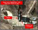
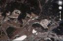
ISIS has obtained commercial satellite imagery from DigitalGlobe taken at approximately 11:00 AM local time on March 29, 2009 of the Musudan-ri missile site in North Korea. The missile is clearly visible in this image. It is also casting a shadow that is clearly differentiated from the missile launch gantry. According to news reports, the missile was installed on or after Tuesday, March 24, 2009. Since the missile is so easily seen in this image versus in imagery over the past several days since March 24 , it is likely that North Korea was previously shrouding the missile.
You may see the ISIS report here.
You can see the launch trajectory mapped out on Google Earth here.
As the T-2 will not threaten US territory, Uncle Sam has no plans to interfere with the launch.
Posted in Google Earth, Military | 2 Comments »
Wednesday, March 11th, 2009
North Korea Uncovered v.16
Download it here
The most recent version of North Korea Uncovered (North Korea Google Earth) has been published. Since being launched, this project has been continuously expanded and to date has been downloaded over 32,000 times.
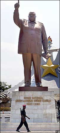
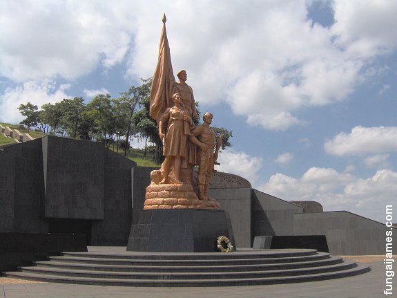
Pictured to the left is a statue of Laurent Kabila of the Democratic Republic of Congo. This statue, as well as many others identified in this version of the project, was built by the North Koreans. According to a visitor:
From the neck down, the Kabila monument looks strangely like Kim Jong Il: baggy uniform, creased pants, the raised arm, a little book in his left hand. From the neck up, the statue is the thick, grim bald mug of Laurent Kabila (his son Joseph is the current president). “The body was made in North Korea,” explains my driver Felix. In other words, the body is Kim Jong Il’s, but with a fat, scowling Kabila head simply welded on.
This is particularly interesting because there are no known pictures of a Kim Jong il statue. The only KJI statue that is reported to exist is in front of the National Security Agency in Pyongyang. If a Kim Jong il statue does in fact exist, it might look something like this.
Thanks again to the anonymous contributors, readers, and fans of this project for your helpful advice and location information. This project would not be successful without your contributions.
Version 16 contains the following additions: Rakwon Machine Complex, Sinuiju Cosmetics Factory, Manpo Restaurant, Worker’s Party No. 3 Building (including Central Committee and Guidance Dept.), Pukchang Aluminum Factory, Pusan-ri Aluminum Factory, Pukchung Machine Complex, Mirim Block Factory, Pyongyang General Textile Factory, Chonnae Cement Factory, Pyongsu Rx Joint Venture, Tongbong Cooperative Farm, Chusang Cooperative Farm, Hoeryong Essential Foodstuff Factory, Kim Ki-song Hoeryong First Middle School , Mirim War University, electricity grid expansion, Tonghae Satellite Launching Ground (TSLG)” is also known as the “Musudan-ri Launching Station,” rebuilt electricity grid, Kumchang-ri suspected underground nuclear site, Wangjaesan Grand Monument, Phothae Revolutionary Site, Naedong Revolutionary Site, Kunja Revolutionary Site, Junggang Revolutionary Site, Phophyong Revolutionary Site, Samdung Revolutionary Site, Phyongsan Granite Mine, Songjin Iron and Steel Complex (Kimchaek), Swedish, German and British embassy building, Taehongdan Potato Processing Factory, Pyongyang Muyseum of Film and Theatrical Arts, Overseas Monuments built by DPRK: Rice Museum (Muzium Padi) in Malaysia, Statue de Patrice Lumumba (Kinshasa, DR Congo), National Heroes Acre (Windhoek, Namibia), Derg Monument (Addis Ababa, Ethiopia), National Heroes Acre (Harare, Zimbabwe), New State House (Windhoek, Namibia), Three Dikgosi (Chiefs) Monument (Gaborone, Botswana), 1st of May Square Statue of Agostinho Neto (Luanda, Angola), Momunment Heroinas Angolas (Luanda, Angola), Monument to the Martyrs of Kifangondo Battle (Luanda, Angola), Place de l’étoile rouge, (Porto Novo, Benin), Statue of King Béhanzin (Abomey, Benin), Monument to the African Renaissance (Dakar, Senegal), Monument to Laurent Kabila [pictured above] (Kinshasa, DR Congo).
Posted in Agriculture, Architecture, Art, Automobiles, Aviation, Banking, Coal, Communications, Computing/IT, Construction, Dams/hydro, Education, Electricity, Energy, Environmental protection, Figure skating, Film, Finance, Fiscal & monetary policy, Food, Football (soccer), Forestry, Gambling, Gasoline, General markets (FMR: Farmers Market), Golf, Google Earth, Health care, Hoteling, Hwanggumphyong and Wihwado Economic Zones (Sinuiju), Intranet, Kaesong Industrial Complex (KIC), Leisure, Library, Light Industry, Mansudae Overseas Development Group, Manufacturing, Mass games, Military, Mining/Minerals, Mt. Kumgang Tourist Special Zone, Music, Nuclear, Oil, Pyongyang Metro, Railways, Rason Economic and Trade Zone (Rajin-Sonbong), Real estate, Religion, Restaurants, Sea shipping, Special Economic Zones (Established before 2013), Sports, Telephones, Television, Tourism, Transportation, Water, Wind | 10 Comments »
Friday, March 6th, 2009
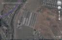
 As regular Google Earth users are aware, the DPRK has experienced significant deforestation in recent decades from both private and state actors. The former have cleared land for fuel/heat and private food production. The latter have felled forests to export lumber. However, without private property rights over the lumber and corollary price signals, we have witnessed yet another “tragedy of the commons”–the over extraction of a common-pool resource.
As can be seen in the image above, official reforestation campaigns have been launched several times. According to Good Friends, the most recent was announced last September, shortly before the DPRK appointed a new forestry minister, Kim Kwang-yong. According to the Yonhap article below, however, South Koreans and Europeans have been supporting reforestation projects in the DPRK for nearly ten years:
North Korean workers and students rolled up their sleeves Monday for Tree-planting Day, state-run media said, amid continuing aid from South Korea despite damaged political relations.
North Korea has a high deforestation rate, as residents have cut down trees for fuel. Deforestation is closely linked to the country’s chronic food shortages, as barren mountain slopes leave rice farms prone to severe flooding by summer monsoons, according to aid workers in Seoul.
The North Korean government has banned cutting trees and sought to make its country greener with aid from South Korea and some European governments.
“Covered with trees are mountains and fields of the country from the foot of Mount Paektu, the sacred mountain of the revolution, to the military demarcation line and from the eastern coast to the western coast,” the Korean Central News Agency said in an English-language report titled “Greening and Gardening Campaign Gets Brisk.”
“The tree-planting campaign is being briskly undertaken everywhere in the country … changing the appearance of the country beyond recognition day by day,” it said.
South Korean government and civic groups have been operating sapling fields in the North Korean cities of Kaesong and Pyongyang, as well as near the North’s scenic resort Mount Kumgang, providing seedlings, equipment and technology since 1999. The project has cost South Korea some 9 billion won (US$5.7 million), according to the Ministry of Unification.
Aid workers said the inter-Korean forestry project has continued even though Pyongyang cut off all government-level dialogue in response to Seoul’s hardline policy toward it that began last year.
Ahn Sun-kyong, an aid worker from Green One Korea, an umbrella group of over a dozen non-governmental organizations in Seoul, said it plans to build a seed preservation facility and an apple farm in Pyongyang as new projects this year.
“There may be certain limitations, but this non-governmental exchange project will continue,” Ahn said.
Hwang Jae-sung from the Korean Sharing Movement, which operates the Kaepung sapling field in Kaesong as a member of Green One Korea, said most trees are prematurely cut by residents, who also rake up fallen leaves for fuel.
“Deforestation is directly linked to the food problem,” Hwang, who last visited Kaesong in November, said. “We believe tree planting in North Korea is not only useful for preventing floods, but also can be another means of resolving the food shortages in the North.”
The aid groups say 16-18 percent of North Korean forests, or 1.5-1.6 million hectares out of the North’s 8.9 million hectares of forests, are believed to be deforested. About 80 percent of North Korea is covered by mountains.
Although the support offered by these groups is necessary to restore ecological health and productive power of the DPRK’s agricultural lands, an unfortunate consequence will likely be growing restrictions on private food production which will necessarily require the North Korean people to once again rely on the state for food distribution.
Read previous posts on forestry and environmental protection here.
Read the Yonhap story here:
N. Koreans work to make country green on Tree-planting Day: report
Yonhap
Kim Hyun
3/2/2009
Posted in Environmental protection, EU, Food, Foreign aid statistics, Forestry, Google Earth, Green One Korea, Korean Sharing Movement, Lumber, Ministry of Forestry, South Korea, Statistics | 3 Comments »
Friday, February 27th, 2009
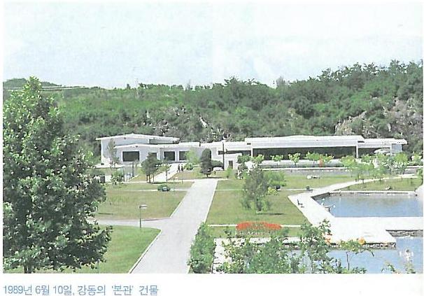
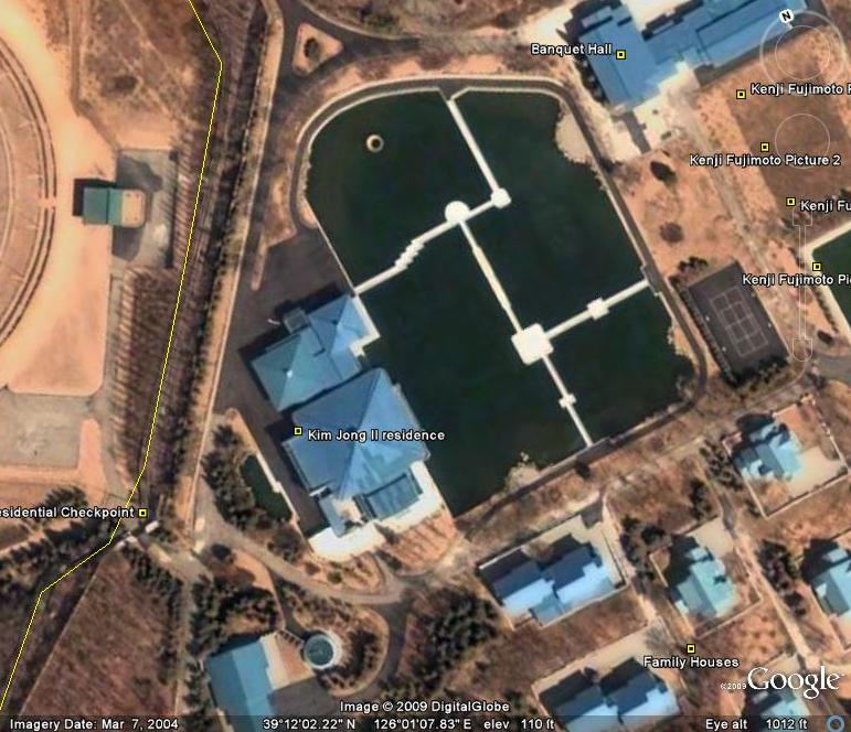
In the last twenty years, a number of 1960s-era, Soviet-style houses in the DPRK’s elite housing compounds have been upgraded into more “western-contemporary” housing. For example, compare Kenji Fujimoto’s 1989 Kangdong photo (below) with a 2004 image from Google Earth:
1989
|

2004
|
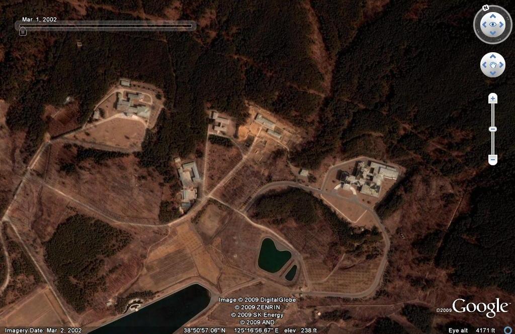
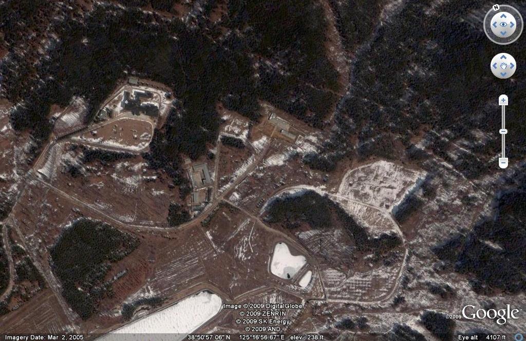
Judging from Google Earth imagery, this process is largely completed, though there still appear to be a few locations that that have not been remodeled. Looking at Onchon County (below) we can see that the reconstruction of old-style compounds was still under way as of 2005. The house on the left of both photos appears to already be upgraded in 2002, but by 2005 the unit on the right of the first photo (below) has been completely leveled. Reconstruction of this residence was probably underway into early 2006.
|

3/1/2002
|
3/2/2005
|
I do not know the calculus used to determine which residencies are updated, neither in degree nor order. I am also immediately unaware of which organization/s is/are responsible for construction/maintenance of these facilities. A KPA unit built Sihanouk’s palace on Lake Changsuwon, and it is reasonable to believe the same unit constructed in the above locations as well. If any readers have more information on this, please let me know.
UPDATE: (Hat tip to Mike) “The residences are either constructed on commission or they are presented to KJI, or some other CCKWP cadre, as a gift. KJI, his family, members of the Kang and Jang families, long time CCKWP members and select intelligence/security appartus officials are known to have designated homes.
The home are constructed by KPA construction units (like Changsuwon) in cooperation with civilian crews under the auspices of the Escort/Bodyguard Bureau. Some members of the civilian crews also work on the large monuments in the DPRK, and overseas. When the homes are built or renovated on commission, the financing comes from the CCKWP offices. A lot of the fixtures and furnishings are purchased through SOE’s or by discreet MOFA officers. A lot of these purchases are conducted in Beijing, Moscow, Geneva, Vienna and Paris. “
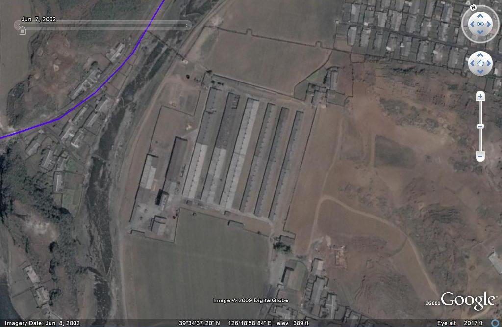
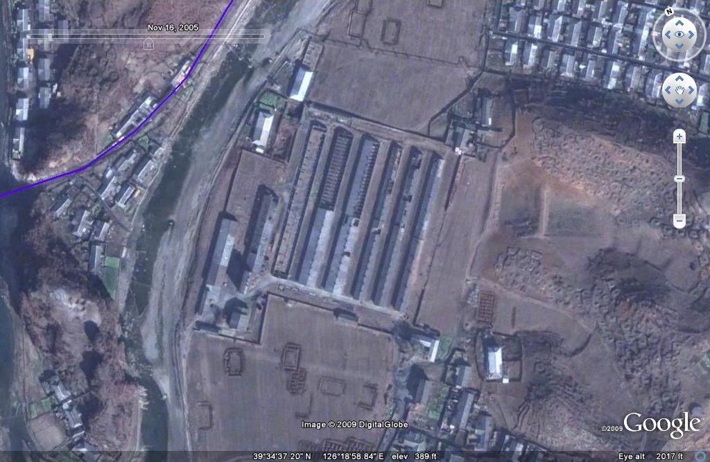
Not to draw to stark a comparison, but the reverse process is also evident through dated satellite photos. This warehouse/factory near the Bukchang Thermal Power Plant has clearly fallen into disrepair (and possible asset stripping) between 2002 and 2005.
|
7/7/2002
|
11/16/2005
|
Posted in Construction, Google Earth, Real estate | 2 Comments »
Monday, February 23rd, 2009
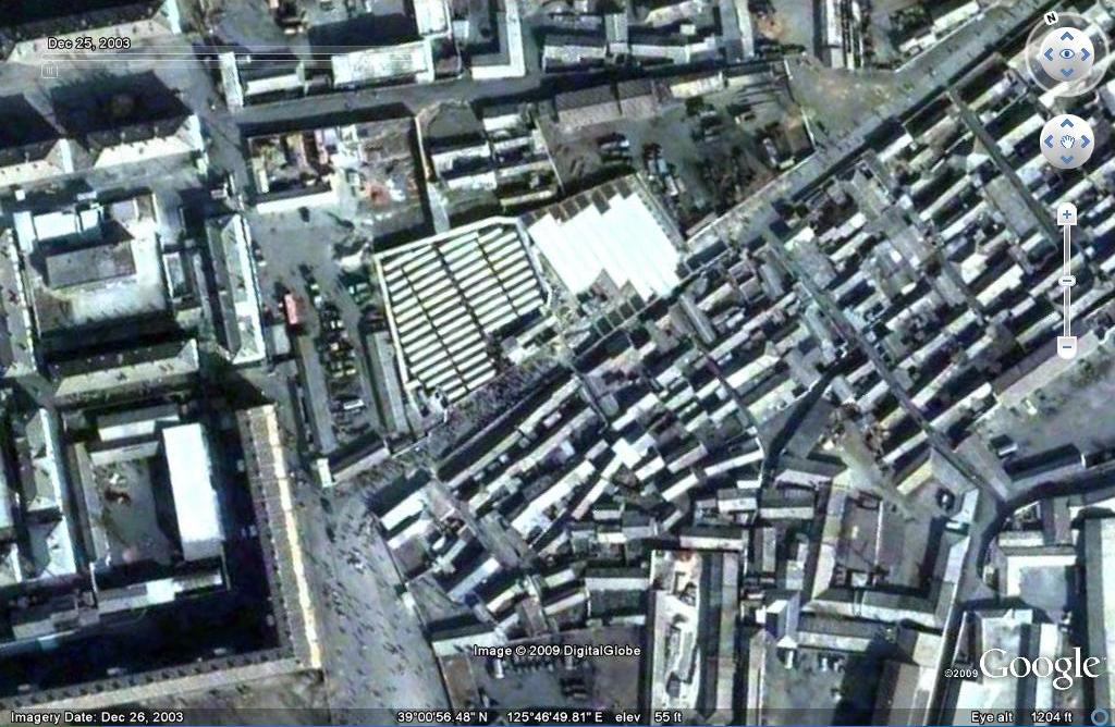
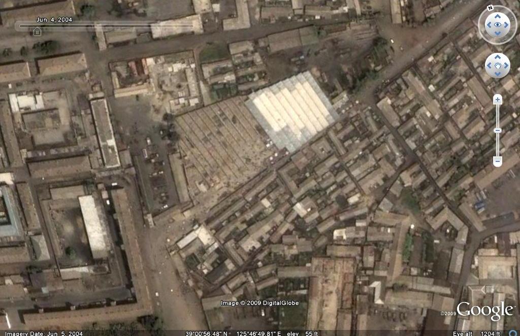
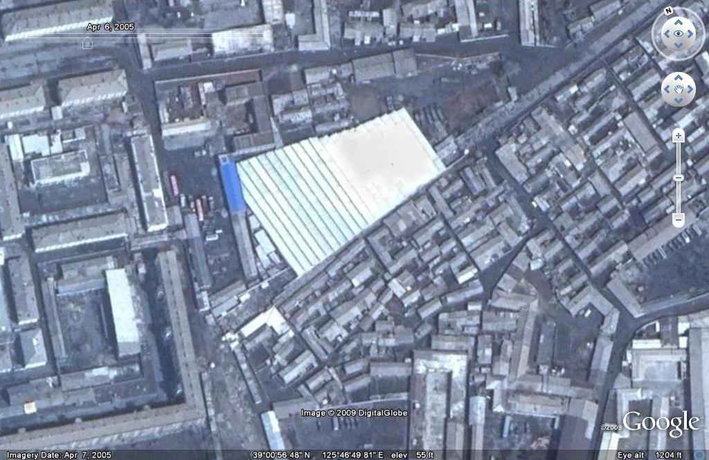
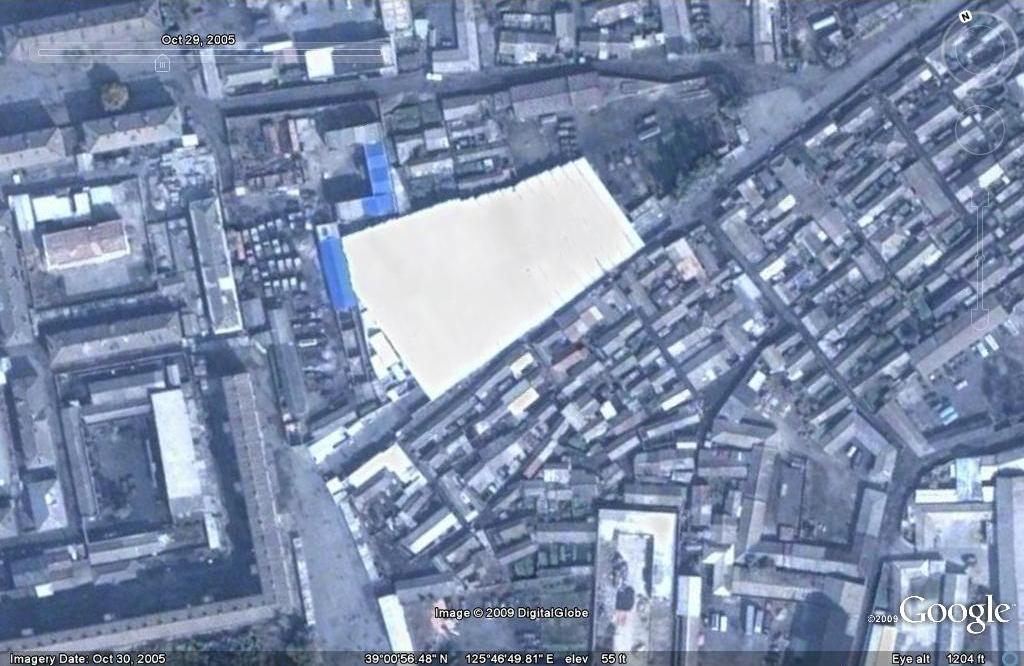
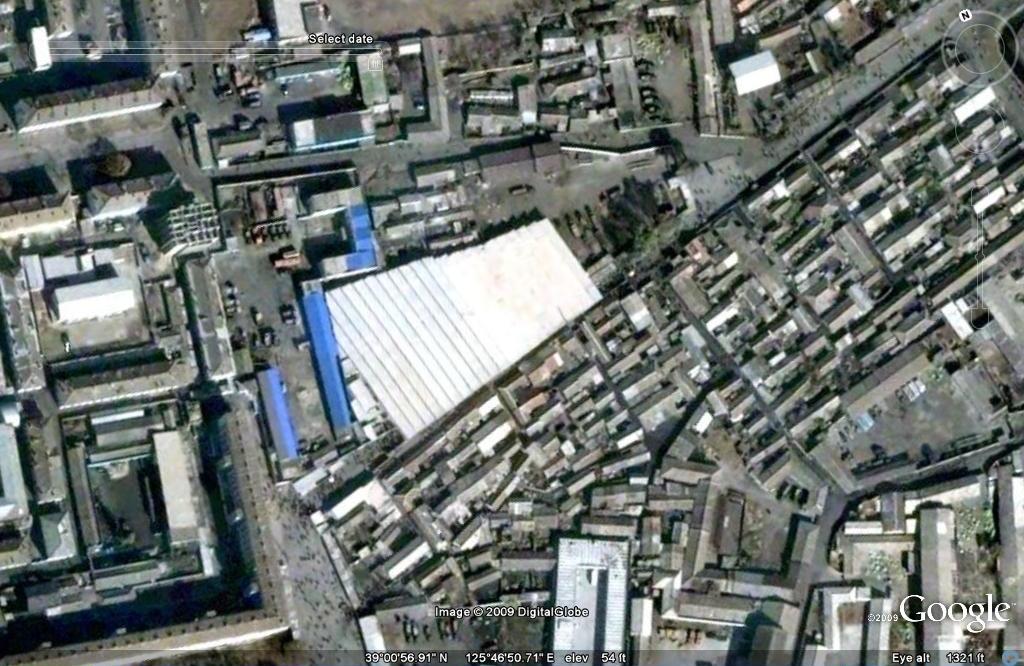
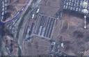
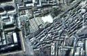
The newest version of Google Earth allows the user to scroll backwards in time to see how a specific area has changed over the years. Although the satelite imagery available for North Korea needs to be expanded, by utilizing the current stock of photos we can uncover some interesting developments.
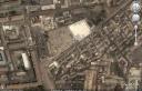
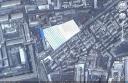
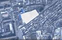
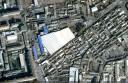
Below is an example—a bird’s eye view of the expansion of Pyongyang’s eastern market (click on images for full size):
December 25, 2003
June 4, 2004
April 6, 2005
October 29, 2005
Most recently
If any readers out there discover other interesting developments please let me know.
Posted in Construction, General markets (FMR: Farmers Market), Google Earth, Real estate | Comments Closed
Tuesday, February 3rd, 2009
National Heroes Acre is a burial ground in Harare, Zimbabwe for all Zimbabweans who have been declared a hero by the Government.
The Government started work on the Heroes Acre in 1981, one year after Independence. The design and artwork used at the site was done by seven artists from the Democratic Peoples Republic of Korea and ten Zimbabwean Artists.
Over 250 local workers were involved in the project at the height of construction. The black granite stone used for the main construction was quarried from Mutoko; a rural area situated about 140km Northeast of Harare. The Heroes Acre is protected under the Natural Resources Act.
See the Site on Wikimapia here.
Learn more about the site here.
*This location will be added to the next version of North Korea Uncovered (North Korea Google Earth). If readers are aware of other construction projects the DPRK has supported, please let me know. I am especially interested in locating the North Korean restaurants in China, Thailand, Cambodia, Vietnam, and Bangladesh. Are there others?
Posted in Architecture, Construction, Google Earth, Zimbabwe | 4 Comments »
Sunday, October 19th, 2008
Google Earth added some image overlays to the DPRK and shifted some older images, so out of the kindness of my heart I reorganized the place marks to give you a more authoritative geographical experience!
I also added a couple of new locations: Cholima Steel Works, Jang Chol Gu University of Commerce, the DPRK’s Central Bank, Changwang Kindergarden, Chongryun Housing, and Maekjon Ferry Relics. Addtionally the electricity grid and railway network have been marginally imporved. Thanks to “HandyDandy61”.
You can download the most recent version of North Korea Uncovered here.
Posted in Google Earth | Comments Closed
Thursday, October 2nd, 2008
North Korea Uncovered: Version 12
Download it here
 About this Project: This map covers North Korea’s agriculture, aviation, cultural locations, markets, manufacturing facilities, energy infrastructure, political facilities, sports venues, military establishments, religious facilities, leisure destinations, national parks, shipping, mining, and railway infrastructure. It is continually expanding and undergoing revisions. This is the 12th version.
Additions include: Tongch’ang-dong launch facility overlay (thanks to Mr. Bermudez), Yongbyon overlay with destroyed cooling tower (thanks to Jung Min Noh), “The Barn” (where the Pueblo crew were kept), Kim Chaek Taehung Fishing Enterprise, Hamhung University of education, Haeju Zoo, Pyongyang: Kim il Sung Institute of Politics, Polish Embassy, Munsu Diplomatic Store, Munsu Gas Station, Munsu Friendship Restaurant, Mongolian Embassy, Nigerian Embassy, UN World Food Program Building, CONCERN House, Czech Republic Embassy, Rungnang Cinema, Pyongyang University of Science and Technology, Pyongyang Number 3 Hospital, Electric Machines Facotry, Bonghuajinlyoso, Second National Academy of Sciences, Central Committee Building, Party Administration Building, Central Statistics Bureau, Willow Capital Food House, Thongounjong Pleasure Ground, Onpho spa, Phipa Resort Hotel, Sunoni Chemical Complex (east coast refinery), Ponghwa Chemical complex (west coast refinery), Songbon Port Revolutionary Monument, Hoeryong People’s Library, Pyongyang Monument to the anti Japanese martyrs, tideland reclamation project on Taegye Island. Additionally the electricity grid was expanded and the thermal power plants have been better organized. Additional thanks to Ryan for his pointers.
I hope this map will increase interest in North Korea. There is still plenty more to learn, and I look forward to receiving your contributions to this project.
Version 12 available: Download it here
Posted in Agriculture, Animation, Architecture, Art, Automobiles, Aviation, Banking, Cell phones, Coal, Communications, Computing/IT, Construction, Copper, Dams/hydro, Education, Electricity, Energy, Environmental protection, Film, Finance, Fiscal & monetary policy, Food, Football (soccer), Foreign direct investment, Forestry, Gambling, Gasoline, General markets (FMR: Farmers Market), Gold, Golf, Google Earth, Health care, Hoteling, Hwanggumphyong and Wihwado Economic Zones (Sinuiju), International trade, Joint Ventures, Kaesong Industrial Complex (KIC), Leisure, Library, Light Industry, Lumber, Manufacturing, Mass games, Military, Mining/Minerals, Mt. Kumgang Tourist Special Zone, Music, Nuclear, Pyongyang Metro, Railways, Rason Economic and Trade Zone (Rajin-Sonbong), Real estate, Religion, Restaurants, Sea shipping, Special Economic Zones (Established before 2013), Sports, Television, Tourism, Transportation, Wind | 1 Comment »
Thursday, August 14th, 2008
The most authoritative map of North Korea on Google Earth
Download it here
 This map covers North Korea’s agriculture, aviation, cultural locations, markets, manufacturing facilities, railroad, energy infrastructure, politics, sports venues, military establishments, religious facilities, leisure destinations, and national parks. It is continually expanding and undergoing revisions. This is the eleventh version.
Additions include: Mt. Paegun’s Ryonghung Temple and resort homes, Pyongyang’s Chongryu Restaurant, Swiss Development Agency (former UNDP office), Iranian Embassy, White Tiger Art Studio, KITC Store, Kumgangsan Store, Pyongyang Fried Chicken Restaurant, Kilju’s Pulp Factory (Paper), Kim Chaek Steel Mill, Chongjin Munitions Factory, Poogin Coal Mine, Ryongwun-ri cooperative farm, Thonggun Pavilion (Uiju), Chinju Temple (Yongbyon), Kim il Sung Revolutionary Museum (Pyongsong), Hamhung Zoo, Rajin electrified perimeter fence, Pyongsong market (North Korea’s largest), Sakju Recreation Center, Hoeryong Maternity Hospital, Sariwon Suwon reservoir (alleged site of US massacre), Sinpyong Resting Place, 700 Ridges Pavilion, Academy of Science, Hamhung Museum of the Revolutionary Activities of Comrade Kim Il Sung, South Hamgyong House of Culture, Hamhung Royal Villa, Pork Chop Hill, and Pyongyang’s Olympic torch route. Additional thanks go to Martyn Williams for expanding the electricity grid, particularly in Samjiyon, and various others who have contributed time improving this project since its launch.
Disclaimer: I cannot vouch for the authenticity of many locations since I have not seen or been to them, but great efforts have been made to check for authenticity. These efforts include pouring over books, maps, conducting interviews, and keeping up with other peoples’ discoveries. In many cases, I have posted sources, though not for all. This is a thorough compilation of lots of material, but I will leave it up to the reader to make up their own minds as to what they see. I cannot catch everything and I welcome contributions. Additionally, this file is getting large and may take some time to load.
Posted in Advertising, Agriculture, Architecture, Art, Automobiles, Aviation, Banking, Biotech, Cell phones, Central Broadcasting Station, Coal, Committee for Cultural Relations with Foreign Countries, Communications, Computing/IT, Construction, Dams/hydro, Demographics, Domestic publication, Education, Electricity, Energy, Environmental protection, Film, Finance, Food, Football (soccer), Foreign direct investment, Forestry, Gambling, Gasoline, General markets (FMR: Farmers Market), Golf, Google Earth, Health care, Hoteling, Hwanggumphyong and Wihwado Economic Zones (Sinuiju), Intranet, Joint Ventures, Kaesong Industrial Complex (KIC), Kim Il Sung University, Korean Buddhist Association, Labor conditions/wages, Leisure, Library, Light Industry, Lumber, Mansu Art Studio, Manufacturing, Mass games, Maternity Hospital, Military, Mining/Minerals, Ministry of foreign Affairs, Ministry of Foreign Trade, Ministry of People’s Armed Forces, Ministry of Post and Telecommunications, Ministry of Public Health, Mt. Kumgang Tourist Special Zone, Musan Mine, Nuclear, Oil, Phoenix Commerical Ventures, Pyongyang Embroidery Institute, Pyongyang Film Studio, Pyongyang International Information Center of New Techn, Pyongyang International Trade Fair, Pyongyang Metro, Pyongyang University of Medicine, Radio, Railways, Rason Economic and Trade Zone (Rajin-Sonbong), Real estate, Religion, Restaurants, Sea shipping, Sports, Steel, Supreme Peoples Assembly, Tourism, Transportation, Wind | 6 Comments »
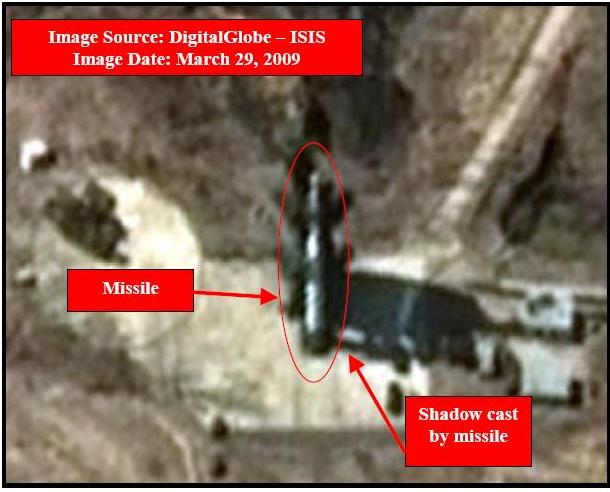 Though this web page is not focused on military affairs, today the Institute for Science and International Security (ISIS) sent out a picture of North Korea’s Taepodong 2 missile sitting on the launch pad at Musudan-ri. According to their email: