Archive for the ‘Wind’ Category
Tuesday, January 13th, 2009
NCNK Newsletter Vol. 2, Issue 1
January 13, 2009
Download PDF here
A DPRK “Shangri-la” Powered by Solar Electricity
By Victor Hsu
In 1988 Bongsu Church — the first Protestant Church built in Pyongyang since the end of the Korean War — opened its doors for the first time. The following year the Korean Christians Federation asked if my organization, Church World Service, would provide a generator for the brand new church. A generator would enable parishioners to enjoy air conditioning during the hot summer months when the temperature can reach 85 degrees Fahrenheit and above. I suggested to the church officials that we install solar generators from China. However, lacking experience with solar power, they preferred the more familiar diesel-powered generators. But the seeds of interest in alternative sources of energy were just starting to grow. Soon after this exchange I learned that the DPRK was investigating the possibility of using another form of renewable energy — windmills.
I have been visiting the DPRK for two decades in many different capacities, most recently as the DPRK National Director of World Vision International (WVI). Over this time, I have learned, as have many of my colleagues from the United States and around the world, that knowledge-sharing and knowledge transfer enhance the benefits of humanitarian assistance. There is increasing evidence that the DPRK seeks out and appreciates this form of international cooperation.
Since 2000, various technical cooperation and assistance projects have involved NGOs and professional organizations in Europe and North America, especially in the field of agriculture and medicine.
World Vision International (WVI) has been active in DPRK since 1995, when a serious humanitarian crisis hit the country. In 2006, shortly after becoming DPRK National Director at WVI, I suggested to the DPR-Korean American Private Exchange Society (KAPES) that they designate a province where WVI could concentrate its humanitarian interventions. Subsequently, after discussions with the DPRK Mission to the UN, North Hwanghae Province was designated as a World Vision International humanitarian zone, and we were asked to work in Dochi-ri. An ambassador at the DPRK Mission to the UN, Ambassador Han Song Ryol, told me he could envision the province becoming a DPRK Shangri-la!
Dochi-ri is a small sprawling farming community nestled in hilly terrain in Yongtan County, just about a two hours drive south of Pyongyang. A river runs through this community of 12,000 residents and the farmers enjoy a man-made reservoir. This village traditionally grows corn but has begun soybean cultivation as part of the DPRK agricultural program to replace corn with the more nutritious soybean. Like many “ris,” or villages, in the DPRK, Dochi-ri is served by a clinic and a nurse. Itinerant doctors visit the village for non-routine medical interventions. The clinic, the houses, the small primary school and the kindergarten rely on a sporadic electricity supply.
WVI agreed to provide Dochi-ri with an organic fertilizer plant, the first of its kind in the DPRK, a potable water and sanitation system, a bakery and a soymilk processing facility. We also agreed to upgrade the clinic, replace the roofs of the clinic, kindergarten and primary school, and replace the school furniture. All these projects have been completed over the last 2 years, with the exception of the potable water system, which will be finished by mid-2009. The 12, 000 Dochi-ri residents are happy with all of the various renovations, but they are most excited by one innovation: the experiment with solar generators. After careful research and planning among the DPRK partners at the national and local level with the help of a Chinese company, WVI agreed to provide solar generators to the school (5kWh), the clinic (3kWh) and the home of the village engineer (2kWh). These were purchased in China and installed by Chinese technicians.
Chinese technicians and American engineers – the latter coincidentally in Dochi-ri to drill wells and install the water and sanitation system – trained the local people’s committee managers on the use and maintenance of the generators. Our engineers have visited Dochir-ri several times over the past two years after the generators were installed and were happy to respond to all of the villagers’ technical questions. WVI engineers complimented our North Korean partners on the quality of the maintenance. Whenever the solar generator issue comes up in the conversations, our technicians assure the managers that good maintenance of the batteries will ensure at least the minimum of their five-year life span. Our engineers have no doubt that this will be the case given the track record of the DPRK’s technicians. DPRK technicians are known for the meticulousness and thoroughness of their approach to learning.
The village technician’s home with its constant supply of electricity is now the constant envy of the “ri.” In fact, the villagers are requesting WVI to supply each of their homes similar generator. When I visited Dochi-ri in September 2007 the engineer invited the WVI delegation to his home to show us how he is able to have lighting in his house and enjoy TV and music from his CD player. Though he could not speak a word of English, his smiles and a halting “Thank you!” were enough for us to know how the solar panels are making a real difference in the life of this farming community.
A year after the first generators were installed, Dochi-ri villagers determined that they needed a generator to power the water tower for the school. The decision to “go solar” was easy, based on the positive experiences with the first three generators. A fourth solar generator was installed in 2007, and it now provides water for the school. In the past two years, the cost of solar panels has soared, and China is investing heavily in anufacturing them. We hope to see a similar effort to design more powerful, maintenance-free and efficient batteries to enable us to continue to bring solar power to Dochi-ri and other villages in the DPRK.
The experience of the community has been overwhelmingly positive especially with regard to this low-maintenance but highly efficient technology. Now Dochi-ri has ready access to organic fertilizer for its crops, a water sanitation system, an upgraded school, kindergarten and clinic, and bread and soymilk for the children’s lunches. With electricity in the school and clinic, Dochi-ri is beginning to become the Ambassador’s vision of a DPRK Shangri-la!
Posted in Energy, International Aid, Solar, Wind, World Vision | Comments Closed
Thursday, October 2nd, 2008
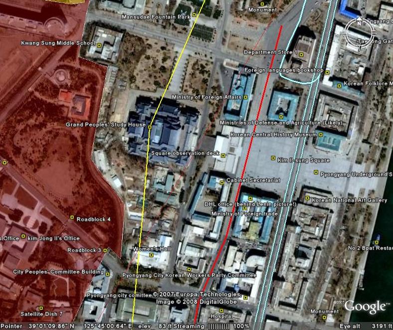
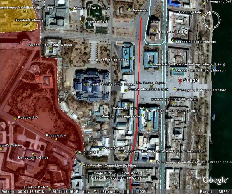
North Korea Uncovered: Version 12
Download it here
 About this Project: This map covers North Korea’s agriculture, aviation, cultural locations, markets, manufacturing facilities, energy infrastructure, political facilities, sports venues, military establishments, religious facilities, leisure destinations, national parks, shipping, mining, and railway infrastructure. It is continually expanding and undergoing revisions. This is the 12th version.
Additions include: Tongch’ang-dong launch facility overlay (thanks to Mr. Bermudez), Yongbyon overlay with destroyed cooling tower (thanks to Jung Min Noh), “The Barn” (where the Pueblo crew were kept), Kim Chaek Taehung Fishing Enterprise, Hamhung University of education, Haeju Zoo, Pyongyang: Kim il Sung Institute of Politics, Polish Embassy, Munsu Diplomatic Store, Munsu Gas Station, Munsu Friendship Restaurant, Mongolian Embassy, Nigerian Embassy, UN World Food Program Building, CONCERN House, Czech Republic Embassy, Rungnang Cinema, Pyongyang University of Science and Technology, Pyongyang Number 3 Hospital, Electric Machines Facotry, Bonghuajinlyoso, Second National Academy of Sciences, Central Committee Building, Party Administration Building, Central Statistics Bureau, Willow Capital Food House, Thongounjong Pleasure Ground, Onpho spa, Phipa Resort Hotel, Sunoni Chemical Complex (east coast refinery), Ponghwa Chemical complex (west coast refinery), Songbon Port Revolutionary Monument, Hoeryong People’s Library, Pyongyang Monument to the anti Japanese martyrs, tideland reclamation project on Taegye Island. Additionally the electricity grid was expanded and the thermal power plants have been better organized. Additional thanks to Ryan for his pointers.
I hope this map will increase interest in North Korea. There is still plenty more to learn, and I look forward to receiving your contributions to this project.
Version 12 available: Download it here
Posted in Agriculture, Animation, Architecture, Art, Automobiles, Aviation, Banking, Cell phones, Coal, Communications, Computing/IT, Construction, Copper, Dams/hydro, Education, Electricity, Energy, Environmental protection, Film, Finance, Fiscal & monetary policy, Food, Football (soccer), Foreign direct investment, Forestry, Gambling, Gasoline, General markets (FMR: Farmers Market), Gold, Golf, Google Earth, Health care, Hoteling, Hwanggumphyong and Wihwado Economic Zones (Sinuiju), International trade, Joint Ventures, Kaesong Industrial Complex (KIC), Leisure, Library, Light Industry, Lumber, Manufacturing, Mass games, Military, Mining/Minerals, Mt. Kumgang Tourist Special Zone, Music, Nuclear, Pyongyang Metro, Railways, Rason Economic and Trade Zone (Rajin-Sonbong), Real estate, Religion, Restaurants, Sea shipping, Special Economic Zones (Established before 2013), Sports, Television, Tourism, Transportation, Wind | 1 Comment »
Thursday, August 14th, 2008
The most authoritative map of North Korea on Google Earth
Download it here
 This map covers North Korea’s agriculture, aviation, cultural locations, markets, manufacturing facilities, railroad, energy infrastructure, politics, sports venues, military establishments, religious facilities, leisure destinations, and national parks. It is continually expanding and undergoing revisions. This is the eleventh version.
Additions include: Mt. Paegun’s Ryonghung Temple and resort homes, Pyongyang’s Chongryu Restaurant, Swiss Development Agency (former UNDP office), Iranian Embassy, White Tiger Art Studio, KITC Store, Kumgangsan Store, Pyongyang Fried Chicken Restaurant, Kilju’s Pulp Factory (Paper), Kim Chaek Steel Mill, Chongjin Munitions Factory, Poogin Coal Mine, Ryongwun-ri cooperative farm, Thonggun Pavilion (Uiju), Chinju Temple (Yongbyon), Kim il Sung Revolutionary Museum (Pyongsong), Hamhung Zoo, Rajin electrified perimeter fence, Pyongsong market (North Korea’s largest), Sakju Recreation Center, Hoeryong Maternity Hospital, Sariwon Suwon reservoir (alleged site of US massacre), Sinpyong Resting Place, 700 Ridges Pavilion, Academy of Science, Hamhung Museum of the Revolutionary Activities of Comrade Kim Il Sung, South Hamgyong House of Culture, Hamhung Royal Villa, Pork Chop Hill, and Pyongyang’s Olympic torch route. Additional thanks go to Martyn Williams for expanding the electricity grid, particularly in Samjiyon, and various others who have contributed time improving this project since its launch.
Disclaimer: I cannot vouch for the authenticity of many locations since I have not seen or been to them, but great efforts have been made to check for authenticity. These efforts include pouring over books, maps, conducting interviews, and keeping up with other peoples’ discoveries. In many cases, I have posted sources, though not for all. This is a thorough compilation of lots of material, but I will leave it up to the reader to make up their own minds as to what they see. I cannot catch everything and I welcome contributions. Additionally, this file is getting large and may take some time to load.
Posted in Advertising, Agriculture, Architecture, Art, Automobiles, Aviation, Banking, Biotech, Cell phones, Central Broadcasting Station, Coal, Committee for Cultural Relations with Foreign Countries, Communications, Computing/IT, Construction, Dams/hydro, Demographics, Domestic publication, Education, Electricity, Energy, Environmental protection, Film, Finance, Food, Football (soccer), Foreign direct investment, Forestry, Gambling, Gasoline, General markets (FMR: Farmers Market), Golf, Google Earth, Health care, Hoteling, Hwanggumphyong and Wihwado Economic Zones (Sinuiju), Intranet, Joint Ventures, Kaesong Industrial Complex (KIC), Kim Il Sung University, Korean Buddhist Association, Labor conditions/wages, Leisure, Library, Light Industry, Lumber, Mansu Art Studio, Manufacturing, Mass games, Maternity Hospital, Military, Mining/Minerals, Ministry of foreign Affairs, Ministry of Foreign Trade, Ministry of People’s Armed Forces, Ministry of Post and Telecommunications, Ministry of Public Health, Mt. Kumgang Tourist Special Zone, Musan Mine, Nuclear, Oil, Phoenix Commerical Ventures, Pyongyang Embroidery Institute, Pyongyang Film Studio, Pyongyang International Information Center of New Techn, Pyongyang International Trade Fair, Pyongyang Metro, Pyongyang University of Medicine, Radio, Railways, Rason Economic and Trade Zone (Rajin-Sonbong), Real estate, Religion, Restaurants, Sea shipping, Sports, Steel, Supreme Peoples Assembly, Tourism, Transportation, Wind | 6 Comments »
Saturday, May 10th, 2008
From the Nautilus Institute (presentations at bottom):
Background
Energy insecurity is a critical dimension of the North Korean (DPRK) nuclear challenge, both in its making, and in its reversal. One of the Six-Party Talks working groups, the Economy and Energy Working Group, is largely devoted to this topic, and energy assistance will play an important role in the process of denuclearization of the DPRK. Nautilus Institute maintains a unique database and set of quantitative and qualitative analytic tools to evaluate and track the DPRK’s energy economy, and has maintained working relations with North Korean scientists and technical personnel from the energy sector for more than a decade. With this capacity, Nautilus has provided a stream of policy analyses and briefings at their request to US, ROK and other officials on the DPRK’s energy needs, its likely negotiating postures and demands, and possible negotiable options. The need for such expertise in support of the Six-Party Talks is increasing.
This project ensures that the underlying data and technical analysis available at Nautilus is as up-to-date as possible, and that analysis and policy advice are available when needed by US and other officials.
The Second DPRK Energy Experts’ Working Group (2008) served to provide information and views from key experts in the field to inform the Nautilus DPRK energy sector analysis update. Experts in attendance at the meeting provided both pertinent, recent data and special insights that are being used to help to make the database as reflective as possible of actual conditions in the DPRK. This in turn provides crucial input to the analysis needed to help to inform the parties to the 6-Party talks regarding possible approaches to DPRK energy sector redevelopment.
In addition, the DPRK Energy Experts Study Group Meeting served, as did the first Meeting, as an opportunity for experts on the DPRK to exchange views on the appropriate “next steps” in DPRK energy sector redevelopment. Key outcomes of this discussion are being reflected in the updated DPRK Energy Sector Analysis. In the process of discussions, the experts in attendance helped to further develop and elaborate-as well as providing input on the prospects for-the activities and means by which the various parties concerned with Korean peninsula affairs might engage and work with the DPRK to help resolve both the DPRK’s energy problems, and, in so doing, begin to address and ameliorate the regional and global insecurities of which the DPRK’s energy problems are a key part. In particular, through the focus of the second day of the meeting on Building Energy Efficiency, progress was made on consideration of possible benefits from and approaches to improving the effectiveness of energy use in the crucial DPRK buildings sector.
The Second DPRK Energy Experts Study Group Meeting convened by Nautilus and its partners will was attended by experts in a variety of areas related to energy supply and demand in the DPRK-including electricity, coal and other minerals, the DPRK economy as a whole, trade into and from the DPRK, and the DPRK’s rural household and agricultural sectors, and energy use in buildings in general in the DPRK and elsewhere (the primary topic of the second day of the Meeting)-to review and discuss the results of existing and newly-commissioned research, and to provide insights from their own experience and their own research. A total of approximately 15 experts on the DPRK and on matters related to DPRK issues attended the Meeting, not including an additional 15 experts, representatives from the organizations partnering to fund and organize the meeting (Nautilus, Tsinghua University, USDOE), including observers from bilateral aid agencies associated with a number of countries, from international organizations, from the business sector, and others, who also lent their expertise to the workshop. On the second day of the workshop, supported by funding from a private foundation, a five-member delegation from the DPRK also attended the meeting, providing presentations and insights of their own on energy use in DPRK buildings, and on related energy sector problems and plans in the DPRK.
Presentations:
Presentation: North Korea’s Mineral Resources and Inter-Korean Cooperation
By Woo-jin Chung
Presentation: Nautilus Institute’s Analysis of the DPRK Energy Sector and DPRK Energy Paths: Update
By David von Hippel
Presentation: Analysis on DPRK Power Sector Data & Interconnection Option
By Yoon Jae-young
Presentation: DPRK Energy and Energy-Related Trade with China: Trends Since 2005
By Nate Aden
Posted in Coal, Copper, Dams/hydro, Electricity, Energy, Environmental protection, Forestry, Gasoline, Gold, Graphite, Iron Ore, Lumber, Mining/Minerals, Natural Gas, Nuclear, Oil, Wind | Comments Closed
Friday, December 14th, 2007
The most authoritative map of North Korea on Google Earth
North Korea Uncovered v.7
Download it here
This map covers North Korea’s agriculture, aviation, cultural locations, manufacturing facilities, railroad, energy infrastructure, politics, sports venues, military establishments, religious facilities, leisure destinations, and national parks. It is continually expanding and undergoing revisions. This is the sixth version.
Additions to the latest version of “North Korea Uncovered” include: A Korean War folder featuring overlays of US attacks on the Sui Ho Dam, Yalu Bridge, and Nakwon Munitians Plant (before/after), plus other locations such as the Hoeryong Revolutionary Site, Ponghwa Revolutionary Site, Taechon reactor (overlay), Pyongyang Railway Museum, Kwangmyong Salt Works, Woljong Temple, Sansong Revolutionary Site, Jongbansan Fort and park, Jangsan Cape, Yongbyon House of Culture, Chongsokjong, Lake Yonpung, Nortern Limit Line (NLL), Sinuiju Old Fort Walls, Pyongyang open air market, and confirmed Pyongyang Intranet nodes.
Disclaimer: I cannot vouch for the authenticity of many locations since I have not seen or been to them, but great efforts have been made to check for authenticity. These efforts include pouring over books, maps, conducting interviews, and keeping up with other peoples’ discoveries. In many cases, I have posted sources, though not for all. This is a thorough compilation of lots of material, but I will leave it up to the reader to make up their own minds as to what they see. I cannot catch everything and I welcome contributions.
Posted in Architecture, Art, Automobiles, Aviation, Cell phones, Civil society, Coal, Committee for Cultural Relations with Foreign Countries, Communications, Computing/IT, Construction, Dams/hydro, Department Store No. 1, Education, Electricity, Email, Energy, Film, Finance, Football (soccer), Forestry, Gambling, General markets (FMR: Farmers Market), Golf, Google Earth, Hana Electronics Company, Health care, Hoteling, Hwanggumphyong and Wihwado Economic Zones (Sinuiju), Hyesan Youth Cooper Mine, International Aid, Internet, Intranet, Juche, Kaesong Industrial Complex (KIC), Kim Chaek University of Technology, Kim Il Sung University, Korea Computer Center (KCC), Korean Buddhist Association, Korean People's Army, Light Industry, Lumber, Mansudae creative Company (art studio), Manufacturing, Mass games, Maternity Hospital, Military, Mining/Minerals, Ministry of foreign Affairs, Ministry of Foreign Trade, Mt. Kumgang Tourist Special Zone, Musan Mine, Nuclear, Pyongyang Embroidery Institute, Pyongyang Film Studio, Pyongyang Informatics Center (PIC), Pyongyang International Information Center of New Techn, Pyongyang International Trade Fair, Pyongyang Metro, Pyongyang University of Medicine, Radio, Railways, Rason Economic and Trade Zone (Rajin-Sonbong), Real estate, Religion, Restaurants, Sea shipping, Sports, Television, Transportation, Wind | Comments Closed
Sunday, November 11th, 2007
The most authoritative map of North Korea on Google Earth
North Korea Uncovered: Version 6
Download it here
 This map covers North Korea’s agriculture, aviation, cultural locations, manufacturing facilities, railroad, energy infrastructure, politics, sports venues, military establishments, religious facilities, leisure destinations, and national parks. It is continually expanding and undergoing revisions. This is the sixth version.
Additions to the newest version of North Korea Uncovered include: Alleged Syrian nuclear site (before and after bombing), Majon beach resort, electricity grid expansion, Runga Island in Pyongyang, Mt. Ryongak, Yongbyon historical fort walls, Suyang Fort walls and waterfall in Haeju, Kaechon-Lake Taesong water project, Paekma-Cholsan waterway, Yachts (3), and Hyesan Youth Copper Mine.
Disclaimer: I cannot vouch for the authenticity of many locations since I have not seen or been to them, but great efforts have been made to check for authenticity. These efforts include pouring over books, maps, conducting interviews, and keeping up with other peoples’ discoveries. In many cases, I have posted sources, though not for all. This is a thorough compilation of lots of material, but I will leave it up to the reader to make up their own minds as to what they see. I cannot catch everything and I welcome contributions.
Posted in Advertising, Agriculture, Architecture, Automobiles, Aviation, Banking, Black markets, Committee for Cultural Relations with Foreign Countries, Communications, Computing/IT, Dams/hydro, Department Store No. 1, Economic reform, Education, Electricity, Energy, Environmental protection, Film, Finance, Fiscal & monetary policy, Football (soccer), Forestry, Gambling, Gasoline, General markets (FMR: Farmers Market), Golf, Google Earth, Hana Electronics Company, Health care, Hoteling, Hwanggumphyong and Wihwado Economic Zones (Sinuiju), Hyesan Youth Cooper Mine, Kaesong Industrial Complex (KIC), Kim Il Sung University, Korea Computer Center (KCC), Library, Light Industry, Mansudae creative Company (art studio), Manufacturing, Mass games, Maternity Hospital, Military, Mining/Minerals, Ministry of Culture, Ministry of Foreign Trade, Mt. Kumgang Tourist Special Zone, Musan Mine, Music, Nuclear, Pyongyang Embroidery Institute, Pyongyang Film Studio, Pyongyang Informatics Center (PIC), Pyongyang International Information Center of New Techn, Pyongyang International Trade Fair, Pyongyang Metro, Railways, Rason Economic and Trade Zone (Rajin-Sonbong), Real estate, Religion, Restaurants, Sea shipping, Special Economic Zones (Established before 2013), Sports, Steel, Supreme Peoples Assembly, Television, Tourism, Transportation, Water, Wind | Comments Closed
Wednesday, August 29th, 2007
The most authoritative, publicly available map of North Korea
Version 4: August 29, 2007
Download it here
This map covers North Korea’s agriculture, aviation, cultural locations, manufacturing facilities, railroad, energy infrastructure, politics, sports venues, military establishments, religious facilities, leisure destinations, and national parks. It is continually expanding and undergoing revisions. This is the fourth version.
Additions to the latest version of “North Korea Uncovered” include the city of Manpo along the Chinese border, KEDO, Kumgang Resort expansion, Kaesong Industrial Zone, as well as a few more parks, antiaircraft sites, dams, mines, canals, etc. I have also added more links in the menu which will tell the viewer a bit about the locations themselves. I have also changed the color scheme to make the collage easier to view.
Disclaimer: I cannot vouch for the authenticity of many locations since I have not seen or been to them, but great efforts have been made to check for authenticity. These efforts include pouring over books, maps, conducting interviews, and keeping up with other peoples’ discoveries. In many cases, I have posted sources, though not for all. This is a thorough compilation of lots of material, but I will leave it up to the reader to make up their own minds as to what they see. I cannot catch everything and I welcome contributions.
I hope this map will increase interest in North Korea. There is still plenty more to learn, and I look forward to receiving your additions to this project.
Posted in Agriculture, Architecture, Automobiles, Aviation, Biotech, Dams/hydro, Education, Electricity, Energy, Environmental protection, Fiscal & monetary policy, Forestry, Gasoline, General markets (FMR: Farmers Market), Google Earth, Health care, Hoteling, Hwanggumphyong and Wihwado Economic Zones (Sinuiju), International trade, Kaesong Industrial Complex (KIC), Labor conditions/wages, Leisure, Library, Light Industry, Lumber, Manufacturing, Military, Mining/Minerals, Mt. Kumgang Tourist Special Zone, Political economy, Pyongyang International Trade Fair, Pyongyang Metro, Railways, Rason Economic and Trade Zone (Rajin-Sonbong), Real estate, Sea shipping, Special Economic Zones (Established before 2013), Tourism, Transportation, Water, Wind | 1 Comment »
Tuesday, August 1st, 2006
Nautilus Institute
Nathaniel Aden
August 2006
Paper here: Nautilus-Aden.pdf
web link here
Abstract: China is North Korea’s largest international trading partner. Since 1995, energy and fuels have dominated bilateral trade between allies. North Korea is a net importer of Chinese crude oil and oil products; however, it became a net exporter of electricity and coal to China in 2003. Whereas North Korean coal and electricity exports are sold at sub-market “friendship prices,” Chinese coal and oil products have been sold to North Korea at premium prices. Over the past ten years, North Korea’s imports have become increasingly energy-intensive, while exports have become more labor-intensive. Chinese customs data suggest that Beijing is taking a pragmatic, market-oriented approach to trade with its reclusive neighbor, while the increasingly asymmetrical energy embodiment of bilateral trade may reflect dilapidation of North Korea’s non-military industries.
Bullet Points:
1. In 2005, bilateral trade with the PRC accounted for 39% of North Korean international trade by value.
2. North Korean trade data are compiled by partner-country Customs Bureaus, the United Nations, and the Internaitonal Monetary fund (IMF). China and South Korea provide the best “mirror” statistics. Customs data do not include aid shipments, official development assistance, direct government transfers, foreign direct investment, services, remittances, barter trade, smuggling, illicit trade, trade in military equipment.
3. The DPRK has spent an increasing amount of money on diminishing quantities of energy imports, particularly Chinese crude. The decline of energy import volumes in the face of increasing overall imports and trade may reflect demand sensitivity to increased international market prices and/or North Korea’s lack of hard currency with which to purchase imported energy and fuels.
4. The DPRK has significant, ongoing refining capabilities.
5. Between 1985 and 2002, the DPRK domestic coal production has declined from 37.5 million tons to 21.9 million tons. Nonetheless, North Korea increased its export quantity to 2% of total domestic production since 2002.
6. Starting in May 2005, North Korea has been an uninterrupted monthly electricity exporter. Hydropower may account for much of the DPRKs surplus electric power.
7. Energy prices reflect the pragmatic, market-oriented character of China’s economic relationship with North Korea. North Korea may be providing China coal at subsidized prices, below those of China’s other trading partners.
8. North Korea coal export prices show an awareness of market prices starting in 2002.
9. The DPRK has consistently paid premium prices for Chinese oil product exports over the last ten years.
10. Aside from politically-determined prices, several conditions could explain this: 1. Real factors (transport costs, demand, goegraphy) 2. Pyongyang’s insulation from market realities 3. No DPRK leverage.
11. In 2005, North Korea imported $2omillion worht of trucks, $2 million worth of cars, $1 million of tractors. The transport sector has not grown significantly since 1995.
12. Shift of DPRK trade towards energy-intensive imports and labor-intensive exports suggests deterioration of non-military industry.
Posted in China, Coal, Dams/hydro, Electricity, Energy, International trade, Natural Gas, Nautilus Institute, Nuclear, Oil, Wind | Comments Closed
Monday, May 1st, 2006
From the Korea Herald:
The South Korean Ministry of Science and Technology yesterday announced this year’s cooperative science and technology projects between South and North Korea.
The ministry selected 15 projects, including new and ongoing ones. They are regarded as having future viability and continuity, the ministry said.
These projects will be supported for the next three years at least, while being evaluated on a regular basis, the ministry said.
For the South-North cooperative science projects, the ministry has invested a total of 4.8 billion won from 1999 to 2005. The ministry has allocated 650 million won for this year.
The 15 projects include the Korea Transport Institute’s peninsula-wide traffic specifications; Korea Center for Disease Control & Prevention’s study on malaria in North Korea; the Korea Research Institute of Chemical Technologies’ study on chemical products as basic necessities; Pohang University of Science and Technology’s training program for computing specialists; Inha University’s initiative to develop North Korea’s wind power resources; Korea Institute of Machinery and Materials’ research on North Korea-originated magnesite; Korea Research Institute of Bioscience and Biotechnology’s development of cold-resistant sweet potatoes to alleviate North Korea’s food shortage.
Also, there are Andong University’s South-North comparative study on fossils in the paleozoic era; Korea Institute of Geoscience and Mineral Resources’ peninsula-wide geological map; Science & Technology Policy Institute’s analysis on North Korea’s science and technology policy; Seoul National University’s parasite control technology; and Korea Institute of Science and Technology Information’s project for North Korean infrastructure building.
The project selection utilized the Korea Institute of Science and Technology Information’s analysis tool for documents and patents, the ministry added.
Dubbed “KITAS,” the tool has helped the ministry analyze North Korea’s 22 different kinds of academic documents, which amounted to 38,000 volumes.
The ministry then selected promising areas of cooperation, which include biotechnology, machine manufacture, and non-metal mineral exploitation.
With its food crisis, North Korea has a particular interest in biotechnology, such as plant breeding and rabbit cloning, the ministry said.
“I think biotechnology cooperation between the two Koreas will be very promising,” said Yoon Dae-sang at the ministry’s science-technology cooperation division.
Posted in Automobiles, Biotech, Computing/IT, Disease prevention, International trade, South Korea, Wind | Comments Closed
Wednesday, February 1st, 2006
A report issued by the Department of Energy: dprkenergy.pdf
Posted in Coal, Dams/hydro, Electricity, Energy, Gasoline, Natural Gas, Nuclear, Oil, Wind | Comments Closed
