North Korea Uncovered – (Google Earth)
Notice: Although some time has passed since version 18 was published, the project grows each day. In due time this information will be made public by 38 North at the US-Korea Institute at Johns Hopkins University. See also the DPRK Digital Atlas.
 |
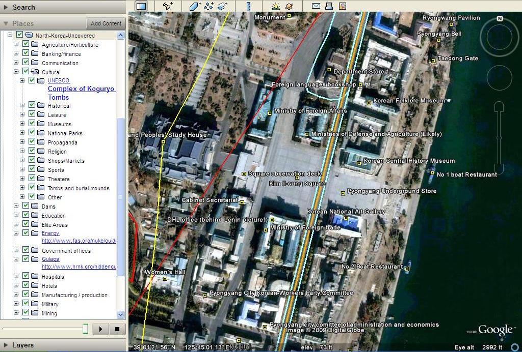 |
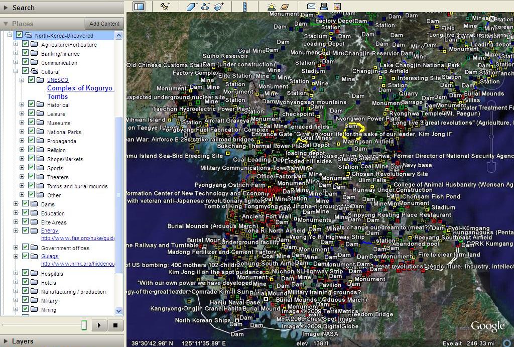
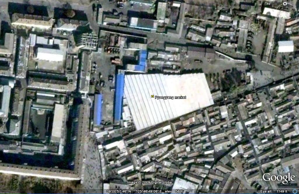
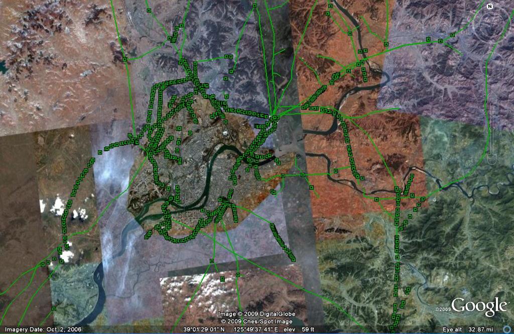
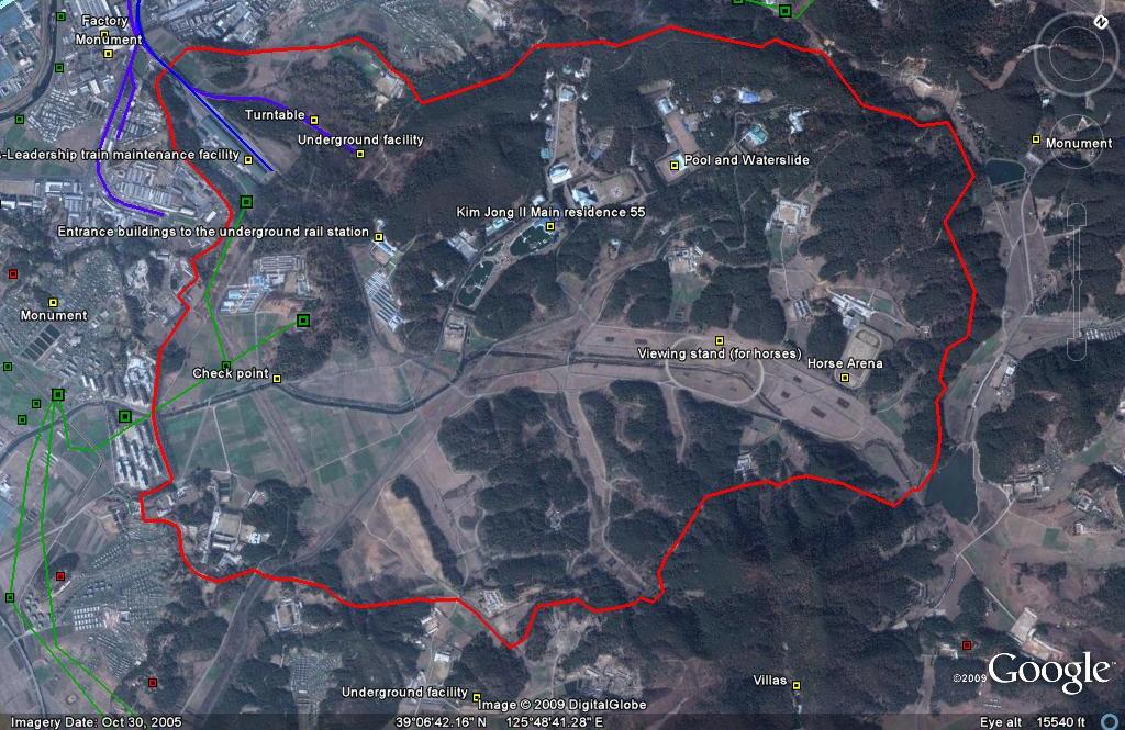
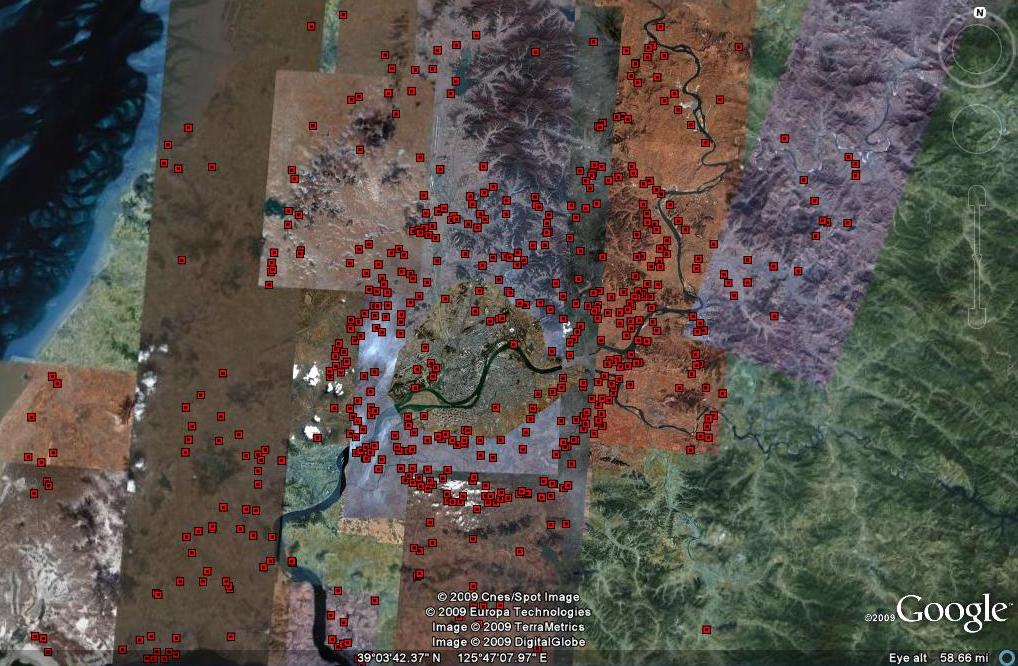
Click on the screen shots above for larger images
This Google Earth project offers an extensive mapping of North Korea’s economic, cultural, political, and military infrastructures. Through the topic menu, users of this program have easy access to geographical information on North Korea’s agriculture projects, aviation facilities, communications, hospitals, hotels, energy infrastructure, financial services, leisure destinations, manufacturing facilities, markets, mines, religious locations, restaurants, schools, and transportation infrastructure. In addition to locations of economic interest, this map also displays anti-aircraft locations, the Demilitarized Zone (DMZ) and Northern Line Limit Line (NLL), incarceration facilities, political monuments, political residencies, military bases, and nuclear facilities.
 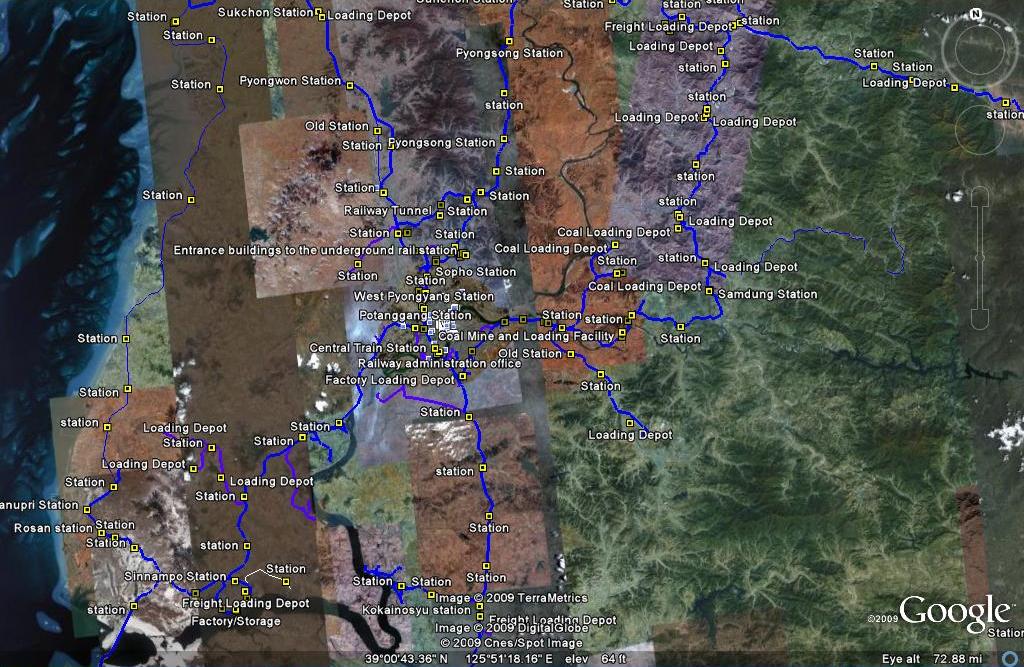 Markets Railways |
 Eletricity Grid |
 Elite Areas |
 Anti- aircraft |
In addition to the geographical information displayed on the map, many location tabs provide links to internet resources which offer more information on the specific location. Many people have contributed to this project (see project history below), and further contributions are welcome.
Since launching in April 2007, this project has been downloaded over 250,000 times and has been featured in numerous media outlets including the Wall Street Journal, CNN, Times of London, Telegraph, Independent, Der Spiegel, Choson Ilbo, NPR, Voice of America, Radio Free Asia, Washington Post, BBC, Yonhap, China People’s Daily, China CCTV, Joong Ang Daily, and the Rachel Maddow Show.
If you do not have Google Earth installed on your computer, you must download it here first.
Project History
Version 18: June 25, 2009 – Additions include: New image overlays in Nampo (infrastructure update), Haeju (infrastructure update, apricot trees), Kanggye (infrastructure update, wood processing factory), Kimchaek (infrastructure update). Also, river dredges (h/t Christopher Del Riesgo), the Handure Plain, Musudan update, Nuclear Test Site revamp (h/t Ogle Earth), The International School of Berne (Kim Jong un school), Ongjin Shallow Sea Farms, Monument to “Horizon of the Handure Plain”, Unhung Youth Power Station, Hwangnyong Fortress Wall, Kim Ung so House, Tomb of Kim Ung so, Chungnyol Shrine, Onchon Public Library, Onchon Public bathhouse, Anbyon Youth Power Stations.
Version 17: May 14, 2009 – Additions include: Hamhung City (h/t to former resident Kim Young il – PSCORE): Youth Park, Horyong Stream, Yongdae Bridge, Hamhung City Hospital, Mansu Bridge, Wonhyung Apartment Building, rumored spy training location, public execution site. Pyongyang: Italian Food Restaurant, April 25 Film Studio, Pyongyang Chewing Gum Factory. Wonsan: Museum of President Kim Il Sung’s Revolutionary Activities, Wonsan Youth Power Station No. 1. Other: Electricity grid expansion, Thaechon Youth Power Stations 1-5, Unha-2 Rocket launch image overlay, North Korean restaurants in Beijing Phom Penh, North Korean Embassies in Bangladesh, Thailand, Cambodia, Vietnam, Indonesia, Sweden, Switzerland, Cuba, Canada, France, Germany, Italy, Poland, Romania, Germany, Mexico, South Africa, Austrialia, Singapore, Russia, Austria, China, Malaysia, Britain, Iran, Uganda, Brazil, UN (New York and Geneva), North Korea’s Lighthouses (h/t Martyn Williams), Sungri Motor Plant, aviation waypoints, Kim Jong il statue (alleged), Ministry of Peoples (Public) Security, National Security Agency, Monuments in Africa by the Mansudae Overseas Development Group: Statue of Samora Machel (Mozmabique), Place d’arme (Ouagadougou, Burkina Faso).
Version 16:March 6, 2009-Additions include: Rakwon Machine Complex, Sinuiju Cosmetics Factory, Manpo Restaurant, Worker’s Party No. 3 Building (including Central Committee and Guidance Dept.), Pukchang Aluminum Factory, Pusan-ri Aluminum Factory, Pukchung Machine Complex, Mirim Block Factory, Pyongyang General Textile Factory, Chonnae Cement Factory, Pyongsu Rx Joint Venture, Tongbong Cooperative Farm, Chusang Cooperative Farm, Hoeryong Essential Foodstuff Factory, Kim Ki-song Hoeryong First Middle School , Mirim War University, electricity grid expansion, Tonghae Satellite Launching Ground (TSLG)” is also known as the “Musudan-ri Launching Station,” Laurent Kabila Monument built by the Mansudae Overseas Project Group of Companies in Kinshasa, DR Congo. Again, thanks to those who have contributed.
Version 15:February 12, 2009-Additions include: REBUILT electricity grid, Kumchang-ri suspected underground nuclear site, Wangjaesan Grand Monument, Phothae Revolutionary Site, Naedong Revolutionary Site, Kunja Revolutionary Site, Junggang Revolutionary Site, Phophyong Revolutionary Site, Samdung Revolutionary Site, Phyongsan Granite Mine, Songjin Iron and Steel Complex (Kimchaek), Swedish, German and British embassy building, Taehongdan Potato Processing Factory, Pyongyang Muyseum of Film and Theatrical Arts, Overseas Monuments built by DPRK: Rice Museum (Muzium Padi) in Malaysia, Statue de Patrice Lumumba (Kinshasa, DR Congo), National Heroes Acre (Windhoek, Namibia), Derg Monument (Addis Ababa, Ethiopia), National Heroes Acre (Harare, Zimbabwe), New State House (Windhoek, Namibia), Three Dikgosi (Chiefs) Monument (Gaborone, Botswana), 1st of May Square Statue of Agostinho Neto (Luanda, Angola), Momunment Heroinas Angolas (Luanda, Angola), Monument to the Martyrs of Kifangondo Battle (Luanda, Angola), Place de l’étoile rouge, (Porto Novo, Benin), Statue of King Béhanzin (Abomey, Benin), Monument to the African Renaissance (Dakar, Senegal). Thanks again to the anonymous readers and fans of this project for your helpful advice and location information. This project would not be successful without your contributions.
Version 14:December 20, 2008-Additions include: Myohyangsan: Sangwon Hermitage, Pohyun Temple—Mt. Kumgang: Stele for Sosan Taesa in the cemetery of Pyohunsa, Samburam, Myogilsang, P’yohunsa Temple, Manp’ok Valley, Podogam hermitage—Mt. Ryongak: Pobun Hermitage, Juche Academy, Man’gyŏngdae Children’s Union Camp—Samjiyon: Paekdu Secret Camp, School Children’s Palace, hospital, vacation camp—Mt. Chilbo: Kaesim Temple, Hadok Falls, Soryangwa Falls, Pochong Beach Resort, Chilbo Hotel—Kaesong: Songgyungwan map, Sungyang Lecture Hall, Tongil Restaurant—Chongjin: West Harbor, East Harbor, Universities of Education, University of Medicine, People’s Theatre, KPA Martyr’s Cemetary, Provincial Theatre, Chonmasan Hotel, Chonmasan Park—Railway stations: Munjong station, Pyoksong station, Jongdo station, Haeju Central station,Songpyong station, Jongkang station, Tumangang station, Sinanju station, Yomthan station, Kaephung station—Pyongyang: Kamsusan Vineyard, Taedong guest house, British Emabassy, Taedonggang Brewery, Changdok Primary School, Moranbong Hotel (new location) and Kaeson Sanitarium (Thanks for the tip!), Kum Sung Tractor Complex—Other: Hamhung University of Nursing, wind power turbines (x2), old city walls, Second Economic Committee Offices, electricity grid additions, Bronze Age Dolmen (Kangdong), Wonsan Agricultural University Main Building (former German Benedictine abbey-Togwon), Kyongsong Palace of Culture, Myongch’on food processing plant, Tongnim Mechanical Engneering Works, Nampo Salt Farm, Monument commemorating the construction of the West Sea Barrage, Rimyongsu Falls, Chonsan Cooperative Farm, Ulim Falls Teahouse, Ulim Falls, Yŏmbunjin pavilion by the East Sea, Kuwol Radside Pavilion, Suan Gold Mine, Madong Fertilizer and Cement Plant, Wonsan Sanitarium, UNESCO: Tokhwa-ri Tombs 1,2,3., Hagap Underground Facility (Overlay), Musan Mine – Ore dressing plant No. 2., Nyongwon Dam and Power Station, Sokdam Reservoir, Singwang Reservoir, Sokdam Rest Home, Sohyonso Temple, Kaephung Ginseng Farm, Yokton Hotel (Kaesong), Kum Sung Tractor Complex, Nampo University of Marine Studies, Sup’ung Hydroelectric Plant. Kernbeisser photos: Sungni (“Victory”) Bridge, Grave of Comrade Kang Sung Hyon. Handydandy81 finds: June 13 Coal Field, Aojiri Chemical Complex, 10 May Coal Machine Factory Complex, Anju Coal Field, National Defence Commission compound. State Security Department, Nyongwon Dam and Power Station, Sokdam Reservoir, Singwang Reservoir, Sokdam Rest Home, Sohyonso Temple, Kaephung Ginseng Farm, Yokton Hotel (Kaesong), Nampo University of Marine Studies, Sup’ung Hydroelectric Plant. I would like to thank the anonymous contribtors to this version of the project, “HandyDandy61” (who is doing a great job on wikimapia), and Eckart Dege who posted many of these locations on Panorimio. Without all of their help, this project would not be where it is today.
Version 13: October 15, 2008-Additions include: Adjustment of content to new image overlays (west coast, and around Pyongyang), Cholima Steel Works, Jang Chol Gu University of Commerce, Central Bank, Changwang Kindergarden, Chongryun Housing, and Maekjon Ferry Relics. Addtionally the electricity grid and railway network have been marginally imporved. Thanks to “HandyDandy61”.
Version 12:October 3, 2008-Additions include: Tongch’ang-dong launch facility overlay (thanks to Mr. Bermudez), Yongbyon overlay with destroyed cooling tower (thanks to Jung Min Noh), “The Barn” (where the Pueblo crew were kept), Kim Chaek Taehung Fishing Enterprise, Hamhung University of education, Haeju Zoo, Pyongyang: Kim il Sung Institute of Politics, Polish Embassy, Munsu Diplomatic Store, Munsu Gas Station, Munsu Friendship Restaurant, Mongolian Embassy, Nigerian Embassy, UN World Food Program Building, CONCERN House, Czech Republic Embassy, Rungnang Cinema, Pyongyang University of Science and Technology, Pyongyang Number 3 Hospital, Electric Machines Facotry, Bonghuajinlyoso, Second National Academy of Sciences, Central Committee Building, Party Administration Building, Central Statistics Bureau, Willow Capital Food House, Thongounjong Pleasure Ground, Onpho spa, Phipa Resort Hotel, Sunoni Chemical Complex (east coast refinery), Ponghwa Chemical complex (west coast refinery), Songbon Port Revolutionary Monument, Hoeryong People’s Library, Pyongyang Monument to the anti Japanese martyrs, tideland reclamation project on Taegye Island. Additionally the electricity grid was expanded and the thermal power plants have been better organized. Additional thanks to Ryan for his pointers.
Version 11:August 5, 2008-Additions include: Mt. Paegun’s Ryonghung Temple and resort homes, Pyongyang’s Chongryu Restaurant, Swiss Development Agency (former UNDP office), Iranian Embassy, White Tiger Art Studio, KITC Store, Kumgangsan Store, Pyongyang Fried Chicken Restaurant, Kilju’s Pulp Factory (Paper), Kim Chaek Steel Mill, Chongjin Munitions Factory, Poogin Coal Mine, Ryongwun-ri cooperative farm, Thonggun Pavilion (Uiju), Chinju Temple (Yongbyon), Kim il Sung Revolutionary Museum (Pyongsong), Hamhung Zoo, Raijin electrified perimeter fence, Pyongsong market (North Korea’s largest), Sakju Recreation Center, Hoeryong Maternity Hospital, Sariwon Suwon reservoir (alleged site of US massacre), Sinpyong Resting Place, 700 Ridges Pavilion, Academy of science, Hamhung Museum of the Revolutionary Activities of Comrade Kim Il Sung, South Hamgyong House of Culture, Hamhung Royal Villa, Pork Chop Hill, and Pyongyang’s Olympic torch route. Additional thanks go to Martyn Williams for expanding the electricity grid, particularly in Samjiyon, and various others who have contributed time improving this project since its launch.
Version 10:May 26, 2008-Additions include: Expansion of infrastructure (railroads, electricity grid, elite areas, political monuments, burial mounds, dams, military facilities, and factories) in Hamhung, Chongjin, Sariwon, Raijin-Songbon (Rason) and other cities. Updates in Pyongyang: Pothonggang Exhibition Hall, Ssuk Island, Patriotic Martyrs Cemetary, Ostrich Farm, Kang Pan Sok Revolutionary School, Kumsong School, Manyongdae 1,000 Seat Restaurant. Specific manufacturing facilities and companies: Wonsan Rolling Stock Factory (RR manufacturer), Songnim-Hwanghae Iron and Steel Complex, Bukchang Thermal Power Plant, Sunchon Cement Factory, Namhung Youth Chemical Complex, Feb 8 Vinalon Complex, Hamhung Wood Carving Factory, Chongjin Chemical Fiber Complex, Unjong-ri Cooperative Farm, Sariwon Chicken Farm, Kanggye Chicken and Duck Farm, Hungju Youth Power Station, Korea Rason Taehung Trading Corporation. Updated Cultural Locations: Paeksang Pavilion (Anju), Site of the DPRK’s first Cricket game (2008), Sariwon Folk Village, Sinpha Revolutionary Site, International Friendship Exhibition, Paeksang Pavilion, Lake Sijung. Other locations: air force test bombing range, Kyo hwa so 1: Kaechon (overlay). Most canals were eliminated from this version except the major projects on the west coast.
Version 9:March 13, 2008-Additions include: updated Yongbyong nuclear facilities, Songchon Barrage, Ponghwa Barrage, Sunchon Barrage, Mirim Barrage, Uiju Nam Gate, Chongju old fort wall, Pyongsan old fort wall, Kwaksan old fort wall, the original Pueblo location in Wonsan, and lots of markets in places such as Pyongyang, Wonsan, Nampo, Sinuiju, Haeju, and Sunchon.
Version 8:January 23, 2008-Additions include: Mangyongdae Chicken Farm, Pochonbo Revolutionary Site, Raknang Health Recuperation Centre, Paek Son Haeng Memorial Hall , Sosan Shooting Range, Sangwon Cement Factory (low resolution), Kwangbop Temple, Mt. Teasong Fort Walls, Ryongnam Ship Repair Dock 2 (Nampo), Pyongyang zoo building for animals gifted to KJI, NLL island video, Pyongyang Catfish farm, Kaesong Market, Pyongyang Building Materials Factory, the Unryul Mine, and corrected technical errors in version 7.)
Version 7:December 13, 2007-Additions Changes include: A Korean War folder featuring overlays of US attacks on the Sui Ho Dam, Yalu Bridge, and Nakwon Munitians Plant (before/after), plus other locations such as the Hoeryong Revolutionary Site, Ponghwa Revolutionary Site, Taechon reactor (overlay), Pyongyang Railway Museum, Kwangmyong Salt Works, Woljong Temple, Sansong Revolutionary Site, Jongbansan Fort and park, Jangsan Cape, Yongbyon House of Culture, Chongsokjong, Lake Yonpung, Nortern Limit Line (NLL), Sinuiju Old Fort Walls, Pyongyang open air market, and confirmed Pyongyang Intranet nodes.
Version 6:November 7, 2007-Changes include: Alleged Syrian nuclear site, Majon beach resort, electricity grid expansion, Runga Island in Pyongyang, Mt. Ryongak, Yongbyon historical fort walls, Suyang Fort walls and waterfall in Haeju, Kaechon-Lake Taesong water project, Paekma-Cholsan waterway, Yachts (3), and Hyesan Youth Copper Mine.
Version 5:October 6, 2007-Changes inlcude: Sinchon addition, UNESCO, DMZ, RR update, Kim Jong Suk college of education (Hyesan), Martin Williams contributed to expanding the power grid, Korea Computer Center, Kim Jong Suk Nursery, sports facilities.
Version 4:August 29, 2007-Changes include: KEDO expansion, Kumgang expansion, Kaesong expansion, RR expansion, Manpo area, burial mounds, AA, Monuments, expand canals.
Version 3:July 29, 2007-Changes include: UNESCO sites, Kim Jong Il’s Yacht, Pyongyang’s golf course, and the Chinese-Built Taen Friendship Glass Factory.
Version 2: July 5, 2007-Changes include: highway addition, railroad expansion, monuments, burial mounds, AA sites, new temple, corrections, and canals.
Version 1: April 4: 2007-Project Launch. Thanks to “Wonders (member 166393)” for starting me on this project.
Search terms:, North Korea Google Earth, Google Earth North Korea, DPRK Google Earth, Google Earth DPRK, North Korea Map, Map of North Korea.
