UPDATE 3 (2017-2-10): According to the White Paper on Human Rights in North Korea 2013 (2013-05-16), this new prison camp was formed from the remnants of the closed Camp 18 in Pukchang County:
2012년에 확인된 또 다른 변화로는 평남 북창군 신흥리 및 삼포동 일대에 위치하던 북창 18호 관리소가 대폭 축소되어 평남 개천 동림리 지역으로 이전하였다는 사실이다.
Another change confirmed in 2012 is that Camp 18, located in the vicinity of Pukchang, Pyongnam, got downsized by a large degree and moved to 동림리, 개천, Pyongnam.
18호 관리소가 관할하던 지역은 단 계적 해제 과정을 거쳐 일반시설로 환원되었고, 여전히 해제되지 않은 수용자들은 2006~2007년경 개천 지역으로 이전한 것으로 파악된다.
The area controlled by Camp 18 got gradually disassembled and changed into a general facility [Pongchang Coal Mine], and remaining inmates were sent to 개천 area in around 2006 and 2007.
현재 18호 관리소의 수용인원은 2009년 정부 추정치인 1만 9천 명보다 훨씬 축소된 2천~5천 명 규모로 추정된다.
The current estimate of the number of inmates in Camp 18 ranges from 2,000 to 5,000, much down from the 2009 government estimate of 19,000.
However, as of 2013 the former Camp 18 location has been reopened as a new prison camp. Its name and administrative classification are still unknown.
UPDATE 2 (2016-3-17): Joseph Bermudez has written about this site for HRNK, in which he calls it “Ch’oma-bong Restricted Area“.
UPDATE 1 (2013-1-21): Thanks to the Daily NK and Wall Street Journal for helping to reach out to others who may know about this facility. Here is an interview I did for NPR.
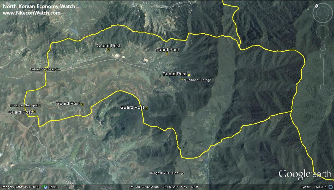
ORIGINAL POST (2013-1-18): Today (Friday) Google Earth was updated with new satellite imagery (dated 2011-9-21) of the area around Camps 14 and 18 (Kwan-li-so 14). Camp 18 is said to have been closed for a few years and the area has even been featured on North Korean television (See Pongchang District Coal Mine, 봉창지구탄광, here and here).
While updating my Google Earth file to match the new satellite imagery, however, I noticed the addition of a new area that bears striking similarity to other known “kwan-li-so (관리소)” or prison camps. This area was built sometime between 2006-12-17 and 2011-9-21. It is surrounded by a very visible security perimeter. It is also placed right next to Camp 14– even sharing 3kms of border.
![]()
![]()
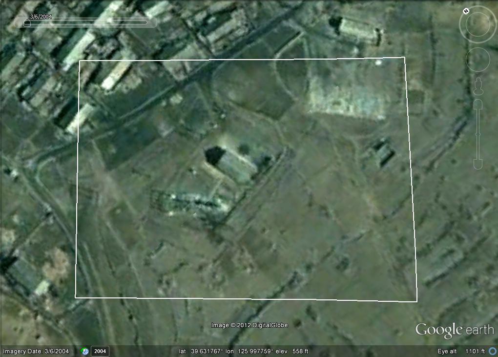
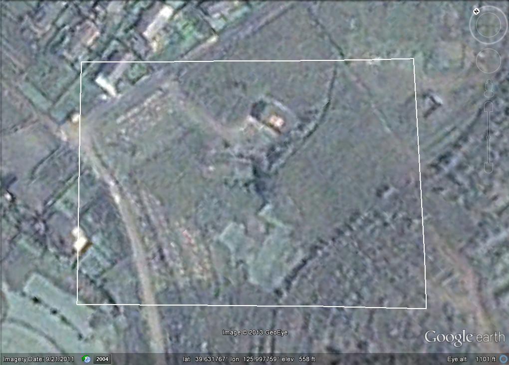
Pictured Above (Google Earth): The location of interest next to Camp 14 in Kaechon County
Let’s look at this new area more closely. The security perimeter is approximately 20km in circumference There are two entrances on the northwestern edge of the fence:
![]()
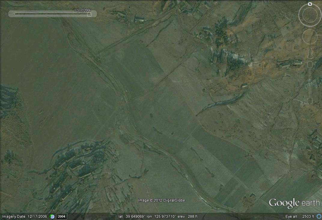
Pictured above is the northern most entrance. The picture on the left is dated 2006-12-17. The picture on the right is dated 2011-9-21.
![]()
Pictured above is the southern entrance. This appears to more of a staff or auxiliary entrance.
There appear to be six new buildings constructed around the perimeter that could serve as guard posts/facilities. Three of them are identical:
There has been some new residential and administrative units added to the interior as well:
![]()
Pictured above (Google Earth): Residential and administrative construction within the perimeter fence. This village does not appear on any North Korean atlas that I have seen.
There is an old coal mine inside the perimeter fence, but it does not appear to be operational. Comparisons of debris show that coal piles have become overgrown with trees since 2004. In addition, the electrical substation that was located here to power the mine (before the fence was built) has been removed:
So I don’t want to jump to any conclusions here, but this facility certainly raises flags. I look forward to hearing opinions and information/criticism from the wider North Korea-watching community.
