Huichon Power Station on Google Earth
The Huichon Power Stations 1 & 2 (희천1호발전소, 희천2호발전소) are too new to appear on Google Earth satellite imagery. I have, however, mapped them out by hand on the old imagery to give a better idea of their locations. I have also tagged them on Wikimapia.

In the picture above you can see that the Huichon Power Station’s headwaters begin in Ryongrim County (룡림군) where the newly-built Ryongrim Dam holds back a large reservoir. This reservoir drains through a tunnel [in orange in the image above] approximately 30 km long (18.5 miles) and empties through the Huichon Power Station No. 1 in Tongsin County into the Chongchon River. The river flows south where it crosses into Huichon County and builds up behind a second reservoir. From this second reservoir the water drains out directly through the Huichon Power Station No. 2.
The construction of the Ryongrim Dam has resulted in the destruction of at least two villages, Toyang-ri (도양리) and Sinchang-ri (신창리). Toyang-ri was destroyed for the dam itself. Sinchang-ri was flooded by the reservoir. A third village, Kuryong-ri (구룡리), was also likely flooded or relocated—although this cannot be confirmed with current satellite imagery. The destroyed villages were probably relocated to Ryongrim Town itself. On several recent occasions North Korean television has highlighted improvements in housing and leisure facilities within the town.


When Kim Jong-il gave guidance visits to this site he often stood on the eastern side of the dam which offers the view captured in the image above (R).
The Huichon Power Station No. 1 itself is located in Tongsin County aproximately 30km due south from the Ryongrim Dam (40.273568°, 126.526565°).


In the satellite image above I have drawn the physical location of the power plant. Next to and below it I have posted images from KCTV dated 2011-3-10.
The Huichon Power Station No. 2 lies on the Chongchon River just south of the border with Tongsin.


This project might have resulted in the destruction of one village, Kyonghung-ri (경흥리), in Tongsin County, but this is impossible to confirm without better satellite imagery.
So where will the electricity produced at these new power stations be consumed? On January 21, 2012, Rodong Sinmun reported the answer:
Like the warm hands of leader Kim Jong Il, the transmission lines from the Huichon Power Station are now almost stretching out for the capital city of Pyongyang.
To meet the great expectations of Kim Jong Il who entrusted them to such a gigantic work, the builders of the power station have gained great successes.
They have erected big dams, cut waterway tunnels and carried out other bulky tasks that were said to take ten years and more; and in the wake of trial operation of generating equipment at the Huichon Power Station No. 1, they successfully assembled the hulks of generators at the Huichon Power Station No. 2.
These successes had an immediate chain reaction on the scaffold workers laying transmission cables from the power station to the capital city.
They have already laid transmission cables in scores of kilometer long section, while preceding the construction of pylons in two months.
By their heroic labor, the excavation work to lay the foundation for the pylons have been wound up, too.
Now, their job is concrete tamping of the pylons’ foundations. By introducing new work methods they are hastening their work of erecting pylons as firm as would stand for many hundred years.
Now that power lines have been lain in major sections, they have buckled down to laying the power lines in the remaining sections and erecting transformer substations to reach the capital city as early as possible.
It won’t be long before we can see the power lines reach Pyongyang amid the cheers of the citizens.
Since I have mapped out a significant portion of the North Korean electricity grid on Google Earth, I can point out an area where I believe these power cables are being constructed. In the image below, dated 2010-9-14, I have connected the power cable tower construction sites with a yellow line:

In the image above there are approximately 146 power cable towers under construction between Pakchon (North Pyongan-top of image) and Sunan (Pyongyang-bottom of image). Of course, to be certain that these are the specific lines connecting Huichon and Pyongyang, I will need more imagery.
More on the Huichon Power Stations here.
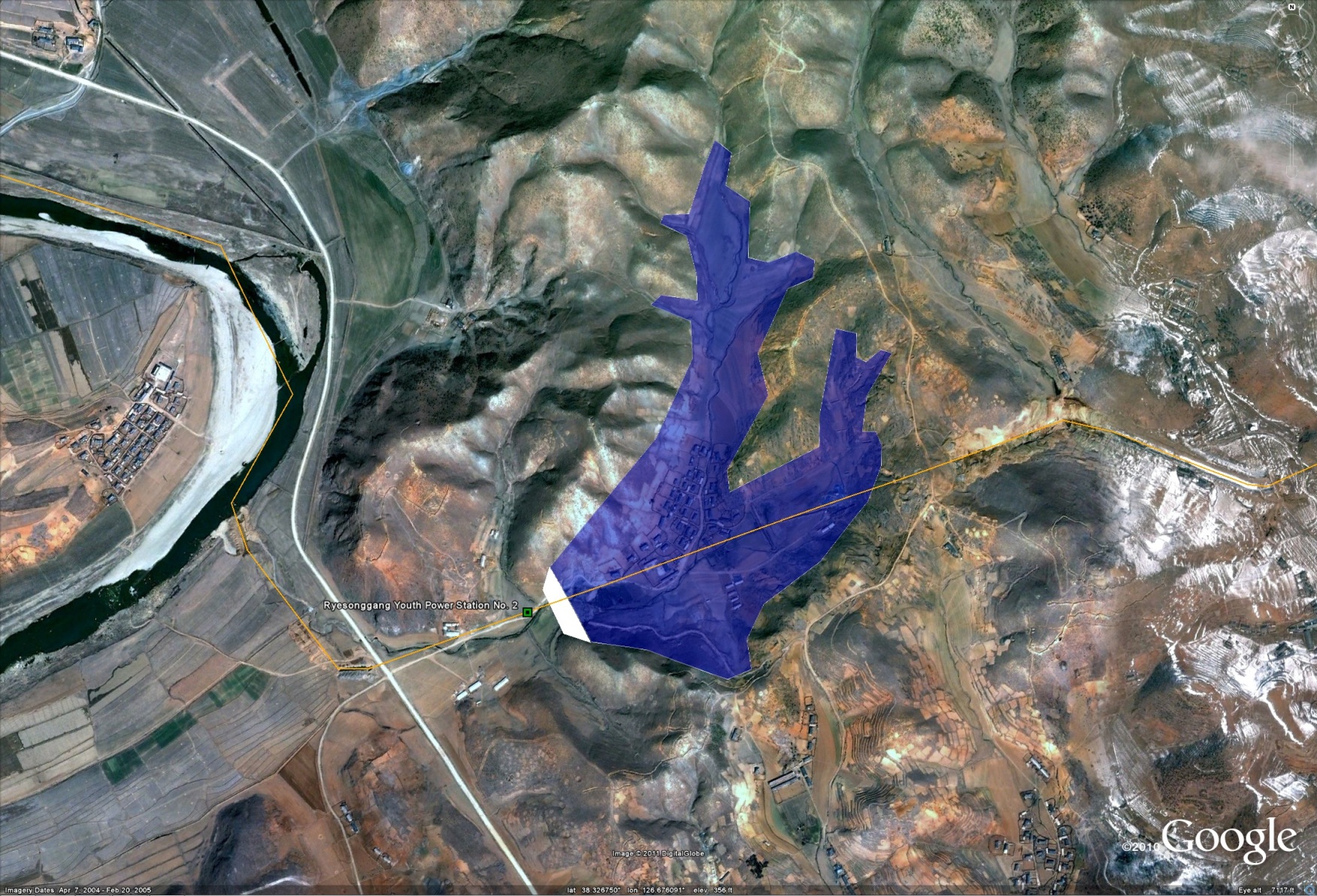
Ryesonggang Power Station 2 update
I previously wrote about the Ryesonggang Power Station No. 2 here. Since a newer satellite image has come to my attention that shows the project completed, however, I thought I would post an update.


Ryesonggang Power Station No. 3
On June 25, 2011 North Korean television showed construction of the Ryesonggang Power Station No. 3 had begun. The DPRK submitted this project to the UNFCC’s Carbon trading program. Using satellite imagery, we can see that construction is indeed well under way:


The satellite images above are dated 2007-10-4 (L) and 2011-3-23 (R). In the right-hand photo I have boxed in the construction site and the quarters and facilities of the construction workers.
UPDATE: This was picked up by Radio Free Asia.
